

GEORGE F. LEE / GLEE@STARADVERTISER.COM
Active lava fissures near what is now the end of Leilani Street continued to spew forth lava in Leilani Estates near Pahoa on Thursday night. Silhouetted are residents and members of the media.

COURTESY PAMELA MIZUNO
An ash eruption at the Kilauea summit resulted in a plume that reached 10,000 feet high today.

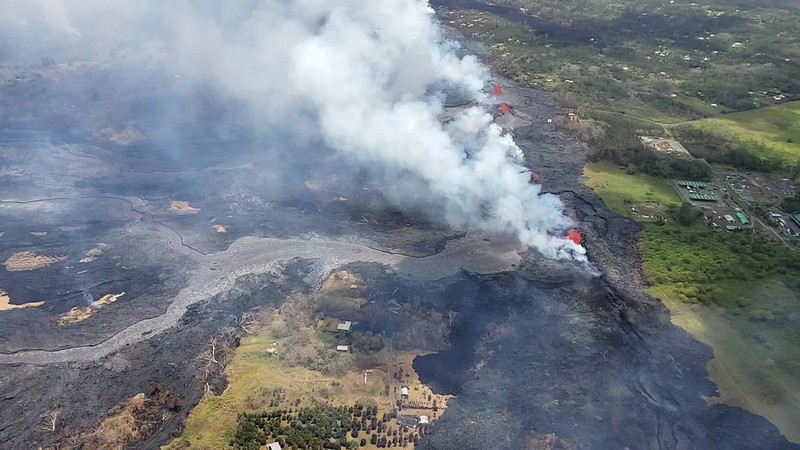
COURTESY HAWAII COUNTY FIRE DEPARTMENT
Eruption activity continues in the Lower East Rift. Volcanic gas emissions are elevated from the fissure eruptions.

GEORGE F. LEE / GLEE@STARADVERTISER.COM
Area residents watched and recorded video as Kilauea volcano continued her fiery show, throwing lava several stories into the air and building cinder cones in Leilani Estates Wednesday evening.

GEORGE F. LEE / GLEE@STARADVERTISER.COM
Kilauea volcano shot lava several stories into the air and building cinder cones in Leilani Estates at what is now the end of Kahukai Street, on Wednesday evening.

COURTESY USGS
Blue burning flames from methane gas are observed in the cracks on Kahukai Street in the Leilani Estates subdivision early Wednesday.

COURTESY HAWAII NATIONAL GUARD
The left aerial photo of Leilani Estates and Lanipuna Gardens was taken by the Hawaii Air National Guard’s Eagle Vision team in May 2017, while the photo on the right was taken Wednesday at at 11:21 a.m.

COURTESY USGS
The lava fountain from fissure 22 was not as high as several days ago, but was still erupting significant lava this morning, according to scientists from the Hawaiian Volcano Observatory.
UPDATE: 9 a.m.
A lava flow originating near the center of the Leilani Estates subdivision is moving to the northeast in a development that could threaten Highway 132, an important access road for authorities and an evacuation route for remaining residents.
The flow from fissure 21 has been moving north along Kaupili Street to about 200 yards south of Kahukai Street at the edge of the Leilani subdivision, “but the flows are sluggish in the northeast direction,” said county spokeswoman Janet Snyder.
Another lava breakout from the same fissure system has occurred nearer to Mohala Street, she said, and fissure 3 in the same area has also been active.
>> Blue flames from methane vents surprise scientists
>> Third lava flow reaches ocean as Kilauea keeps pumping
>> Puna family still in shock; others hold on, hoping they’ll be spared
>> Lava creeping toward Highway 132 in Lower Puna
>> Evacuation by air could have Lower Puna residents out in hours, official says
>> Volcano could dent booming tourism industry
>> Puna man ‘just wanted to live’ after nearly losing leg to lava bomb
RELATED PHOTOS AND VIDEO
>> Live webcams from Hawaii island
>> Photos: Lava in Leilani Estates, May 23
>> Photos: Lava approaches Puna Geothermal Venture, May 22
>> Photos: Pahoa community meeting, May 22
>> Video: Victor Hoapili talks as lava fountains erupt in his backyard
>> Video: Ken Szymanski talks about lava fissures in his neighborhood
COMPLETE KILAUEA COVERAGE
>> Star-Advertiser volcano coverage
>> Kilauea Volcano YouTube playlist
“If fissures start opening up north, we may have to look at inundation of (Highway) 132,” she said. That highway extends from Pahoa village to Kapoho, and has become an increasingly important transportation route since lava severed Highway 137 on the Puna coast south of Pohoiki.
If Highway 132 is cut near its intersection with Pohoiki Road, Highway 137 along the coast from Kapoho to Hawaiian Beaches would become the last remaining route in and out of the Pohoiki and Kapoho areas.
Snyder said scientists are waiting for data from an observation overflight, and expect to have more details about the potential threat to Highway 132 later today.
Lava from fissure 22 continues to feed one lava river that is flowing into the ocean, while fissures 6 and 13 are feeding a second ocean entry, she said.
Lava flowing in the Lower East Rift Zone has so far destroyed at least 47 structures, and Snyder said it has covered an estimated 15,000 acres.
At the Kilauea summit about 25 miles away, there were a series of strong explosions starting last night at 6 p.m. and continuing today, but very few earthquakes, she said. Those ash eruptions have not released any lava, but have scattered a layer of ash across Pahala and other communities in Kau.
7 a.m.
Lava flows continue on Kilauea volcano’s east rift and Leilani Estates while lava is still entering the ocean near MacKenzie State Park, according to Hawaii County Civil Defense.
5 a.m.
Fissure 22 continues to erupt lava, which is flowing southeast into the ocean.
Fissures 7 and 21 are feeding a perched lava pond and flow of pāhoehoe lava — basaltic lava with a smooth or ropy surface — that has advanced eastward covering most of the area bounded by Leilani Blvd, Mohala St., and the fissure line, according to the Hawaiian Volcano Observatory.
Fissure 17 continues to spatter weakly, while Fissures 19 and 23 are no longer active.
Volcanic gas emissions remain very high from the fissure eruptions.
THURSDAY, MAY 24
6:30 p.m.
An ash eruption at the Kilauea summit occurred at about 6 p.m. today, the Hawaiian Volcano Observatory reports.
The resulting ash plume reached 10,000 feet high and may affect the surrounding areas. The wind may carry ash to the southwest toward the Pahala area.
Due to the volcanic activity, the following is recommended:
>> If you are at home, stay indoors with the windows closed. If you are outside, seek cover.
>> If you are in your car, keep the windows closed. Ash fallout may cause poor driving conditions, due to limited visibility and slippery driving conditions. Drive with extreme caution, or pull over and park.
>> After the hazard has passed, do check your home, and especially your catchment system for any impact that may affect your water quality.
Kilauea Lower East Rift Zone Fissures and Flows, May 24 by Honolulu Star-Advertiser on Scribd
PREVIOUS COVERAGE
A third lava flow is entering the ocean in lower Puna, the latest hitting the water between Pohoiki Bay and MacKenzie State Park, Hawaii County Civil Defense officials said today.
They continue to warn the public to be aware of the laze (or lava haze), the mixture of gas and glass particles that is created from the plumes created when lava hits the water.
Hawaiian Volcano Observatory officials said the lava eruption continues today in Leilani Estates and Lanipuna Gardens from fissure 22, which is feeding the two other ocean entries.
Also, fissure 7 reactivated this morning and is fountaining lava. The flow from fissure 7 is moving east into Leilani Estates, and has already covered Kaupili and Mohala streets, between Leilani Avenue and the fissure line.
Civil Defense officials also warn residents down rift of the lava flows to be prepared to evacuate at a moment’s notice.
Two CH-53E Super Stallion helicopters were deployed to Hilo today by the U.S. Marine Corps in support of Joint Task Force 5-0, the military effort to assist Hawaii County with the current Kilauea eruption and possible evacuations.
Each CH-53E can carry more than 50 passengers at a time. Now that Highway 137 on the coast is closed by lava flows, authorities are concerned that air evacuations may be needed if Highway 130 becomes impassable also.
“The additional helicopter support from USPACOM and MARFORPAC provides the County of Hawaii and Hawaii’s Joint Task Force-50 tremendous capability,” said JTF 5-0 commander, Brig. Gen. Kenneth Hara. “We now have the capacity to evacuate all of the estimated population of lower Puna south of the lava flow within a few hours.”
The announcement comes on another active day for the lava outbreak that has inundated the Lower Puna communities of Leilani Estates and Lanipuna Gardens.
Hawaiian Volcano Observatory scientists say the eruption of lava in the subdivisions is most active in the middle portion of the fissure system, near Pohoiki Road, which is producing “the most robust eruptive activity in the Lower East Rift Zone.”
They said several fissures between Luana and Kaupili streets, also reactivated and are spattering.
The lava fountains from fissure 22 feed a single lava channel that enters the water just north of MacKenzie State Park. Fountains are also erupting from fissures 5, 6, 13 and 19 and continue to feed a lava flow advancing to the south along the west side of fissure 22 flows that reached the ocean late Wednesday afternoon, officials said.
Volcanic gas emissions remain high from the fissure eruptions. County, state and federal crews continue to monitor the area around the shuttered Puna Geothermal Venture plant for sulfur dioxide and hydrogen sulfide gas, but have not detected any of the latter.
In addition, trace ashfall over the Kau district from Kilauea volcano is still possible today.
At Kilauea volcano’s summit, small ash emissions from the Overlook crater continued overnight, with ash emissions reaching 6,000-feet elevation “during the most energetic explosions … but dispersed quickly,” an HVO morning update said. “Moderate trade winds were blowing to the southwest and light ashfall likely occurred in downwind locations.”
“Web cams, observers and radar data indicate that occasional small bursts of volcanic ash continue to emanate from Halemaumau Crater,” said weather officials in a National Weather Service bulletin. The communities of Pahala, Wood Valley and Naalehu are most likely to be affected.”
Facebook not showing Honolulu Star-Advertiser headlines in your news feed? Here’s how to fix it.


By participating in online discussions you acknowledge that you have agreed to the Terms of Service. An insightful discussion of ideas and viewpoints is encouraged, but comments must be civil and in good taste, with no personal attacks. If your comments are inappropriate, you may be banned from posting. Report comments if you believe they do not follow our guidelines.
Having trouble with comments? Learn more here.