Lava threatens a key escape route, forces evacuations


DENNIS ODA / DODA@STARADVERTISER.COM
Lava fountained from fissure 8, as seen Wednesday night from Kupono Street in Leilani Estates.

DENNIS ODA / DODA@STARADVERTISER.COM
Police escorted two large bulldozers on Highway 130 toward Chain of Craters Road. The bulldozers will be used to create an escape route for residents still living in lower Puna. Chain of Craters Road has been covered by lava for years by a lava flow, and the bulldozer will crush the lava rocks and grade a new, drivable path.

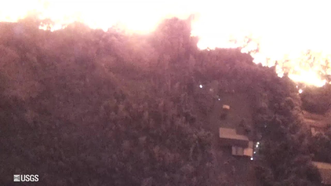
U.S. GEOLOGICAL SURVEY
Above, lava erupted from fissure 8 on Wednesday morning. The lava channel was estimated to be about 100 feet wide.

DENNIS ODA / DODA@STARADVERTISER.COM
An outbreak of Pahoehoe lava, photographed from a search aircraft, that was very rapidly moving north down Luana Street into a portion of Leilani Estates. Searchers attempted to evacuate a resident who was about to be stranded by the fast-moving flow. By monitoring the flow from the air, they were able to advise those on the ground of its progress.

DENNIS ODA / DODA@STARADVERTISER.COM
Above, Sgt. Andrew Jackson masked up as sulfur dioxide levels were at 2 parts per million near the eruption from fissure 8 on Luana Street in Leilani Estates.

HILO >> Police launched a dramatic house-to-house evacuation of the Vacationland and Kapoho Beach Lots subdivisions in Puna early Wednesday morning as fast-moving lava threatened the last route out for residents of those communities, but the flow slowed later in the day without blocking the coastal highway.
Hawaii County Civil Defense officials began allowing residents back into the subdivisions at about 9 a.m. Wednesday to retrieve their belongings and check on their homes, but again urged everyone to leave the area by 6 p.m. to avoid being trapped if the lava continued to advance.
>> Scientists debate whether Leilani eruption is ‘new’
>> Pahoa man, 61, charged with armed robbery after shots fired in Leilani Estates video
>> Lava scientists’ drone guides lost resident through jungle
>> Lawmaker wants emergency orders to help house lava evacuees
>> More Puna residents advised to evacuate as lava advances
>> State cites lava gawkers who bypass security checkpoints
>> Puna man ‘just wanted to live’ after nearly losing leg to lava bomb
RELATED PHOTOS AND VIDEOS
>> Live webcams from Hawaii island
>> Hawaii Army National Guard Major Jeff Hickman provides an update, May 31
>> Leilani Estates residents talk about evacuating as lava advances, May 31
>> Hawaii Fire Department tracks lava from the air, May 30
>> Aerial view of lava flow in Leilani Estates, May 29
>> No break over holiday weekend for Kilauea, May 28
COMPLETE KILAUEA COVERAGE
>> Star-Advertiser volcano coverage
>> Kilauea Volcano YouTube playlist
In another development Wednesday, crews began clearing cooled lava from a half-mile section of Chain of Craters Road to open an emergency route that could be used to help residents evacuate from Kalapana, Kalapana Seaview Estates, Kehena and other subdivisions in the Lower Puna area.
That work should be completed in a week or two, according to a spokeswoman for the Hawaii Volcanoes National Park, and would provide an escape route through the park if Highway 130 is severed near Pahoa. Magma has been passing under Highway 130 and has opened cracks in the pavement, but the road remains open to local traffic.
The lava flow that headed toward Kapoho early Wednesday moved quickly in part because it was the hottest lava to surface yet in the current eruption from Kilauea Volcano, emerging from a fissure in Leilani Estates subdivision and racing northeast down a slope toward the sea. The front edge of the flow at times moved at speeds of 600 yards (0.34 miles) per hour early Wednesday morning.
That rate of advancement for lava is “very fast for this type of flow,” said Wendy Stovall, a U.S. Geological Survey volcanologist. “This one is different because it’s not flowing south and downslope, and it kind of followed the highway instead of taking the path of steepest descent from our projected models….Those were all surprises.”
Gary Banks, 66, said he packed belongings in his Subaru and bugged out of his home, which stands on 16-foot piers on the shoreline in Vacationland. With him was his wife, Sachie Ohia, and two friends who were staying with them after being forced to evacuate from Leilani Estates.
“We were sound asleep, and the police cars came through in a line, one behind the other with their sirens going, announcing they were evacuating on their loudspeaker systems,” he said. “We’d been planning for weeks, and knew approximately what to take.”
Hawaii Civil Defense Agency Administrator Talmadge Magno estimated that Kapoho has 350 homes and Vacationland has 150, but Banks said about two thirds of those Vacationland properties are vacant short-term rentals.
About half of the permanent Vacationland residents had already evacuated, which left only about 20 families in the subdivision when police arrived, Banks said. “Even the die-hards, I found out today, had left,” he said.
The one-lane rural route designated as Highway 137 was converted into a one-way route out of the Lower Puna area to ease the flow of evacuation traffic. County Department of Public Works crews helped residents to move their belongings in an operation that was completed at about 2:30 a.m., said county spokeswoman Janet Snyder.
Snyder was unable to say how many people were evacuated overnight. A total of 353 people were gathered at three Puna emergency shelters Wednesday afternoon, but many of those residents were evacuated from Leilani Estates and other parts of Puna earlier in the month.
Staff was added to the two county-run shelters at Pahoa Community Center and Keaau Community Center, according to a county spokeswoman.
By Wednesday afternoon the flow was still about 2.6 miles from the intersection of Highways 132 and 137, an intersection known locally as the Four Corners. If the flow crosses Highway 137 as it appeared to be poised to do, it would cut off access to the subdivisions in the area.
Although the leading edge of that lava flow slowed to less than 85 yards (0.05 miles) per hour, Stovall said field reports indicated fissure 8 that was feeding lava into the flow “is doing exactly what it’s been doing for essentially the past 12 hours — fountaining heights are high, above 200 feet, and there just no sign of waxing or waning in that fountain itself.”
Banks built his Vacationland house himself and rode out Tropical Storm Iselle there in 2014, but he doesn’t know what will happen now. “I’m hoping and praying, and my wife’s very big on this too, that the lava will take a turn and leave Vacationland alone,” he said.
Lava flowing from other fissures in the Leilani area toward the southeast continued to flow toward the ocean Wednesday, with lava from fissure 18 feeding a flow that reached to within about a half-mile of the famous coastal warm pond at Ahalanui, scientists said.
At the Kilauea summit about 25 miles away, a 4.5-magnitude earthquake shook the Volcano village at 10:57 a.m., and an ash eruption at about 11 a.m. tossed ash up to about 12,000 feet, said Jim Kauahikaua, geophysicist with the U.S. Geological Survey.
Magno said county officials are in discussions with the Federal Emergency Management Agency about housing for residents who have been displaced by the lava, “whether its long range, or maybe even some new housing developments for these folks, affordable housing developments.”
The Lower East Rift eruption that began May 3 has destroyed 75 homes.
Kilauea Lower East Rift Zone Fissures and Flows, May 30 by Honolulu Star-Advertiser on Scribd


