Kilauea lava inundates Kapoho Bay


U.S. GEOLOGICAL SURVEY
Lava originating from fissure 8 flowed into Kapoho Bay on Monday morning. U.S. Geological Survey geophysicist Jim Kauahikaua said Monday afternoon that the bay was about halfway filled and that lava continues flowing vigorously.

CINDY ELLEN RUSSELL / CRUSSELL@STARADVERTISER.COM
Lava spilled into the waters of Kapoho Bay, creating a large plume of “laze” Monday afternoon as seen from a Lava Ocean Tours boat offshore. Officials reported the bay was about half filled with lava Monday.

At Kilauea’s summit, Hawai‘i Volcanoes National Park sustained major damage from a 5.5-magnitude earthquake that struck Sunday.
HILO >> Kapoho Bay near Hawaii island’s eastern tip was being filled up by lava Monday, adding a special coastal area to the tally of destroyed natural or built properties since volcanic eruptions near Pahoa began May 3.
U.S. Geological Survey geophysicist Jim Kauahikaua with the Hawaiian Volcano Observatory said Monday afternoon that the bay, which lava reached Sunday night, was about halfway filled and that lava continues flowing vigorously.
Kauahikaua said the eruption is producing molten rock at a roughly estimated rate of a few hundred cubic meters per second primarily from one vent, No. 8 in the Leilani Estates subdivision about 3 miles from the bay. The fissure is spewing lava like a geyser 150 to 250 feet into the air and feeding a channel leading to the bay and a few smaller channels in other directions.
>> Lava destroys Big Isle mayor’s home
>> Magnitude-5.5 quake shakes summit of Kilauea
>> Website to centralize Big Island air quality reporting
>> Kilauea eruption harms up to half of Malama Ki forest reserve
>> Volcanoes National Park’s most important facility damaged by quake
>> Fire helicopter rescues woman, her pet rabbit and chicken isolated by lava
>> 18 arrested in past week for loitering in lava zone
>> Man charged with running Puna checkpoint near approaching lava
>> #PunaStrong puts on its own show amid lava disaster
>> Lava flows reignite debate over the safety and future of the Puna Geothermal Venture facility
>> Big Isle mayor envisions ‘whole new community’ for Puna
RELATED PHOTOS AND VIDEOS
>> Live webcams from Hawaii island
>> Weekend lava activity on Hawaii island in photos, June 4
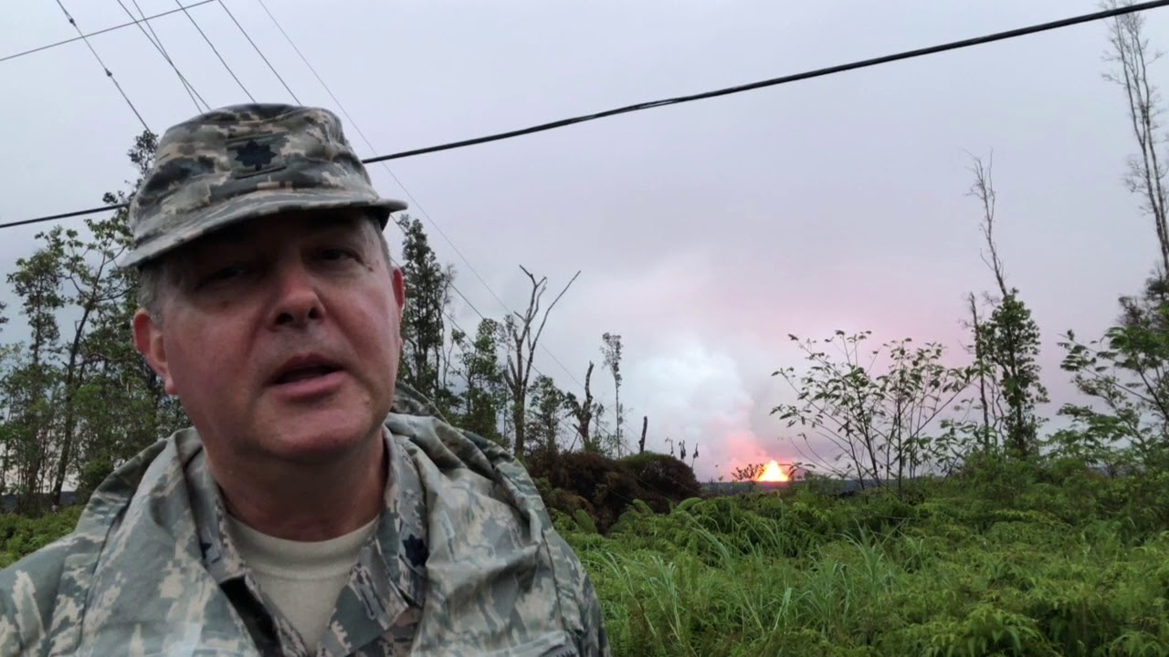
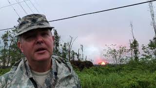
>> Hawaii Army National Guard update on fissure 8, June 5
>> Flyover of lava entering Kapoho Bay, June 4
>> A look at damage to the Hawaii Volcanoes National Park after earthquake, June 4
>> Flyover of fissure No. 8 in Leilani Estates, June 2
>> Emergency lava route through Chain of Craters-Kalapana Road nearly complete, June 1
>> Pyroclasts inundate Leilani Estates as lava continues to flow, May 31
>> Leilani Estates residents talk about evacuating as lava advances, May 31
>> Aerial view of lava flow in Leilani Estates, May 29
COMPLETE KILAUEA COVERAGE
>> Star-Advertiser volcano coverage
>> Kilauea Volcano YouTube playlist
“It looks like there’s no stopping,” said Talmadge Magno, Hawaii County Civil Defense administrator.
Carolyn Boudreault, an eight-year Kapoho resident who fled back to a family home in Boston about three weeks ago, said the bay filled with tide pools was a special place.
“It’s a beautiful spot,” she said Monday from Boston. “Gorgeous.”
Boudreault said she was OK staying as long as there were two road exits out of the area. But after one of her young sons started crying during a second-grade school drawing exercise aimed at understanding lava, she and her two sons departed May 12.
“It just got to be too much,” she said, adding that her husband followed about a week later.
Magno said most residents left Kapoho before lava cut off the last road out, Government Beach Road, also known as Highway 137. Yet some remain, he said, amending a prior estimate that about a dozen people probably were isolated in the area.
“That’s probably a low number,” he said.
Magno estimated that up to 80 percent of the roughly 500 homes in the Kapoho Beach Lots and Vacationland subdivisions in Kapoho were vacation rentals.
As for those staying, Magno said county officials aren’t going to force them to leave, because they should be able to walk out along the shoreline if they are in Kapoho Beach Lots above the flow, or they possibly could depart by water.
On Sunday three people were airlifted out after a helicopter being used by USGS scientists spotted people signaling for help. One other person, who declined the same chopper ride Sunday, was airlifted by a county Fire Department helicopter Monday, Magno said.
Lava had destroyed at least 117 homes as of Monday morning, up from 87 previously. But Magno said another 42 were counted since then. “We still have a lot more to count,” he said. “(There’s) a lot of destruction going on.”
Boudreault believes her family farm was still untouched by lava Monday, but she was less sure about her home.
One dangerous byproduct of lava entering the ocean is “laze,” or lava haze, which is a mix of saltwater steam, hydrochloric acid and tiny bits of volcanic glass. USGS cautions that laze can be dangerous, especially within 1,000 feet.
“It’s pretty corrosive,” Janet Babb, a USGS geologist at the Hawaiian Volcano Observatory, said in a media conference call. “Even at the wispy edges of the plume, you can feel the effects of the laze.”
The white plume can sting skin, irritate lungs and burn eyes but does dissipate rather quickly. Hawaii County noted that the hot, corrosive gas mixture killed two people in 2000 when seawater washed across recent and active lava flows.
The lava flow that entered Kapoho Bay also has displaced a nearby lake in an ancient cinder cone called Green Mountain. The county Fire Department reported that the water in Green Lake, locally known as Ka Wai a Pele, was evaporated by lava Saturday.
At Kilauea’s summit, Hawai‘i Volcanoes National Park sustained major damage from a 5.5-magnitude earthquake that struck Sunday.
The shallow quake left cracks in the most popular part of the largely closed park.
National Park Service officials reported Monday that the park’s visitor overlook deck at Jaggar Museum sustained cracks.
The park, which in recent years has been Hawaii’s most visited tourist attraction, has been partially closed a record 25 days and has no prospect of reopening anytime soon. A lower third of the park remains open, but the upper section is where most visitors flocked to see the volcano caldera and lava in its vent from the overlook deck.
Other conditions at the park include no water because of cracked pipes and layers of acidic volcanic ash coating picnic tables, roads and overlooks.
The corrosive ash has been produced from explosions at the summit that launch rocks nearby along with ash that can rise as high as 30,000 feet.
Besides the explosions, earthquakes big and small are a nearly constant occurrence at the summit.
Over the weekend, the Hawaiian Volcano Observatory reported more than 500 shallow earthquakes in a 24-hour period — the most ever measured by HVO scientists, according to NPS.
Roads in the park are fractured, and three buildings, including the park’s visitor emergency operations center, are damaged. NPS said Crater Rim Drive and Hilina Pali Road near Kulanaokuaiki Campground are impassable in places.
Along the park’s eastern shoreline boundary, earth cracks were observed near Holei Sea Arch on a recent overflight and are of concern, NPS added.
“We understand and commiserate with our community and visitors about the prolonged closure, but we cannot provide safe access to the Kilauea section of the park as long as these very unpredictable dangers threaten the safety of park staff and visitors,” park Superintendent Cindy Orlando said in a statement. “Unlike lava, which you can see coming and avoid, we cannot see or predict earthquakes, nor can we foresee a summit explosion, but both threats continue.”
Park officials invite visitors to see the section of the property that remains open, and to visit rangers who have been deployed to other places to help people experience what is going on at the park even though they can’t be there.
The “Kahuku Unit” of the park, which is an hour south of the main entrance on Highway 11 near mile marker 70.5, is open Wednesday through Sunday from 9 a.m. to 3 p.m.
However, this part of the park that is popular for its hikes can be affected by poor air quality depending on wind direction.
Park rangers and volcano displays are also at the Mokupapapa Discovery Center, a marine museum, in downtown Hilo, Tuesday through Saturday from 9 a.m. to 4 p.m. Starting today, rangers are at the Volcano Art Center’s Niaulani Campus in Volcano village from 9 a.m. to 4 p.m. Rangers are also at the Hilo Airport most days and at the Naniloa Hotel Sundays and Mondays to answer questions about the park and current eruption conditions.


