Hurricane Hector continues on westward track away from isles

CENTRAL PACIFIC HURRICANE CENTER
The five-day forecast for Hurricane Hector as of 11 a.m. Thursday.

COURTESY NATIONAL OCEANIC AND ATMOSPHERIC ADMINISTRATION
A composite of satellite images over a 7 1/2-hour period ending at 4:30 a.m. today shows the position of Hurricane Hector relative to Hawaii.

COURTESY CENTRAL PACIFIC HURRICANE CENTER
The five-day forecast of wind probabilities for Hurricane Hector as of 5 p.m. Wednesday.
UPDATE: 11 a.m.
Hector continues to move away from Hawaii and is still a major hurricane.
Located 385 miles southwest of Honolulu, Hector remains a Category 3 hurricane with maximum sustained winds of 120 mph and is moving west at 16 mph, according to the Central Pacific Hurricane Center.
Weather officials forecast Hector to hold to its current course through most of today, with a gradual turn toward the west-northwest tonight through late Friday. Slow weakening is expected to restart Saturday.
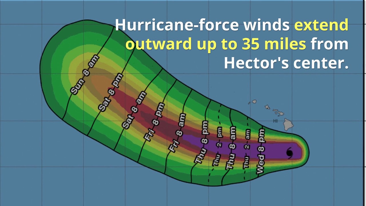
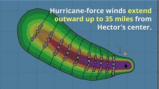
Hurricane-force winds extend outward up to 35 miles from Hector’s center and tropical-storm-force winds extend outward up to 90 miles.
PREVIOUS COVERAGE
Although it’s hundreds of miles south of Hawaii, Hector is still a major hurricane and is whipping up the seas and wind around the islands.
Packing maximum sustained winds of 120 mph — 5 mph higher than Wednesday night — Hector was located 355 miles south-southwest of Honolulu and headed west at 16 mph at 5 a.m. today, according to the National Weather Service.
Hurricane-force winds extend outward up to 35 miles from Hector’s center and tropical-storm-force winds extend outward up to 90 miles.
The Category 3 hurricane is expected to maintain its strength through Friday as it heads toward Johnston Island, weather officials said.
The following advisories and warnings are in effect:
>> A hurricane warning for Hawaiian offshore waters beyond 40 nautical miles out to 240 nautical miles including the portion of the Papahanaumokuakea Marine National Monument east of French Frigate Shoals. Seas 15 to 30 feet in southern waters. Elsewhere, and northeast winds of 15 to 25 knots and seas of 8 to 15 feet. Scattered thunderstorms in southern and southeast waters.
>> A gale warning for Pailolo and Alenuihaha channels and Maalaea Bay through 6 a.m. Thursday. Northeast winds of 25 to 35 knots and seas of 8 to 13 feet are expected in affected areas.
>> A small craft advisory remains in effect for waters from Kauai to Windward Maui through 6 a.m. Thursday. Northeast winds of 15 to 25 knots and seas of 7 to 11 feet are expected in affected areas.


