Lane continues to weaken as it moves away from Hawaii


CENTRAL PACIFIC HURRICANE CENTER
Here is the 5-day forecast track for Tropical Storm Lane as of 11 p.m. Saturday.

ASSOCIATED PRESS
In this photo provided by Jessica Henricks, is flooding and damage from Hurricane Lane on Friday near Hilo, Hawaii. Hurricane Lane barreled toward Hawaii on Friday, dumping torrential rains that inundated the Big isle’s main city as people elsewhere stocked up on supplies and piled sandbags to shield oceanfront businesses against the increasingly violent surf. The city of Hilo, population 43,000, was flooded with waist-high water.

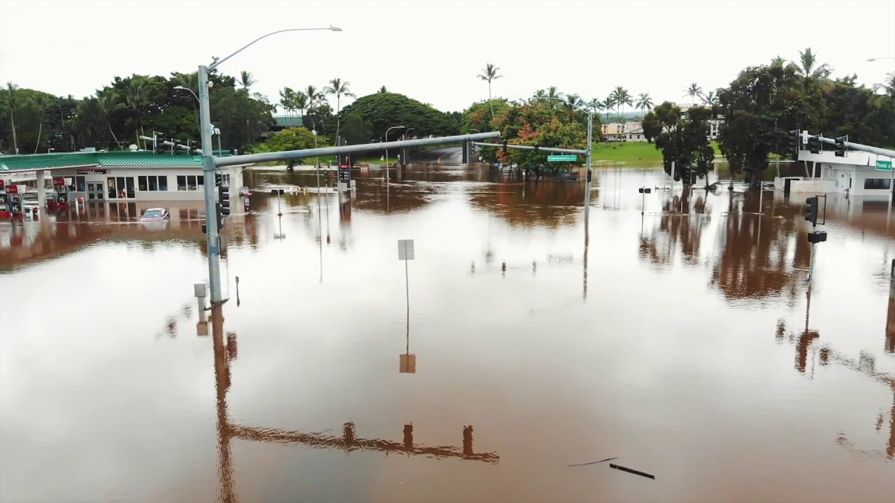
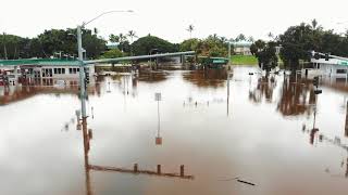
COURTESY TRACEY NIIMI
Drone footage provided by Tracey Niimi showed flooding at Pauahi Street and Kamehameha Avenue in Hilo near Bayfront Highway. Rain from Hurricane Lane flooded parts of the Big isle.

ASSOCIATED PRESS
This photo provided by Jessica Henricks shows damage from Hurricane Lane on Friday near Hilo, Hawaii. Hurricane Lane barreled toward Hawaii, dumping torrential rains that inundated the Big isle’s main city as people elsewhere stocked up on supplies and piled sandbags to shield oceanfront businesses against the increasingly violent surf. The city of Hilo, population 43,000, was flooded with waist-high water.

JAMM AQUINO / JAQUINO@STARADVERTISER.COM
Kailua-bound Pali Highway remains closed this morning Saturday, Aug. 25.

JAMM AQUINO / JAQUINO@STARADVERTISER.COM
A bodyboarders braves leftover storm surge and waves from Tropical Storm Lane at Makapuu Beach on Saturday, Aug. 25.

UPDATE: 11 p.m.
Tropical Storm Lane continues to weaken and move away from Hawaii, last located about 255 miles west-southwest of Honolulu and 220 miles south-southwest of Lihue.
Lane is moving toward the west near 8 mph, which is expected to continue into Monday before it accelerates northwestward by Tuesday.
“Some weakening is forecast during the next 48 hours, and Lane is expected to become a post-tropical low on Monday,” forecasters said.
Maximum sustained winds are near 40 mph with higher gusts. Tropical-storm-force winds extend outward up to 70 miles from the center.
8 p.m.
The flash flood warning has been extended for the Big Island unti 11 p.m.
At 7:27 p.m., the National Weather Service reported heavy rain over the lower Puna District.
“The most intense rainfall of 2 to 4 inches per hour was around Pahoa and Hawaiian Beaches, extending along Highway 130 toward Hawaiian Paradise Park,” forecasters said. Flash flooding is occurring in this area.
More rain is expected to move over the east-facing slopes of the Big Island through tonight.
Locations in the warning include but are not limited to Hilo, Hawaiian Acres, Orchidlands Estates, Glenwood, Pepeekeo, Keaau, Hawaii Volcanoes National Park, Volcano, Laupahoehoe, Wood Valley, Hawaiian Paradise Park and Pahoa.
5 p.m.
Tropical Storm Lane continues to move west and away from the main Hawaiian islands.
Lane is moving toward the west at 9 mph and this motion is expected to continue through Monday with a slight increase in forward speed. It’s located 195 southwest of Honolulu and 180 miles south-southwest of Lihue.
The storm has maximum sustained winds of about 50 mph with higher gusts and tropical-storm-force winds reaching outward up to 100 miles.
Lingering moisture from Lane will produce excessive rainfall over the state through Sunday, which could lead to additional flash flooding and landslides.
A flash flood warning is in effect for Hawaii island until 8 p.m. A flash flood watch remains in effect for the entire state through Sunday afternoon.
11:15 a.m.
A tropical storm warning has been canceled for Oahu and Maui, and a tropical storm watch has been canceled for Kauai, the National Weather Service said.
Tropical Storm Lane is moving westward at about 7 mph and is expected to pick up speed. It is expected to pass about 150 miles south of Kauai today.
The storm has maximum sustained winds of about 50 mph with higher gusts and tropical-storm-force winds reaching outward up to 100 miles.
It is about 145 miles southwest of Honolulu.
The weather service said lingering moisture from the storm is expected to produce additional flash flooding and landslides, with additional amounts of 5 to 10 inches of rain across the windward side of Hawaii island and Maui and 3 to 5 inches elsewhere.
10:47 a.m.
The National Weather Service issued a flash flood alert for all Hawaiian islands from now until later tonight.
A flash flood watch is now in effect for Oahu, Hawaii island, Kauai, Lanai, Maui, Molokai and Niihau.
Hawaii residents should prepare for heavy rainfall, including amounts greater than 20 inches in some areas.
Avoid crossing fast-flowing water, the alert warned. “Monitor later forecasts and be prepared to take action should flash flood warnings be issued. If you experience heavy rain or rising water, head to higher ground immediately,” NWS said.
5 a.m.
The National Weather Service Central Pacific Hurricane Center this morning canceled the tropical storm warning for Hawaii island, but the island continued to be under a flash flood warning.
Hawaii island, which struggled with enormous rainfall on the windward side of the island, continued to see heavy rain this morning. The tropical storm warning remained in effect for Oahu and Maui counties. Kauai county was still under a tropical storm watch.
Tropical Storm Lane was located about 110 miles south-southwest of Honolulu and about 165 miles south-southeast of Lihue, according to NWS. Lane was moving slowly at about 3 mph to the south of the western Hawaiian isles with maximum sustained winds of 60 mph with higher gusts.
Forecasters said the motion would continue through this morning, followed by a turn toward the west later today or tonight. “On the forecast track, the center of Lane will pass south of Kauai and Niihau later today and tonight,” the forecast said.
Tropical storm-force winds extend outward up to 125 miles from Lane’s eye. “Tropical storm conditions are still expected in and near outer rain bands that will affect Oahu and Maui County today,” the forecast said. Starting later today, Kauai residents may also see tropical storm conditions.
The forecast warned of excessive rainfall this weekend, which could lead to flash flooding and landslides. Some areas may receive 5 to 10 inches of rain. “Remain well guarded against life-threatening flood waters having possible extensive to devastating impacts,” the NWS said.
All major highways reopened on Big isle, including both lanes of Highway 11 in the Kawa area. The Hawaii Police Department warned Hawaii island residents to drive carefully and be on the alert for debris, potholes and water ponding on roads.
A high surf advisory remained in effect for south- and east-facing shores of all islands.
PREVIOUS COVERAGE
Saturday 2:30 a.m.
Tropical Storm Lane, with maximum sustained winds of 65 mph, was 130 miles south-southwest of Honolulu and 185 miles south-southeast of Lihue, moving north-northwest at about 3 mph.
The Central Pacific Hurricane Center said this general motion is expected to continue through this morning, followed by a turn toward the west later today or tonight. “On the forecast track, the center of Lane will pass south of Kauai and Niihau later today,” forecasters said.
>> Star-Advertiser Hurricane Tracker
>> Some shopping malls closing early due to Hurricane Lane
>> Flood risk rises in East Hawaii as Hurricane Lane stalls
>> Major thoroughfares on Oahu, Big Isle, Kauai closing due to Lane
>> HECO expects Lane will prompt power outages
>> Airlines issue travel waivers for passengers
>> Last-minute shopping a challenge
>> Mayor says slow-moving storm could cause major problems
>> How to pack a disaster preparedness kit
VIDEO:
>> Pi‘ihonua Bridge in Kaumana hit with flooding from Hurricane Lane
>> Weather Channel hurricane expert has a message for residents of Hawaii
>> Hawaii residents stock up on supplies ahead of Hurricane Lane
PHOTOS:
>> Hurricane Lane causes flooding on Hawaii island
>> Hawaii residents prepare for arrival of Hurricane Lane
A tropical storm warning remains in effect for Oahu, Maui County and Hawaii island, while Kauai County is under a tropical storm watch.
Tropical storm-force winds, of 39 mph or more, extend up to 130 miles from Lane’s center.
The Big Island, which has been the hardest hit by Lane, was also under a flash flood warning until 5:30 a.m. as heavy rainfall continued overnight in the Kau and Puna districts, causing extreme flooding, according to the National Weather Service.
“This is a very dangerous situation. Do not travel due to ongoing flood impacts,” the warning said.
A flash flood watch remained in effect for the entire state through this afternoon. A high surf advisory is in effect for the south- and east-facing shores of all islands until 6 a.m.
12:20 a.m.
The flash flood warning for the Big Island has been extended until 2:30 a.m. Saturday.
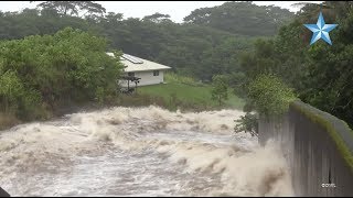
At 11:35 p.m., the National Weather Service reported extremely heavy rainfall persisting over the Kau and Puna Districts, with rates of 2 to 3 inches per hour. This has been ongoing for several hours and extreme flooding impacts are being reported by the Civil Defense.
Numerous road closures are in place including Highway 11 between Keeau and Hawaiian Paradise park, near Pahala at Kawa Flats, and on portions of Saddle Road.
Friday 11 p.m.
Tropical Storm Lane continues to flood the Big Island, prompting a number of road closures due to landslides and debris.
The Hawaii Police Department is advising residents to stay off all roadways due to the hazardous conditions. Crews are not able to open them at this time.
The Central Pacific Hurricane Center tracks Lane moving north-northwest near 3 mph south of the islands. The tropical storm was last located about 135 miles south-southwest of Honolulu and about 190 miles south-southeast of Lihue.
Forecasters said Lane is expected to turn westward beginning Saturday when it will pass south of Kauai and Niihau.
Maximum sustained winds are near 65 mph with higher gusts. Tropical-storm-force winds extend outward up to 130 miles from the center. Additional weakening is forecast through this weekend, and Lane may become a remnant low by Sunday.
Lane has dumped nearly 3 feet of rain on parts of the Big Island over the past couple of days, forcing residents to flee their homes in waist-high water.
Honolulu Mayor Kirk Caldwell said people need to be vigilant and not let their guard down. But he was happy to hear the storm deteriorated.
“The good news is Lane got weak and fell apart. We dodged a bullet,” he said at a news conference today.
Federal Emergency Management Agency officials said about 2,000 people were in shelters, mostly in Oahu. Honolulu’s shelters would stay open until midday Saturday, Caldwell said.
On Moloaki, a flood advisory is in effect until midnight, as moderate to heavy rain falls at rates of 1 to 2 inches per hour, leading to “localized nuisance flooding,” forecasters said.
8:50 p.m.
Tropical Storm Lane is nearly stationary and bringing rain and damaging winds to parts of the islands, said National Weather Service forecaster Tom Birchard.
He said the storm is in the same place it was four hours earlier with the same maximum sustained winds of about 70 mph. The center is about 150 miles south-southwest of Honolulu.
Lane is forecast to continue “wobbling” around close to the islands tonight and turn toward the west on Saturday, Birchard said.
Meanwhile, heavy rain continued falling on the Big Island with rates of 4 inches per hour at about 8:50 p.m., the weather service said.
A flash flood warning for the entire island has been extended to 11:45 p.m.
Hawaii County Civil Defense urged residents to stay off all roadways and said flooding, landslides, and debris were causing multiple road closures.
“Police report extremely dangerous driving conditions throughout the island,” a Civil Defense statement said.
Civil Defense noted that sandbags cannot be distributed because crews were responding to life-saving tasks.
The Associated Press contributed to this report.


