New photos, video show lava spreading on coastal plain


USGS / HAWAIIAN VOLCANO OBSERVATORY
A look into one of several skylights on the lava tube. The brightest area is the open lava stream.

USGS / HAWAIIAN VOLCANO OBSERVATORY
A section of the channelized aa lava, with what appears to be a small surge of lava moving through the channel is seen Thursday.

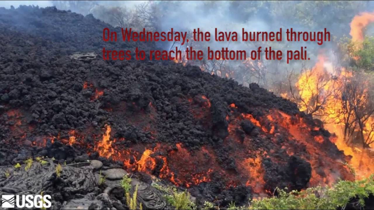
USGS / HAWAIIAN VOLCANO OBSERVATORY
The flow front reached the base of the pali Wednesday, and began spreading out a short distance onto the coastal plain on Thursday. Channelized aa lava remains active on the steep portion of the pali, with several parallel channels of swiftly moving lava.

NASA
This satellite image was captured on Monday by the Advanced Land Imager instrument onboard NASA’s Earth Observing 1 satellite. The image is provided courtesy of NASA’s Jet Propulsion Laboratory. Although this is a false-color image, the color map has been chosen to mimic what the human eye would expect to see. Bright red pixels depict areas of very high temperatures and show active lava. White areas are clouds.

USGS / HAWAIIAN VOLCANO OBSERVATORY
Just above the steep section of the pali, the lava flow transitions from tube-fed pahoehoe lava to the open channels of aa lava that are feeding the flow front.

USGS / HAWAIIAN VOLCANO OBSERVATORY
Another skylight opened up in the past few days, exposing a long section of the lava stream.

USGS / HAWAIIAN VOLCANO OBSERVATORY
A view looking up the pali, with the channels feeding lava to the flow front, which is spreading out at the base of the pali in the bottom of this Thursday photograph.

USGS / HAWAIIAN VOLCANO OBSERVATORY
This map shows Kilauea’s active East Rift Zone lava flow field in relation to the southeastern part of the island of Hawaii. The area of the active flow field on June 23 is shown in pink, while widening and advancement of the active flow field as mapped on June 28 is shown in red. The blue lines show the path of steepest descent to the ocean.
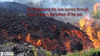
Lava from Kilauea volcano’s Puu Oo vent is starting to spread out on the coastal plain of Hawaii Volcanoes National Park, a little more than 2 miles from the ocean.
New photos and video released by the Hawaiian Volcano Observatory show aa lava following several channels down the steep slope of the pali and slowing as the flow spreads on the flat ground of the plain, covering previous lava flows.
The lava advanced about 492 feet on the plain since it reached the bottom of the pali Wednesday afternoon.
Hawaii County opened a lava viewing and parking area Thursday night that allows visitors to park at the end of the paved road in Kalapana and walk 3 miles along a gravel emergency access road to the entrance of the Hawaii Volcanoes National Park.
The flow is within the park and is about 2 miles above the road.
The park service is keeping the road closed in the park to preserve its use as an emergency road, a spokeswoman for the park service said.
The flow is also visible in the distance from scenic outlooks on Chain of Craters Road, the park service said.
It is possible to hike to the lava in the park, but officials warn that the hike is not for beginners and goes over sharp, hardened lava. It is also dangerous to get close to the lava flow, officials warned.
The current flow began on May 24 and has traveled about 4.7 miles from its origin on the east slope of the Puu Oo vent.
The photos taken Thursday also show skylights above lava tubes that have developed along the flow. The tubes keep the lava hot and flowing until the lava breaks the surface above the pali as smooth, slow-moving pahoehoe lava, which becomes rocky, fast-flowing aa lava as it tumbles down the steep pali in channels.
The last lava flow to reach the plain and the ocean, the 2011 Peace Day flow, flowed into the sea for several months from November 2012 to the beginning of 2013.
Scientists said the current flow could also reach the ocean, but lava flows are notoriously unpredictable and the flow could also stop and stall before reaching the sea.
One response to “New photos, video show lava spreading on coastal plain”
Leave a Reply
You must be logged in to post a comment.


Makes you want to fly over to the Big Island with your keikis and see this spectacle. But the truth is you’ll never get as close as the NEW PHOTOS show. Incredible large numbers of photos. You’ll have to trespass to see what the geologists get an exclusive trip to remember. If you got the money try taking a night helicopter tour. That will make it all worth the money you spend. Hawaii got a special attraction like no other in the USA. Come on over y’all. We’re the 50th State.