LIVE BLOG: USGS webcam offers live view of Mauna Loa eruption

COURTESY USGS
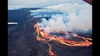
A new webcam was installed near Fissure No. 3 to stream live views of the Mauna Loa eruption, Dec. 3.

COURTESY USGS
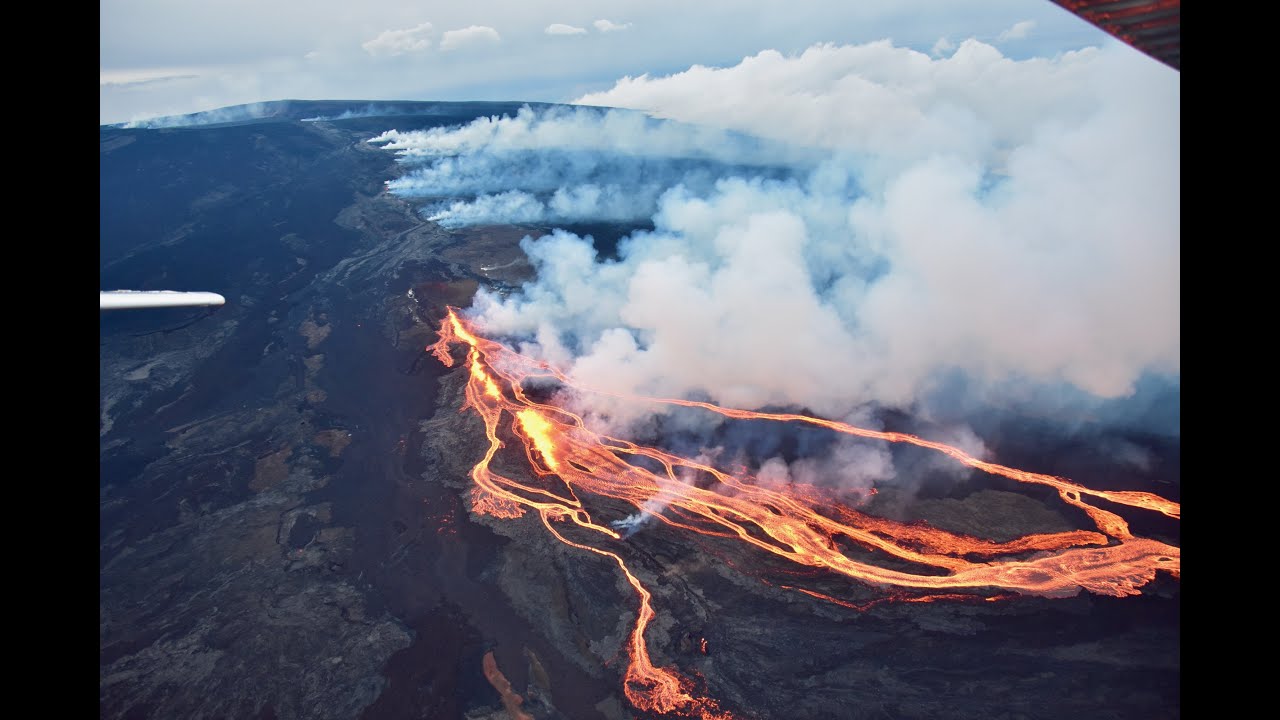
View of Fissure No. 3 erupting high on the northeast rift zone of Mauna Loa, Dec. 3.

GREGORY BULL / AP
Lava flows from the Mauna Loa volcano Friday, Dec. 2, near Hilo, Hawaii.
Editor’s Note: Bookmark this page! This story is developing and will be updated as soon as more information becomes available.
____
UPDATE 3 p.m.
The leading edge of the lava flow closest to the Daniel K. Inouye Highway remains at about 2 miles away from the highway and at about 7,000 feet in elevation, the Hawaii County Civil Defense Agency reported. The flow continues to have “minimal movement,” the agency said.
Motorists on the highway should expect and plan for delays between the 28 and 34 Mile Markers. The speed limit near the Mauna Kea Access Road and Gilbert Kahele Park has been reduced to 35 mph.
The Hawaiian Volcano Observatory reported that there is one active lava flow on the northeast rift of the Mauna Loa Volcano.
UPDATE: 2:15 p.m.
Those interested in watching the eruption at Fissure No. 3 live can access a feed from the new USGS webcam above. The webcam feed went live at around noon today.
UPDATE: 10:15 a.m.
There has been little change to the northeast rift zone eruption of Mauna Loa over the past 24 hours, according to the Hawaiian Volcano Observatory.
A lava flow fed by Fissure No. 3 continues to travel north toward the Daniel K. Inouye Highway, but has slowed after reaching the flat ground. The flow was moving at a rate of about 40 feet per hour over the past 24 hours and was about 2.5 miles from the road as of 7 a.m.
As previously reported, advance rates will be difficult to predict in the coming days.
According to officials, lava flows advance more slowly, spread out and inflate when on the flat ground between Mauna Loa and Mauna Kea. It is possible that individual lobes may advance quickly before stalling. Further breakouts may occur if lava channels get blocked upslope, HVO said.

A map showing Mauna Loa eruption activity as of Saturday at 10:30 a.m.
Click here to view the map.
HVO geologists observed glowing cracks in the area of Fissure No. 4 during a monitoring flight this morning. The fissure is no longer active, leaving Fissure No. 3 as the lone source of lava flow.
Pele’s hair has now been reported as far as Laupahoehoe.
PREVIOUS COVERAGE
Mauna Loa’s historic eruption entered its sixth day today.
Two fissures were active as of Friday afternoon, with another two no longer active, according to the Hawaiian Volcano Observatory.
A cone measuring about 157 feet high was developing around Fissure No. 3, HVO said Saturday.
Fissure No. 4 remains active and is feeding lava flows toward the northeast.
Fissures 1 and 2 are no longer active.
Fissure No. 3 remains the dominant source of the largest lava flow, which is slowly creeping toward the Daniel K. Inouye Highway, also known as Saddle Road. Advance of the largest flow has slowed significantly over the past two days as lava reached the relatively flat Saddle area.
>> RELATED: Mauna Loa’s lava speed unpredictable while it creeps closer to highway
Officials Friday said advance rates could be variable as the flow moves over flat ground, meaning it will be difficult to predict if or when the flow will reach the critical transportation route. Previous estimates from HVO officials said it would take at least two weeks for the leading edge of the lava flow to reach the road.
Julia Hammer, University of Hawaii at Manoa volcanology professor, on Friday said the flow might reach the highway in five to seven days.
“But it might not even get to the road, depending on what happens upstream,” she said on the Honolulu Advertiser’s “Spotlight Hawaii” livestream program.
The lava flow’s leading edge was more than 2 miles from the highway as of this morning. It was advancing at an average rate of 150 feet per hour Friday, though its current speed has not been reported.
Julia Hammer, University of Hawaii at Manoa volcanology professor, on Friday said the flow might reach the highway in five to seven days.
Daniel K. Inouye Highway is open in both directions, though drivers should expect delays between the 28 and the 34 mile markers due to traffic. The highway’s speed limit has been reduced to 35 mph near the Mauna Kea Access Road and Gilbert Kahele Park, Hawaii County Civil Defense Agency said in a release today.
Hawaii island Mayor Mitch Roth on Friday noted the opening of a viewing area on old Saddle Road. He said and estimated 2,000 cars used the area to park Thursday night, allowing visitors to view the eruption and flow from a safe distance.

A map of the new traffic route to help mitigate traffic concerns due to the Mauna Loa eruption. Click here to view the map.
Meanwhile, the Hawaii Emergency Management Agency sent a four-person team to Hilo to assist with the county’s emergency response effort. The agency is also analyzing potential impacts to the Big Island economy, infrastructure and transportation network if the eruption were to damage Daniel K. Inouye Highway or other significant community assets.
“While the lava is moving very slowly at the moment and doesn’t pose an imminent hazard to populated areas, it’s still a hazard with huge destructive potential,” HI-EMA Administrator Luke Meyers said in a statement. “We wouldn’t be doing our jobs if we didn’t work to define the possible impacts and recommend ways to reduce or eliminate them.”
Volcanic gas plumes are lofting high and vertically into the atmosphere, generating vog in areas to the west. Pele’s hair, or strands of volcanic glass, is falling and has been reported as far the Mauna Kea Visitor Information Station.
The last measurement of sulfur dioxide (SO2) emission rates read approximately 180,000 tonnes per day on Thursday.


