Tropical disturbance threatens heavy rain for Hawaii this week
COURTESY NOAA
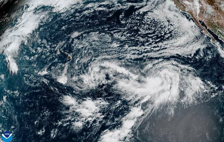
A satellite image at 9 a.m. today shows the remnants of former Tropical Depression 15-E near Hawaii, along with Tropical Storm Odalys further east.
COURTESY NHC
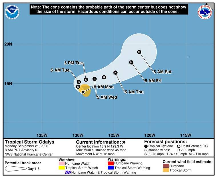
The 5-day forecast track of Tropical Storm Odalys as of this morning.
COURTESY NHC
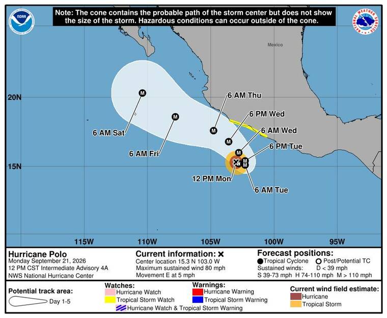
The 5-day forecast track of Hurricane Polo as of this morning.
Weather officials are closely tracking a potential tropical system lurking far southeast of the state that threatens to bring heavy rainfall to eastern portions of the islands later this week.
While uncertainty remains higher than usual, a broad area of showers and thunderstorms associated with former Tropical Depression 15-E is expected to organize during the first half of this week and advance toward the Big Island. National Weather Service forecasters in Honolulu said model simulations show a wide range of outcomes, with rainfall totals ranging from inches over a single day to totals “measured in feet over several days” if the system passes close to the state.
Forecasters may consider issuing a flood watch for the Big Island and Maui as the system approaches.
For today, a small craft advisory remains in effect until 6 p.m. Tuesday for Maalaea Bay, Pailolo Channel, Alenuihaha Channel and Big Island leeward and southeast waters. Northeast winds of 15 to 25 knots with gusts up to 35 knots and seas of 6 to 9 feet will make conditions hazardous for small vessels, the NWS said.
Breezy tradewinds will remain fresh to locally strong today, producing moderate surf along east-facing shores. South-facing shores will see above-average surf today from a long-period swell before gradually fading midweek.
Across eastern Pacific waters, two other named tropical systems are active but are not posing an immediate threat to Hawaii.
Don't miss out on what's happening!
Stay in touch with breaking news, as it happens, conveniently in your email inbox. It's FREE!
Former Tropical Storm Polo rapidly intensified into a hurricane today and was located about 270 miles south-southeast of Manzanillo, Mexico, heading east at 5 mph with maximum sustained winds of 80 mph as of 7 a.m. According to the National Hurricane Center in Miami, conditions are ideal for “explosive intensification” over very warm waters, and Polo is expected to become a major hurricane by Tuesday while remaining mostly offshore of southwestern Mexico.
A tropical storm watch is in effect for portions of the Mexican coast from Tecpan de Galeana to Punta San Telmo.
Farther west but still far from the Central Pacific, Tropical Storm Odalys is spinning over open waters about 1,415 miles west-southwest of the southern tip of Baja California, heading northwest at 12 mph with maximum sustained winds near 45 mph. Odalys is expected to turn sharply eastward Tuesday and remain over open ocean, though it could reach hurricane strength by midweek, the NHC said.
For today, the forecast for Kauai through Maui counties calls for mostly sunny and breezy conditions across most islands with highs from 85 to 90 degrees, the NWS said. Northeast tradewinds will blow at 15 to 25 mph, bringing isolated showers to windward and mauka areas. Tonight will turn mostly cloudy with scattered windward showers and overnight lows from 75 to 80 degrees.
For the Big Island, expect partly sunny and breezy conditions with highs from 89 to 94 degrees. Windward areas will see numerous showers, while leeward areas can expect scattered afternoon showers under northeast winds of 15 to 25 mph. Tonight will be cloudy windward and clearing leeward with scattered showers and lows from 73 to 78 degrees.