New lava flow approaches Puna geothermal plant


JAMM AQUINO / JAQUINO@STARADVERTISER.COM
Lava entered the ocean from the latest lava flow, today, near Pahoa on Hawaii island.

U.S. GEOLOGICAL SURVEY / CAROLYN PARCHETA
Lava flowed around a kipuka, an “island” surrounded by younger lava flows, before entering the ocean this morning in Kilauea Volcano’s Lower East Rift Zone on Hawaii island.

JAMM AQUINO / JAQUINO@STARADVERTISER.COM
Lava erupted inside Leilani Estates near fissure 17, Sunday, in Pahoa on Hawaii Island. Lava has finally reached the ocean, but experts advise exercising caution near plumes of “laze,” as they contain particles of glass as well as toxic sulphuric acid.

JAMM AQUINO / JAQUINO@STARADVERTISER.COM
A cooling lava flow that overran Highway 137 is seen Sunday in Pahoa. Lava has now reached the ocean, crossing Highway 137 late Saturday evening.

JAMM AQUINO / JAQUINO@STARADVERTISER.COM
Lt. Col. Charles Anthony with the Hawaii Air National Guard monitored sulphur dioxide levels Sunday near the lava flow that overran Highway 137 in Pahoa.

COURTESY USGS
This map shows the lava flow from Kilauea Volcano in the East Rift Zone as of 11 a.m. Sunday. The active ocean entry is shown by dots. Previous lava flows from eruptions in 1840, 1955, 1960 and 2014-2015 are shown in purple.

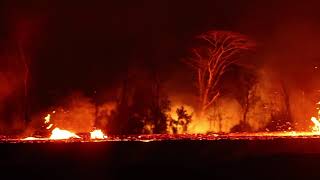
JAMM AQUINO / JAQUINO@STARADVERTISER.COM
Fissure number 17 erupts inside Leilani Estates on Saturday.

JAMM AQUINO / JAQUINO@STARADVERTISER.COM
The sky glowed orange-red Saturday from lava inside Leilani Estates in Pahoa.
UPDATE: 12:30 p.m.
Hawaiian Volcano Observatory scientists say two more lava flows are entering the ocean in Lower Puna.
The U.S. Coast Guard is enforcing a 300-meter (328 yards) safety zone from the entry areas.
Hawaii County Civil Defense officials continue to warn people south of the rift zone to be prepared to evacuate at any point and with no advance notice because of elevated sulfur dioxide levels or the threat of lava.
They also advise:
>> Kalapana and Kapoho roads are open to residents only.
>> Highway 137 is closed to all traffic between Kamaili Road and Pohoiki Road.
>> Kamaili Road is closed to all thru traffic. This is a high sulfur dioxide area.
>> Affordable rents will bring some Lower Puna residents back home
>> Big Isle leads nation in sulfur dioxide emissions
>> North Carolina sends emergency and fire officials to help in Hilo
>> Big Island family finds Tutu Pele terrifying, but merciful
>> Photos: Lava flow at Leilani Estates, May 20
>> Photos: Lava flow on Highway 137, May 20
>> Photos: Residents learn to move on under Pele’s mercy, May 20
>> Live webcam atop Halemaumau Crater
COMPLETE KILAUEA COVERAGE
>> Star-Advertiser volcano coverage
>> Kilauea Volcano YouTube playlist
10 a.m.
The lava flow moving into the ocean near MacKenzie State Park has been slowly widening, according to Janet Snyder, spokeswoman for the county.
“We have problems with people sightseeing, people parking along (Highway) 137 to look. Most people are starting to cooperate because they realize this is dangerous,” she said.
State officials announced they will expand the air quality monitoring to include hydrogen sulfide. Until now, the state monitoring efforts have been focused on sulfur dioxide.
8:45 a.m.
A relatively small lava flow has started to move in the opposite direction from the lava river pouring into the ocean along the Puna coastline, and that flow is advancing through the Puna Geothermal Venture property.
A Hawaii County Civil Defense spokeswoman said the flow from fissure 22 next to the PGV site broke out on its northwest side, and “there’s very active fountaining.”
The flow last night was approaching the well pad at PGV, but had stalled at a berm on the property, said county spokeswoman Janet Snyder.
Residents of the surrounding area have been worried that a lava flow or earthquake could damage one or more of the geothermal wells on the property, causing an uncontrolled release of potentially dangerous volcanic gases.
The wells are 6,000 to 8,000 feet deep and are used to tap into extremely hot water and steam that is used to run turbines to produce electricity. The plant has been closed since shortly after the May 3 eruption began, and PGV officials relocated 60,000 gallons of flammable pentane away from the site as a safety precaution.
There are three active wells on the PGV site, and the state has been working to “kill” those wells by pumping cold water into them, and then plan to use an iron plug to seal them.
Tom Travis, administrator of the Hawaii Emergency Management Agency, said through a spokeswoman this morning that those efforts are in the “final stages” for geothermal wells KS9 and KS6, but crews encountered difficulties with quenching another well known as KS14.
“Difficulties with quenching KS14 have led us to evaluate alternative procedures for killing the well. Preparations are being made to do that,” the spokeswoman said. No further information about the “difficulties” or the planned solution to them was available.
Gov. David Ige earlier this month issued a supplemental emergency proclamation instructing Travis, Hawaii County Mayor Harry Kim, and Hawaii Civil Defense Agency Administrator Talmadge Magno to “lead a team to develop and implement mitigation steps as necessary to protect public health and safety.”
That team includes federal and state agencies, as well as PGV, and the group was tasked with reviewing and assessing the existing PGV Emergency Response Plan as well as “develop a specific mission strategy deemed appropriate to mitigate potential impacts from lava,” according to the Ige administration.
Ige told reporters Sunday that “we are mitigating the risk to the geothermal plant and … that is an ongoing concern of ours that we want to protect the people as best as we can.”
Ige described the situation at the plant Sunday as “relatively stable.”
“The big risks have been mitigated and it’s really continuing to the original plan,” he said. “We do want to shut down the wells so that we would eliminate the broader risk of uncontrolled release.”
He described the work as “a complex operation. We haven’t done it in the past so we definitely want to be careful. We don’t want to take the risk in terms of reducing the general risk to the public and then create a different kind of exposure that didn’t exist. So, you know, we are being thoughtful. We have reached out to experts to help us through with what we’re planning to do, and they’ve been very responsive in providing their expertise.”
5 a.m.
A small explosive eruption occurred at Halemaumau crater at 12:55 a.m., according to the Hawaiian Volcano Observatory.
The resulting ash plume reached a height of 7,000 feet and was blown to the southwest by the prevailing winds. The communities of Wood Valley, Pahala, Naalehu and Waiohinu are advised that ash could be blown their way, according to the Hawaii County Civil Defense.
“Additional explosive events that could produce minor amounts of ashfall downwind are possible at any time,” the observatory said in a bulletin.
PREVIOUS COVERAGE
SUNDAY, MAY 20
11 p.m.
Hawaiian Volcano Observatory officials are monitoring two active lava flows that have entered the ocean off Highway 137 near MacKenzie State Park.
They said trade winds are pushing elevated levels of sulfur dioxide in areas downwind of lava vents, including to Kamaili, Seaview, and Malama Ki, where residents should take action necessary to limit further exposure.
As of this evening:
>> Highway 137 is closed to all traffic between Kamaili Road and Pohoiki Road.
>> Kamaili Road is also closed to all thru traffic because it is a high sulfur dioxide area.
>> Due to the lava entry at the ocean, access to the area is prohibited due to the laze hazard. The public should stay away from any ocean plume.
>> The U.S. Coast Guard is monitoring the area where lava is entering the ocean. Only permitted tour boats are allowed.
1 P.M.
The Hawaiian Volcano Observatory is warning about a “laze” plume that could reach 15 miles downwind of the lava’s ocean entry on Hawaii island’s southeast coast today.
Janet Babb, HVO spokeswoman, said the laze, short for lava haze, is formed by the reaction of hot lava coming into contact with cold seawater, producing a dense white plume of steam laced with hydrochloric acid and glass particles.
The hydrochloric acid is created by the chemical reaction between the lava and the seawater, while the glass particles are formed when lava touches seawater and shatters, similar to a glass bowl scattering glass shards when it hits the ground.
Toxins in the plume have corrosive properties akin to battery acid, and the plume should be avoided, Babb said.
The plume can irritate the skin and eyes and cause breathing difficulties.
While a store-bought respirator can block the glass particles, the respirator will not filter out hydrochloric acid, Babb said.
She said the reach of the plume depends on the vigor of the lava entering the ocean and the wind patterns, and with today’s trade winds, the plume was expected to reach 15 miles in a direction parallel to the coastline, heading slightly offshore.
Meanwhile, Wendy Stovall, a volcanologist with the U.S. Geological Survey, said lava samples from fissure 17 show it contained andesite, a rock not usually seen in volcanic eruptions in Hawaii. She said the presence of andesite means the lava that came up in fissure 17 could have come from magma stored in an underground reservoir dating back to before the 1955 eruption, possibly as early as the 1924 eruption or an eruption in 1840.
Scientists said the lava coming up in the lower East Rift Zone initially was slower moving and possibly coming from magma reservoirs stored underground since the 1955 eruption, but the lava flows reaching the ocean have a chemical signal that matches the hotter magma from Puu Oo crater and the summit, resulting in faster-moving and more voluminous lava flows.

COURTESY USGS
A laze plume appears at the lava ocean entry point today.
9 A.M.
The Hawaii Volcano Observatory is reporting that the two lava flows entering the ocean near the 13-mile marker have caused sulfur dioxide levels to triple. Hawaii County Civil Defense officials are urging people in the area to take necessary action to avoid exposure. Northeast winds are pushing laze and SO2 southwest for the time being.
The county Department of Water Supply said the lava flow that cut across Pohoiki Road also cut off the water system in the area. Two water tankers have been set up to assist those in Vacationland and Kapoho Beach Lots in need of drinking water.
The Coast Guard is setting up a buffer zone in the waters surrounding the area where the lava is entering the ocean.
7 A.M.
Quick-moving lava from Kilauea Volcano crossed Highway 137 and reached the ocean near the 13th mile marker in Lower Puna just before 11 p.m. Saturday, Hawaii County Civil Defense officials said.
In a 6 a.m. release, Civil Defense said that Hawaiian Volcano Observatory is now reporting it is a third flow front that has split into two flows which are both entering the ocean. That development is causing sulfur dioxide emissions to increase greatly and posing a health hazard, according to HVO scientists.
Highway 137, also known as the Kapoho-Kalapana, or Red, Road, was closed between Kamaili Road and Pohoiki Road, cutting off one of the access points for those living east and south of Leilani Estates. Those communities include Kehena, Kaimu and Kalapana. The residents can still leave the area through Highway 130, the Pahoa-Kalapana Road, at least for now, so a mandatory evacuation is not in place.
Nonetheless, the state Department of Transportation and National Park Service officials are working on a plan to reopen Chain of Craters Road as an emergency route out of the area. Doing so, however, would require the removal of seven-tenths of a mile of lava, which could take weeks, said Jessica Ferracane, spokeswoman for Hawai‘i Volcanoes National Park.
The Kamaili neighborhood was ordered to evacuate Saturday night due to the threat of brush fires caused by moving lava. Civil Defense officials said most people from there had previously evacuated.
Civil Defense warns that lava entering the ocean poses the issue of laze, which is formed when hot lava makes contact with ocean water, sending hydrochloric acid and steam with fine glass particles into the air Laze can cause lung, eye and skin irritation. Laze plumes travel with the wind and can change direction without warning, Civil Defense said.
The latest eruption began May 3 and has destroyed at least 44 structures, mostly in Lower Puna subdivisions including Leilani Estates and Lanipuna Gardens. Thousands have been evacuated, many to shelters set up by the American Red Cross in Pahoa and Keaau.
In the first two weeks of the eruption, lava traveled mostly below the surface, rising up out of a series of 23 fissures in the affected Lower Puna regions.
But since Friday, the lava has burst out onto the surface in vastly larger quantities and in a more fluid form, making it travel quicker. It is that type of lava, known as pahoehoe, that crossed Pohoiki road and shut off access to about 40 properties on Malama Ki Place, east of Leilani Estates, Thursday afternoon, which require four people to be evacuated by helicopter.
It is that flow that continued south through the state’s Malama Ki Forest Reserve and reached the ocean Friday night.
A separate flow moving in a more southerly direction created the brush fires threatening Kamaili.
Scientists believe the earlier fissures spit out slower, thicker and stickier a‘a lava that had been trapped underground by eruptions that occurred years ago. The faster and more fluid pahoehoe that’s been spewing since Thursday afternoon is coming from the summit.
Saturday also saw the first report of an eruption-related injury since the latest event began. Hawaii County Fire Department officials said a homeowner on Noni Farms Road was on his third-floor balcony when he got hit on the shin with lava spatter, shattering the lower portion of his leg.
“Lava bombs” can weigh as much as a refrigerator and even small pieces of spatter can be lethal, officials said.
SATURDAY, MAY 19
11 P.M.
Lava has crossed Highway 137 at the 13-mile marker and has entered the ocean, according to Hawaii County Civil Defense. A second lava flow is about 437 yards from the highway.
Highway 137 is closed between Kamaili Road and Pohoiki Road. Kamaili Road is closed between Highways 130 and 137.
Residents in the area have been evacuated and the public is asked to stay out of the area, Civil Defense officials said.
The lava has entered the ocean and the public should be aware of the laze hazard and stay away from any ocean plume, they said.
Laze is formed when hot lava hits the ocean sending hydrochloric acid and steam with fine glass particles into the air. Health hazards of laze include lung, eye and skin irritation. The laze plume travels with the wind and can change direction without warning, according to Civil Defense.
9 P.M.
The lava flow originating from fissure 20 has split into two lobes, both of which are heading toward the 13-mile marker on Highway 137.
The first flow front is about 690 yards from Highway 137 and moving about a 109 yards an hour. The second flow front is about 820 yards from Highway 137 and moving about the same speed. At the current rate, the lava may cross the highway within the next five to seven hours, according to Hawaiian Volcano Observatory scientists.
Highway 137 is closed between Kamaili Road and Pohoiki Road, while Kamaili Road is closed between Highways 130 and 137 due to a brush fire.
Residents in the area have been evacuated.
6:30 P.M.
Active lava flows have caused brush fires to spread from the flow front toward Kamaili Road. Residents on Kamaili Road need to evacuate the area immediately.
County and state fire units are in the area, going door-to-door to make sure people are informed and check if they need assistance. Everyone needs to stay clear of this area.
6 P.M.
DLNR officials have closed the Malama Ki Forest Reserve due to lava flowing into it.
The lava flow is currently heading in the general direction of MacKenzie State Park. No structures are threatened at this time.
Residents should be aware that the flow is about half a mile from Highway 137 and, at the current rate, may cross the highway within the next five to six hours.
If the lava enters the ocean, be aware of the laze hazard and stay away from ocean plume.
>> Laze is formed when hot lava hits the ocean sending hydrochloric acid and steam with fine glass particles into the air.
>> Health hazards of laze include lung, eye and skin irritation.
>> Be aware that the laze plume travels with the wind and can change direction without warning.
Due to the volcanic activity, the following are in effect:
>> Residents between Kamaili and Pohoiki are advised to decide if they want to voluntarily leave the area at this time.
>> For those who choose to voluntarily evacuate, the Pahoa Community Center, Keaau Community Center, and Sure Foundation Church are open. The shelters are pet friendly.
>> All persons are asked to avoid the area.
ROADS:
>> Highway 130 is open for residents only.
>> Closure may occur at any time with no notice.
>> Should the lava cross, Highway 137 will be closed to thru traffic.
>> Road blocks will be established on both sides of the roadway should the flow cross the highway.
5 P.M.
Civil Defense Administrator Talmadge Magno said a man suffered a “serious” leg injury this afternoon when he was “lava-bombed” by spatter while sitting on the porch of a house in an area off Highway 132 below the Lanipuna Garden subdivision.
“I heard the injury was quite bad, serious to his leg,” Magno said.
The man’s name was not released.
3 P.M.
The lava flow in state forest reserve lands is heading toward MacKenzie State Recreation Area and is less than a mile from Highway 137, Hawaii Civil Defense said this afternoon.
At the current rate, the lava may cross the highway within the next four to seven hours, Civil Defense said in its 2 p.m. update.
Residents between Kamaili and Pohoiki should now decide if they want to voluntarily leave the area.
Pet-friendly shelters are available at Pahoa Community Center, Keaau Community Center, and Sure Foundation Church.
Highway 130 remains open for residents only.
Civil Defense warned that residents should be aware of the hazard from “laze” if lava enters the ocean. Laze occurs when hot lava reaches the ocean, sending hydrochloric acid and steam with fine glass particles into the air.
1 P.M.
Lava activity was continuing in the lower East Rift Zone, while state transportation officials were working on a plan to reopen Chain of Craters Road as an emergency exit route in case Lower Puna residents are isolated by lava flows, volcano officials said during a teleconference call today.
Wendy Stovall, a U.S. Geological Survey volcanologist, said lava was shooting 90 yards into the air from a fountain at fissure 17, while lava flows from fissures 16 and 20 have merged together and are creating a voluminous line of spattering and fountaining.
She said the combined flow from fissures 16 and 20 were flowing at about 300 yards an hour at about 8 a.m., but the speed could change at any moment.
The tip of the flow was about 1.5 miles from the coastline. On Friday, the consolidated flow crossed upper Pohoiki Road and was continuing southward, the Hawaiian Volcano Observatory said.
Scientists have tested lava samples from the fissures and can say “with confidence” that magma from Puu Oo and the summit have reached the fissures in the lower East Rift Zone, Stovall said. Magma from the summit and Puu Oo is considered fresher than magma that was coming up earlier in fissures. That had been stored in the ground for decades, possibly from the 1955 lava flow. The fresher magma produces hotter lava flows that move faster and create more voluminous flows with higher lava fountains.
At Kilauea’s summit, earthquakes have subsided, but deformation continues, Stovall said.
Meanwhile, Jessica Ferracane, spokeswoman for Hawaii Volcanoes National Park, said the state Department of Transportation was working with federal and local authorities on plans to remove lava from the 2016-17 flows that is covering Chain of Craters Road to reopen the road in case highways 130 and 137 are cut off by volcanic activity.
She said about one mile of lava needs to be removed before the road will be accessible.


