New paths to wellness

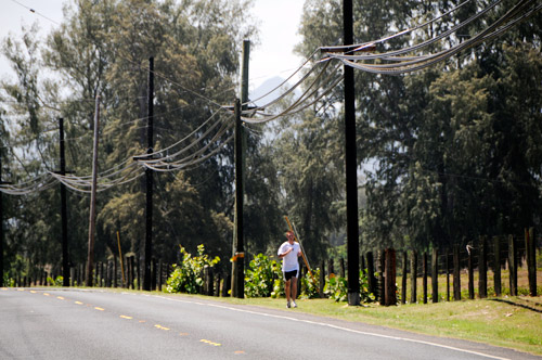
A 7,400-foot path linking Laie and Kahuku is planned for the Ko'olau Loa region mauka (mountainside) of Kamehameha Highway in Malaekahana. Above, Zach Rasmussen runs along Kamehameha Highway parallel to the proposed path, which would be on the right side of Rasmussen, inside the fence line about 20 feet.

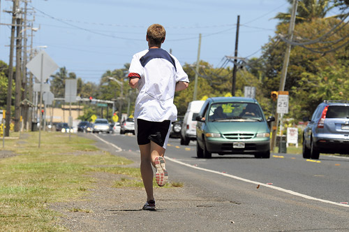
Groundbreaking begins Saturday for the Malaekahana Bike Path, which will run between Kahawainui and Malaekahana bridges, linking Laie and Kahuku. Zach Rasmussen runs along Kamehameha Highway, parallel to where the bike and running path will go.

Hawaii Reserves Inc. owns the land that will be used for a new bike and running path. Pane Meatoga, left, president of the Laie Community Association; Junior Ahyou, LCA vice president; Kevin Schlag, LCA pathway coordinator; and R. Eric Beaver, president of HRI.


On a recent morning drive here from Kahuku, Pane Meatoga’s truck passed two women, both jogging while pushing baby strollers along the narrow bike lane hugging Kamehameha Highway.
"I saw that and my heart skipped a beat," said Meatoga, president of the Laie Community Association. "There’s a big safety issue."
For the last several years, Koolau Loa area residents have chipped away at various plans to move pedestrians and cyclists a safer distance from the rural stretch of highway, where in some spots there’s little more than an arm’s length of separation from traffic.
Now, with groundbreaking for the Malaekahana Bike Path slated for Saturday, they’re excited about finally picking up shovels to start chipping away at patches of grassy debris dotting the new and safer path that is set more than 15 feet from the highway.
The meandering 8-foot-wide asphalt path — nearly 1 1/2 miles long — will run between Kahawainui and Malaekahana bridges, linking Laie with Kahuku. A 5-foot tall fence will go up along the path’s mauka side to keep out wandering cattle and horses from nearby pastures.
Organizers hope the safer path will encourage more people to leave their cars at home for short trips between the two communities and step up exercise routines. The area is home to a sizable native Hawaiian and Pacific Islander population, two groups at higher risk for obesity and diabetes.
Don't miss out on what's happening!
Stay in touch with breaking news, as it happens, conveniently in your email inbox. It's FREE!

The land is owned by Hawaii Reserves Inc., which manages or owns properties affiliated with the Church of Jesus Christ of Latter-day Saints, including about 7,000 acre in Laie. HRI will retain ownership of the land and provide construction materials for the project. Laie and Kahuku community associations and other volunteers will install and maintain the path.
"It’s going to take a lot of coordinating," Meatoga said, noting he intends to recruit volunteers ranging from student athletes who have long used the existing bike lane for conditioning workouts to skilled craftsmen and landscapers. With an ample and enthusiastic volunteer turnout, Meatoga said construction could wrap up within three months.
The Malaekahana Bike Path is the first green-lighted project generated by Envision La’ie, an ongoing private-public effort to map a 50-year sustainability plan for the Koolau Loa region focusing on affordable housing, jobs and education.
"We think the bike path is going to be a great benefit," said R. Eric Beaver, HRI’s president and chief executive officer. The mauka-side buffer from the highway will prompt more families to send kids to school on foot or bicycles, and parents will no longer have to drive on the highway to get them to campus, he said.
Regarding Envision La’ie, Beaver said the community partnership assembling to build the path marks "the beginning of what we think is the fulfillment of that vision."
Other proposed roadway projects include upgrading bike lanes along main streets in Laie and revamping the Malaekahana area’s old Cane Haul Road as a viable alternative north-south route to Kamehameha Highway.
Ralph Makaiau, president of the Kahuku Community Association, sees the push for sustainability — embraced by HRI, Brigham Young University-Hawaii, the Polynesian Cultural Center and local groups — as a chance to dictate "inside-out" controlled growth, rather than having outsiders, such developers and builders who live elsewhere, call the shots.
In addition to signing up for shifts on the Malaekahana Bike Path construction crew, Kahuku association members are looking into ways to secure land for a similar path that would connect Kahuku to the Turtle Bay resort area.
‘"’Envision,’" in our opinion, is the people wanting to do for themselves, help themselves," Makaiau said. "At this point, the call has gone out and Kahuku has responded. We want to help, we want to participate."
Maureen McConnell is a Honolulu-based freelance writer.
BICYCLE/PEDESTRIAN PATHS IN HAWAIIOAHU North Shore Honolulu Leeward Windward BIG ISLAND MAUI KAUAI ON THE NET Source: Bike Plan Hawaii (2003), Hawaii Department of Transportation, www.hawaii.gov/dot/highways/Bike/bikeplan Opens in a new tab; Hawaii Bicycling League, www.hbl.org Opens in a new tab; PATH (People’s Advocacy for Trails Hawaii), www.pathhawaii.org Opens in a new tab.; Kauai Path, Inc., kauaipath.org Opens in a new tab; Maui Bicycle Alliance; National Park Service Rivers, Trails & Conservation Assistance Pacific West Region Honolulu Office.
RULES OF THE ROAD » Be courteous. Respect other users regardless of mode of travel, speed or skill level. Source: Maui Bicycle Alliance, Kauai Path Inc., Hawaii Bicycling League
|


