Flood watch expanded, extended to include Oahu

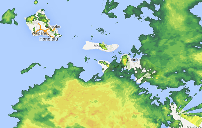
This radar image shows heavy rain over parts of Oahu, Maui County and the Big Island at about 7:30 a.m. Saturday.

Hurricane Ana swung its way south of Hawaii Island on Friday morning. Surfers and onlookers came out to watch the high surf at Pohiki Beach.

Hurricane Ana swung its way south of Hawaii Island on Friday morning. Isle residents arrived early to the Red Cross Shelter at the Pahoa HIgh School gym.
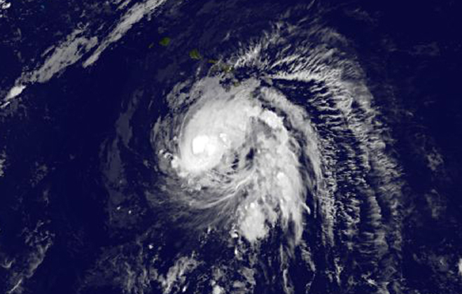
This image provided by NOAA shows tropical storm Ana taken Saturday Oct. 18, 2014 at 2:00 a.m. EDT. The National Weather Service said Friday that Ana became a Category 1 hurricane about 230 miles south of Hilo with maximum sustained winds of 80 mph. It was churning along its course at 13 mph. The hurricane was expected to gradually weaken to become a tropical storm again by early Sunday morning, Chris Brenchley, a weather service meteorologist said. The center of the powerful Pacific storm was expected to remain 150 miles away from the Big Island as it passed late Friday night. (AP Photo/NOAA)
The National Weather Service issued a second flash flood warning for Hawaii island and expanded and extended a flood watch to all islands as Hurricane Ana, passing far to the south, brought heavy rain to parts of the state.
The National Weather Service issued another flash flood warning for Hawaii island until noon as a rain gauge at Kulani Cone above Glenwood showed rain falling at a rate of 2 inches an hour at 9 a.m. The rain was expected to continue over the Kau and Puna districts.
At 7 a.m. Saturday, the National Weather Service said an area of heavy rain over the southern end of the Big Island was nearly stationary and had caused flash flooding on the Mamalahoa Highway near Kawa Flats. The warning includes Wood Valley, Pahala, Punaluu Beach and Punaluu and is in effect until 10 a.m.
The flash flood watch for the state is in effect until 6 p.m. Previously, only the Big Island was under a flood watch.
At about 8 a.m. Saturday. Ana’s winds remained at 80 mph with higher gusts. The category 1 hurricane was 165 miles south-southwest of Honolulu and 215 miles south-southeast of Lihue, moving to the northwest at 13 mph. The tropical storm force winds extend 105 miles from the center and hurricane force winds extend out 25 miles.
The National Weather Service dropped tropical storm watches and posted high surf advisories for Hawaii island and Maui County and added a high surf warning for west shores of the Big Island. A flash flood watch for the Big Island is scheduled through noon Saturday.
Don't miss out on what's happening!
Stay in touch with breaking news, as it happens, conveniently in your email inbox. It's FREE!
Forecasters said tropical storm conditions, although not likely, are still possible for Oahu and Kauai counties, which are also expecting warning-level surf on south shores.
Ana is expected to remain a hurricane as it passes south of the main Hawaiian islands Saturday. The storm is moving quickly and expected to pass about 160 miles south of Oahu and Kauai County Saturday night.
Ana is far enough south to avoid the strongest hurricane winds, but the storm is still expected to bring heavy rains, gusty winds and dangerous surf.
Forecasters said the west side of the Big Island, which is under the high surf warning, could see waves with 8 to 12 foot faces Saturday until 6 p.m. South-facing shores of Hawaii island and Maui County are under a high surf advisory.
The rough surf — with wave faces of 10 to 15 feet — are expected to reach southern shores of other islands Saturday.
On Oahu, Mayor Kirk Caldwell urged people to postpone ocean and mountain outdoor activities until the waves and rain drop off.
Even as the center of the hurricane moved southwest of Kailua-Kona, the outer bands were still bringing heavy rain to the island and strong winds to Big Island summits.
Mauna Kea and Mauna Loa summits were under a wind advisory as southeast winds of 30 to 45 mph lashed the mountain tops with gusts of over 65 mph.
At 4:15 a.m. moderate to heavy rain was falling over portions of the Big Island, with the most heavy rain hitting the Kau district near Pahala.
Earlier in the morning, at 1:18 a.m., rain gauges were recording rain rates of 1 to 2 inches an hour over North Kohala.
Earlier Friday night, Wood Valley was getting hit with rainfall at the rate of 2 to 3 inches per hour.
At 10:30 p.m., moderate to heavy rains associated with Ana hit Glenwood and Mountain View in upper Puna and in lower South Kohala.
On Oahu,, heavy rain, falling at a rate of 2 inches an hour, just before 1 a.m., at Manoa’s Lyon arboretum prompted forecasters to issue a flood advisory for Oahu, which expired at 3:45 a.m. Radar also showed heavy rain along the Koolaus from Punaluu to Waimanalo, with some of the rain drifting into leeward urban areas.
The latest forecast track keeps Ana’s path to the south, with all islands out of range for a direct hit.
But foreasters caution that people should not focus on the exact track of the storm.
“Only a slight shift to the right (closer to the Hawaiian islands) in the forecast track could mean signficant differences in the potential impacts to the main Hawaiian islands,” forecasters said.
A high pressure ridge developing near Oahu and Kauai is likely to cause Ana to slow down and turn to the west, keeping the storm south of the islands.
The forecast for southern shores of Oahu, including Honolulu, calls for frequent showers and the chance of thunderstorms through Sunday. Winds of 15 to 20 mph, with higher gusts are possible through Saturday night as Ana passes south of the island. The chance of rain is 90 to 100 percent through Monday.
Maui and Kauai counties can expect similar weather, with the timing sooner for Maui and later for Kauai, as Ana makes its closest approach to those islands.
Ana will likely leave muggy Kona weather and showers in its wake as it moves northwest away from the state. The humidity, southeast winds, and rainy weather could stick around through the end of next week.


