Dolores reaches hurricane strength in the Pacific

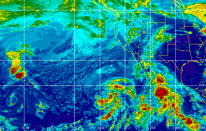
This satellite image taken Monday morning shows newly-formed Tropical Storm Enrique in the East Pacific and Tropical Storm Dolores near the Mexican coast. Near Hawaii, what's left of former Tropical Storm Ela is northwest of the islands. Tropical Depression Iona is southwest of the islands, showing little thunderstorm activity. Tropical Storm Halona has moved out of the Central Pacific and was near the International Dateline.
MIAMI » Dolores reached hurricane strength Monday in the Pacific Ocean, though a tropical storm watch has been discontinued for coastal Mexico.
Hurricane Dolores is expected to bring some rainfall totaling 1 to 3 inches along the southwestern coast of Mexico, with isolated amounts of up to 5 inches. But it does not pose any major threat to land.
The National Hurricane Center in Miami said Dolores is centered 190 miles southwest of Manzanillo, Mexico. It was moving west-northwest at 9 mph and had maximum sustained winds of about 75 mph.
Another system, Tropical Storm Enrique, also churned over the Pacific. It was far from land and posed no threat.
Enrique has maximum sustained winds of 40 mph. It was centered about 1,225 miles west-southwest of the southern tip of Mexico’s Baja California peninsula and is moving northwest near 12 mph.
In the East Pacific, south of Hawaii, former Tropical Storm Iune weakened to a post-tropical depression remnant low overnight. What’s left of the storm was expected to continue to weaken as it moves west, away from the state. It was 610 miles south-southwest of Lihue at 5 a.m. with maximum sustained winds of 30 mph.
Don't miss out on what's happening!
Stay in touch with breaking news, as it happens, conveniently in your email inbox. It's FREE!
Iune sent some high clouds over Hawaii, which may have cooled conditions slightly over the weekend, but had no other effect on the state’s weather.
Tropical Storm Halola is forecast to strengthen into a typhoon Monday, as it continues on a possible path to Wake Island in the Western Pacific.
What’s left of Tropical Storm Ela continued moving away from Kauai to the northwest of Hawaii. The former storm continues to dissipate, but it brought tropical moisture to the islands, rains and oppressive humidity Saturday and Sunday.


