Ignacio passing to the north, Jimena enters Central Pacific

Hurricane Ignacio is moving on a path north of the state.
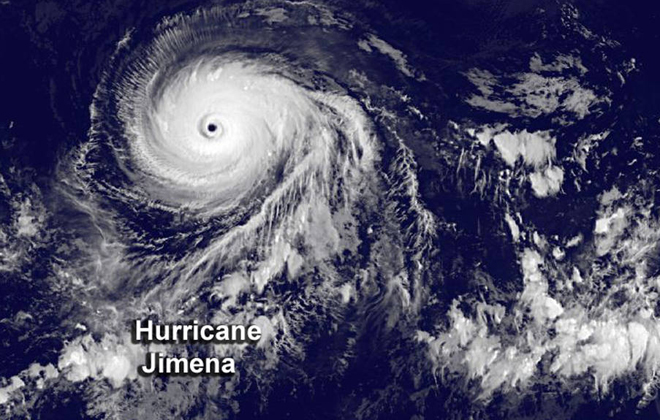
This infrared image from NOAA's GOES-West satellite shows Hurricane Jimena on Monday with a clearly-defined eye.
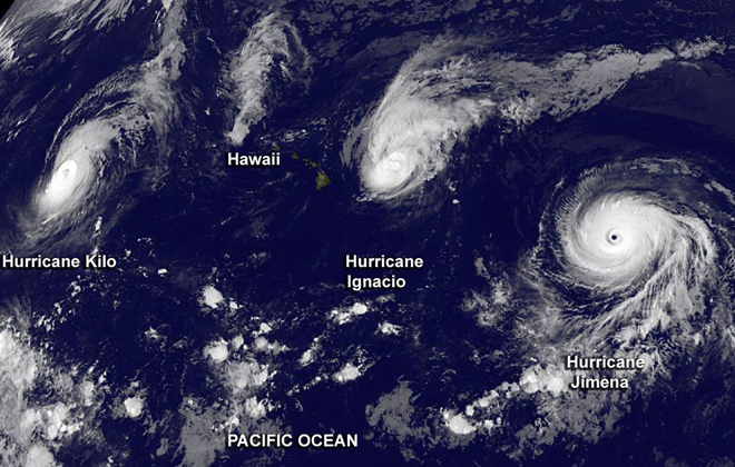
This infrared image from NOAA's GOES-West satellite shows Hurricane Kilo (left) Hurricane Ignacio (center) near the Hawaiian Islands and Hurricane Jimena (right) on Sunday.
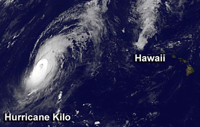
This infrared image from NOAA's GOES-West satellite shows Hurricane Kilo west of the Hawaiian Islands near the International Date Line Monday.
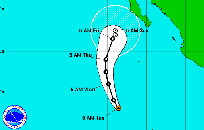
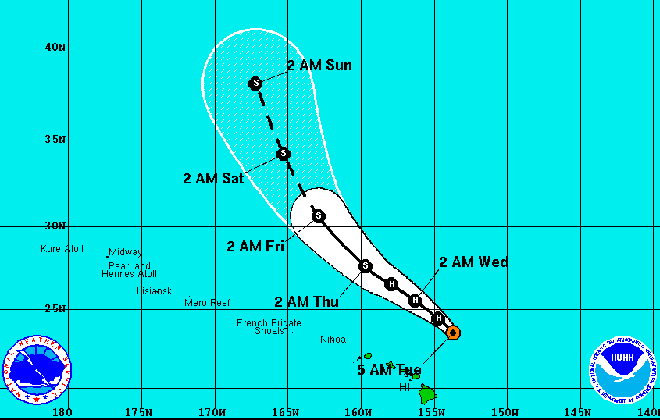
Tropical Depression 14E is on a path north to Mexico's Baja California coast.
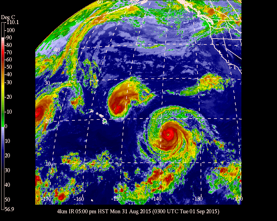
This enhanced satellite image from Monday shows Hawaii surrounded by three hurricanes, Kilo, far left, Ignacio, north of the Big Island, and Jimena, approaching the Central Pacific.
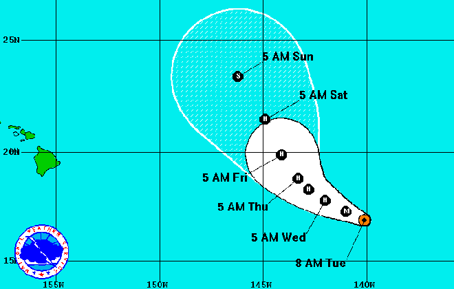
Hurricane Jimena is expected to make a sharp north turn before reaching Hawaii.
Hurricane Ignacio is bringing dangerous surf to east shores, muggy, uncomfortable weather and the chance of thunderstorms as it continues to pass north of the islands.
On the Big Island, high surf generated by Ignacio closed Bayfront Highway in Hilo between Pauahi and Waianuenue streets and beach parks at Coconut Island, Onekahakaha, Kealoha and the Bayfront canoe area.
The surf also sent sand and ocean debris over Kamehameha Highway near Kaaawa Elementary School on Oahu.
On Kauai, officials closed Poipu Beach and all east-facing beaches, from Anahola to Lydgate beach parks, because of high surf and hazardous ocean conditions.
A high-surf warning for east-facing shores is in effect until 6 a.m. Wednesday. Surf is expected to peak at 10 to 15 feet Tuesday. A reinforcement swell from Hurricane Jimena is forecast to arrive Wednesday and the high surf warning may be extended.
At 5 a.m. Tuesday, Ignacio was about 310 miles east-northeast of Honolulu and 275 miles north-northeast of Hilo, moving northwest at 10 mph.
Don't miss out on what's happening!
Stay in touch with breaking news, as it happens, conveniently in your email inbox. It's FREE!
Maximum sustained winds of 80 mph continue to weaken. The hurricane-force winds extended 35 miles from the center and tropical storm-force winds extended 175 miles.
Ignacio should be a tropical storm by Wednesday, forecasters said.
“Ignacio will pass 200 to 300 miles to the northeast of all the main Hawaiian islands over the next day or so,” according to Central Pacific Hurricane Center forecasters.
Forecasters expect “very humid conditions with spotty heavy showers, mainly each afternoon,” to continue for the rest of the week even after Ignacio moves off to the north.
“Ignacio will cut off the trade winds entirely as it passes northeast of the islands through tonight,” the National Weather Service said. “Many people may find conditions uncomfortably stagnant and humid despite any wind that can develop in this environment.”
Winds are expected to be light and from the south.
Hurricane Jimena moved into the Central Pacific Tuesday morning as a Category 3 hurricane with winds of 120 mph.
At 5 a.m. Tuesday, Jimena was about 1,000 miles east of Hilo, moving west-northwest at 10 mph.
Hurricane-force winds extend outward up to 60 miles from the center and tropical storm-force winds extend up to 205 miles, according to forecasters with the National Hurricane Center in Miami.
The storm is expected weaken and turn to the north over the next two days,
Other than an increase in surf, it’s too early to tell if Jimena will pass close enough to affect Hawaii’s weather. If it takes a more northerly path, it could have very little to no effect on Hawaii’s weather. A track further to the south could bring continued muggy weather to the islands.
Kilo, the last storm to menace Hawaii, moved past the International Date Line and out of the Central Pacific overnight.
Behind Jimena, Tropical Depression 14E, the 14th tropical cyclone in the East Pacific, formed southeast of Baja California Monday.
At 5 a.m. Tuesday, the storm was about 725 miles south-southwest of Baja California, moving northwest at 8 mph, with winds of 35 mph.
The system is expected to become a tropical storm before weakening and could threaten the Mexican state of Baja California this weekend.


