Lane weakens but still could leave flooding in its wake


TIM WRIGHT / SPECIAL TO THE STAR-ADVERTISER
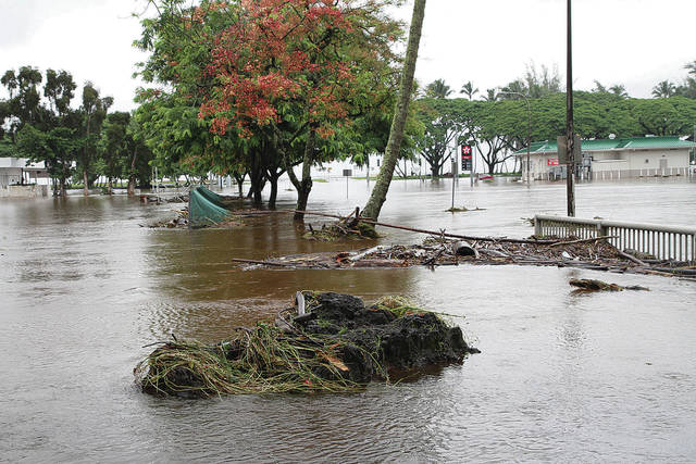
Although Lane made a dramatic exit Friday, it left parts of Hawaii island inundated with as much as 30 inches of rain. Here, Hilo’s bayfront and soccer field were lakelike Friday.

GRAPHIC BY MARTHA HERNANDEZ / MHERNANDEZ@STARADVERTISER.COM
Now Tropical Storm Lane developed into a Category 5 hurricane on Tuesday, spurring the state into action. Satellite images from NOAA show the storm moving toward the islands but breaking up Friday and downgraded to a tropical storm.


Once-powerful Lane lost its swagger Friday afternoon, starting to make its long-anticipated turn to the west after strong high-level wind shear ganged up on the top of the hurricane.
It took a while, forecaster Robert Ballard of the Central Pacific Hurricane Center said, but once 40-45 mph shear began to tear apart the core convection of Lane, the battle ended quickly.
“We will be happy to get rid of the tropical cyclone in our vicinity,” Ballard wrote in his forecast. “Until then, people should be mindful of additional impacts that can still occur until Lane departs.”
A tropical storm warning replaced all hurricane warnings.
Even though a rapidly faltering Lane lost its hurricane status, weather forecasters said the tropical storm was still packing enough punch to cause some damage across the islands.
Forecasters warned that the extremely slow-moving storm will continue to spit out rain bands with the potential to cause flooding and damaging wind to parts of the islands.
Don't miss out on what's happening!
Stay in touch with breaking news, as it happens, conveniently in your email inbox. It's FREE!
“There’s a lot of moisture out there. It’s very disorganized,” said Jerome Saucier of the Central Pacific Hurricane Center in Honolulu.
Saucier said it looks like Oahu could experience a wet weekend because the system is expected to continue crawling along between 2 and 6 mph offshore through this afternoon before picking up some speed under the influence of strong tradewinds.
Glenn James, senior weather specialist with the Pacific Disaster Center on Maui, said mighty Lane was moving along at a 16-mph clip only a few days ago, and the menacing Category 5 hurricane with sustained maximum winds of 150 mph had its sights set on the island chain.
On Friday the weakening cyclone was barely moving with high pressure to the north and low pressure to the south, and with its steering currents sheltered on the lee side of the islands by the big mountains of Hawaii island, James said.
Lane went from a Category 2 storm with winds near 110 mph to a tropical storm with sustained winds of a 70 mph in a matter of hours Friday, all the while dogged by increasing wind shear out of the southwest.
That same wind shear was a major factor in causing Lane to come to a virtual stall Friday, Saucier said.
Forecasters warned that Lane still has the potential to generate 10 to 20 inches of rain in some areas, with localized higher amounts possible with potential life-threatening flash flooding, as well as land and mudslides.
Forecasters also said swells generated by Lane will continue to generate large surf and dangerous rip currents along the south shores of all the islands, as well as cause coastal erosion. Additionally, they warned about high water levels that could overwash onto vulnerable coastal roadways through today, particularly around high tide.
What’s more, tornadoes and large waterspouts are still possible with Lane, they said.
With so much moisture in the atmosphere just south of Oahu, the potential for rainfall was expected to continue into at least Wednesday, Saucier and James said.
The assessment of this storm is far from final.
Iselle was a tropical storm when it caused $80 million in damage to Hawaii in 2014. The difference, Saucier said, is that Lane failed to make landfall and is now expected to limp away to the west.
Nevertheless, Lane caused some serious flooding damage on Maui and especially the Big Island, whose windward side saw approximately 30 inches of rain over 36 hours.


