Third lava flow reaches ocean as Kilauea keeps pumping

COURTESY U.S. GEOLOGICAL SURVEY
Geologists said lava from fissures 6, 13 and 22 was flowing into the ocean at three points Thursday.

COURTESY USGS
This U.S. Geological Survey map shows the lava activity as of noon Wednesday. On the main map, light purple areas indicate lava flows erupted in 1840, 1955, 1960 and 2014-2015. On the inset map, the dark purple area indicates locations of Kilauea Volcano’s East Rift Zone, Southwest Rift Zone and summit.

GEORGE F. LEE / GLEE@STARADVERTISER.COM
Area residents watched and recorded video as Kilauea Volcano continued its fiery show, throwing lava several stories into the air and building cinder cones in Leilani Estates on Wednesday evening.

GEORGE F. LEE / GLEE@STARADVERTISER.COM
Kilauea Volcano shot lava several stories into the air and built cinder cones in Leilani Estates at what is now the end of Kahukai Street on Wednesday evening.

COURTESY USGS
The lava fountain from fissure 22 was not as high as several days ago, but was still erupting significant lava this morning, according to scientists from the Hawaiian Volcano Observatory.

COURTESY HAWAII NATIONAL GUARD
The left aerial photo of Leilani Estates and Lanipuna Gardens was taken by the Hawaii Air National Guard’s Eagle Vision team in May 2017, while the photo on the right was taken Wednesday at 11:21 a.m.

COURTESY USGS
Blue flames from methane gas were observed early Wednesday in cracks on Kahukai Street in the Leilani Estates subdivision.

A third lava flow was entering the ocean in Lower Puna, the latest hitting the water between Pohoiki Bay and MacKenzie State Park, Hawaii County Civil Defense officials said Thursday.
They continue to warn the public to be aware of laze (lava haze), the mixture of gas and glass particles that is created from the plumes when lava hits the water.
Hawaiian Volcano Observatory officials said the lava eruption continued Thursday in Leilani Estates and Lanipuna Gardens from fissure 22, which was feeding the two other ocean entries.
>> Blue flames from methane vents surprise scientists
>> Third lava flow reaches ocean as Kilauea keeps pumping
>> Puna family still in shock; others hold on, hoping they’ll be spared
>> Lava creeping toward Highway 132 in Lower Puna
>> Evacuation by air could have Lower Puna residents out in hours, official says
>> Volcano could dent booming tourism industry
>> Puna man ‘just wanted to live’ after nearly losing leg to lava bomb
RELATED PHOTOS AND VIDEO
>> Live webcams from Hawaii island
>> Photos: Lava in Leilani Estates, May 23
>> Photos: Lava approaches Puna Geothermal Venture, May 22
>> Photos: Pahoa community meeting, May 22
>> Video: Victor Hoapili talks as lava fountains erupt in his backyard
>> Video: Ken Szymanski talks about lava fissures in his neighborhood
COMPLETE KILAUEA COVERAGE
>> Star-Advertiser volcano coverage
>> Kilauea Volcano YouTube playlist
Also, fissure 7 reactivated Thursday morning and was fountaining lava. The flow from fissure 7 was moving east into Leilani Estates and covered Kaupili and Mohala streets, between Leilani Avenue and the fissure line.
Civil Defense officials also warned residents down-rift of the lava flows to be prepared to evacuate at a moment’s notice.
Two CH-53E Super Stallion helicopters were deployed to Hilo by the Marine Corps in support of Joint Task Force 5-0, the military effort to assist Hawaii County with the current Kilauea eruption and possible evacuations.
Each CH-53E can carry more than 50 passengers at a time. Now that Highway 137 on the coast is closed by lava flows, authorities are concerned that air evacuations may be needed if Highway 130 also becomes impassable.
“The additional helicopter support from USPACOM and MARFORPAC provides the County of Hawaii and Hawaii’s Joint Task Force-50 tremendous capability,” said JTF 5-0 commander Brig. Gen. Kenneth Hara. “We now have the capacity to evacuate all of the estimated population of Lower Puna south of the lava flow within a few hours.”
The announcement came on another active day for the lava outbreak that has inundated the Lower Puna communities of Leilani Estates and Lanipuna Gardens.
Hawaiian Volcano Observatory scientists say the eruption of lava in the subdivisions is most active in the middle portion of the fissure system, near Pohoiki Road, which is producing “the most robust eruptive activity in the Lower East Rift Zone.”
They said several fissures between Luana and Kaupili streets also reactivated and are spattering.
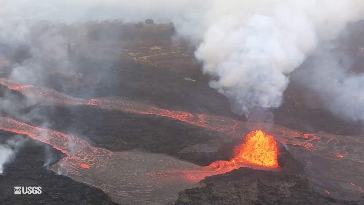
The lava fountains from fissure 22 feed a single lava channel that enters the water just north of MacKenzie State Park. Fountains are also erupting from fissures 5, 6, 13 and 19 and continue to feed a lava flow advancing to the south along the west side of fissure 22, flows that reached the ocean late Wednesday afternoon, officials said.
Volcanic gas emissions remain high from the fissure eruptions. County, state and federal crews continue to monitor the area around the shuttered Puna Geothermal Venture plant for sulfur dioxide and hydrogen sulfide gas but have not detected any of the latter.
In addition, trace ashfall over the Kau district from Kilauea Volcano was still a concern.
At the volcano’s summit, small ash emissions from the Overlook Crater continued, with ash emissions reaching 6,000 feet elevation “during the most energetic explosions … but dispersed quickly,” an HVO Thursday morning update said. “Moderate trade winds were blowing to the southwest and light ashfall likely occurred in downwind locations.”
“Web cams, observers and radar data indicate that occasional small bursts of volcanic ash continue to emanate from Halemaumau Crater,” said weather officials in a National Weather Service bulletin. “The communities of Pahala, Wood Valley and Naalehu are most likely to be affected.”
Facebook not showing Honolulu Star-Advertiser headlines in your news feed? Here’s how to fix it.


