Official count of homes consumed by lava reaches 130


U.S. GEOLOGICAL SURVEY
USGS officials confirmed the Vacationland subdivision has been completely covered by lava flows in an overflight this morning.

U.S. GEOLOGICAL SURVEY
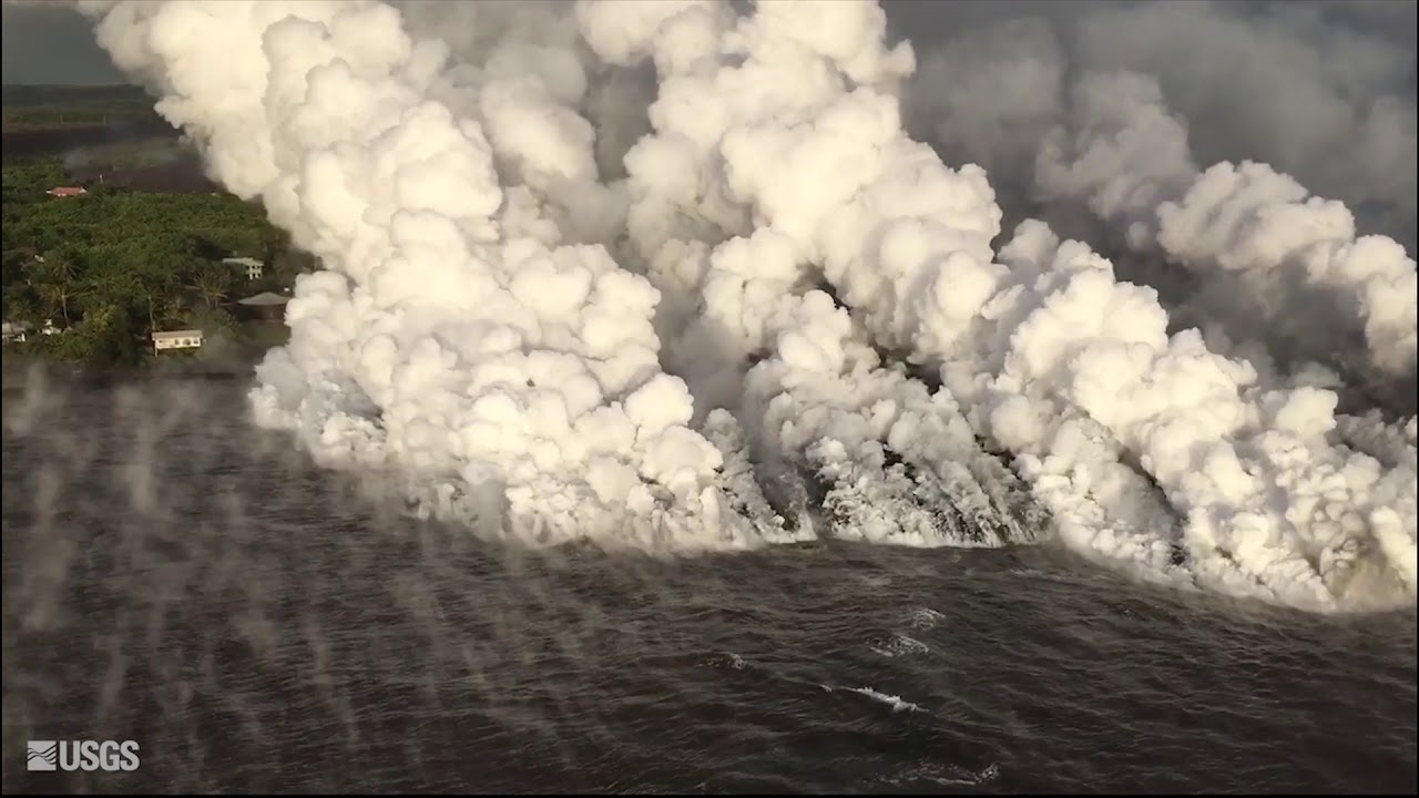
The lava flow from fissure 8 was seen pouring into entering Kapoho Bay during an overflight at 6:13 a.m. Monday. The ocean entry was reported to have occurred by 10:30 p.m. Sunday.

U.S. GEOLOGICAL SURVEY
Lava from fissure 8 filled Kapoho Bay today.

CIVIL AIR PATROL VIA U.S. GEOLOGICAL SURVEY
Lava advanced toward the ocean in the Kapoho area of Hawaii island Sunday afternoon.


UPDATE: 10:40 a.m.
The latest confirmed count of homes overrun by lava has increased to 130 from 117, according to the Hawaii County Civil Defense today.
The figure, however, is expected to soar as “hundreds of homes” are believed to be destroyed in Vacationland and Kapoho Beach Lots, said spokeswoman Janet Snyder.
Lava has ravaged all of Vacationland and only the northern tier of Kapoho Beach Lots remains for now.
>> Scientists expect another explosion, ash plume from Kilauea
>> Kilauea dashes Oahu newlyweds’ dreams
>> Hawaii County Mayor Harry Kim loses home to lava
>> Governor signs proclamation on housing and criminal penalties
>> Lava buries Vacationland, pours into ocean
>> Website to centralize Big Island air quality reporting
>> Kilauea eruption harms up to half of Malama Ki forest reserve
>> Volcanoes National Park’s most important facility damaged by quake
>> Fire helicopter rescues woman, her pet rabbit and chicken isolated by lava
>> 18 arrested in past week for loitering in lava zone
>> Man charged with running Puna checkpoint near approaching lava
RELATED PHOTOS AND VIDEOS
>> Live webcams from Hawaii island
>> Weekend lava activity on Hawaii island in photos, June 4
>> Kilauea lava progression from May 4 to June 5
>> Kilauea update from Hawaiian Volcanic Observatory, June 6
>> Fire helicopter rescues woman, pet rabbit and chicken isolated by lava, June 5
>> Flyover of lava entering Kapoho Bay, June 4
Don't miss out on what's happening!
Stay in touch with top news, as it happens, conveniently in your email inbox. It's FREE!
COMPLETE KILAUEA COVERAGE
>> Star-Advertiser volcano coverage
>> Kilauea Volcano YouTube playlist
Officials are reviewing daily aerial photographs and footage as well as census and property tax records to determine the number of homes consumed by lava.
Census records show about 350 homes at Vacationland and 150 homes at Kapoho Beach Lots, according to Civil Defense Administrator Talmadge Magno.
10 a.m.
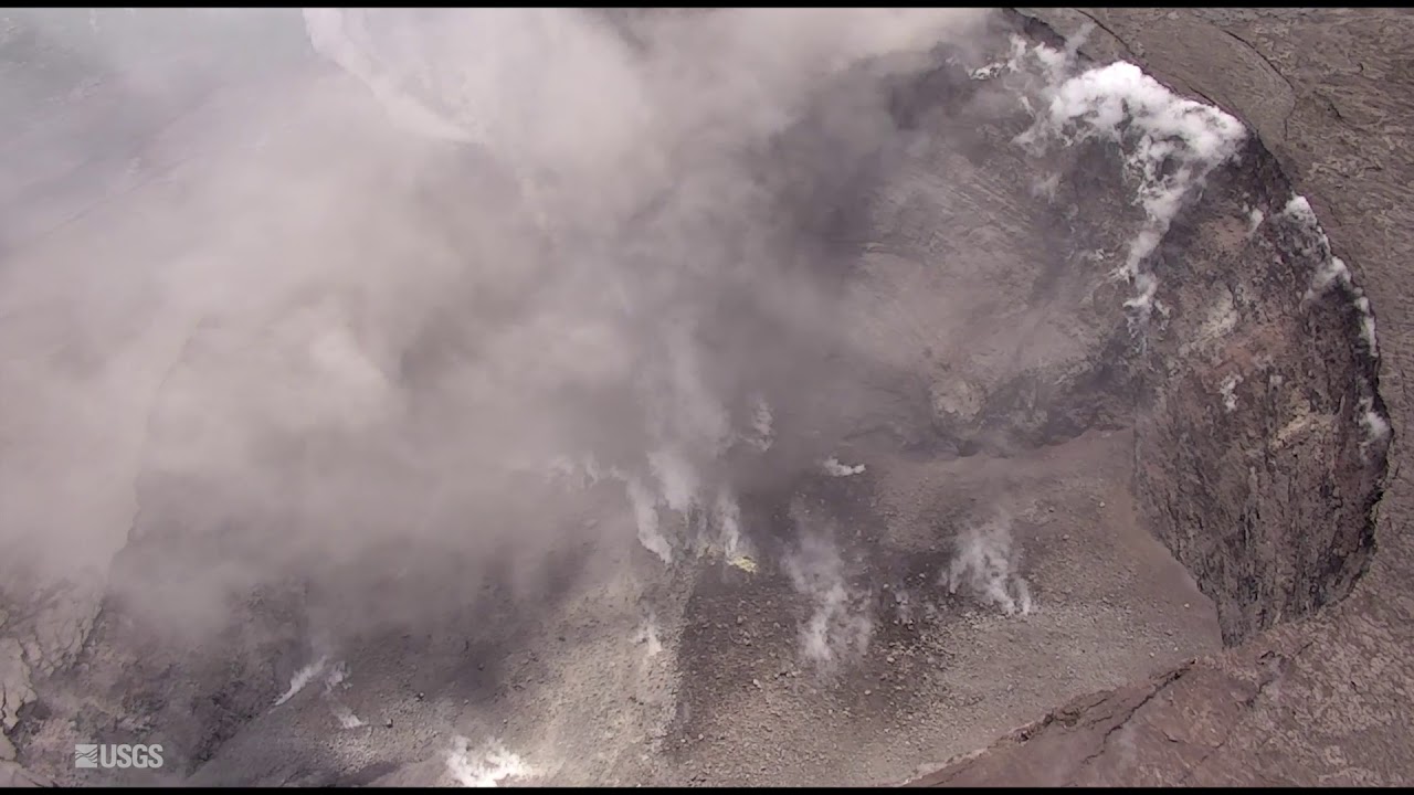
The partial collapse of Halemaumau crater continues as the summit subsides due to the movement of magma toward the East Rift Zone.
7:30 a.m.
The Vacationland subdivision has been completely covered by lava and is entering the ocean in the area.
U.S. Geological Survey officials confirmed the development during a 6:30 a.m. overflight today.
Additionally, lava flows extended 100 yards north in Kapoho Beach Lots as fissure 8 continues fountaining.
5 a.m.
Lava from fissure 8 continued to fountain Tuesday night to heights consistent with those observed earlier in the day.
Hawaiian Volcano Observatory officials said the northernmost lobe of fissure 8 was advancing very slowly to the northeast and that no other fissure vents were active.
June 5 overflight of summit #KilaueaEruption site. #Halemaumau Crater has expanded and collapsed over the past month. Watch the live stream https://t.co/ZfVc8WBpkU & see more videos https://t.co/vOjDzOXaSl #KilaueaSummit #KilaueaEruption pic.twitter.com/xP46wrYAKn
— USGS Volcanoes? (@USGSVolcanoes) June 6, 2018
TUESDAY, JUNE 5
5 p.m.
Lava fountaining at fissure 8 is reported to be at 150 to 180 feet and continues to feed a channel pushing lava to the northeast along Highway 132 and east to the ocean entry in Kapoho Bay area.
Noon
A large laze plume is blowing inland into the air along the coastline near Kapoho Bay, according to Hawaii County Civil Defense.
The Hawaii State Department has partnered with the Civil Defense and the U.S. Environmental Protection Agency to expand air quality stations in the Kilauea East Rift Zone to monitor conditions during volcanic activity. Responders are using data to make evacuation recommendations. The public can access the data here: http://epa.gov/kilaueaairdata.
Fissure 8 continues to produce a large flow that has inundated Vacationland and most of Kapoho Beach Lots. The ocean entry has filled Kapoho Bay and is extending 0.7 miles from shore.
Government Beach Road, between Kahakai Boulevard and Cinder Road, is open to Waa Waa and Papaya Farms Road residents only with official credentials. There is no curfew.
The shelter at Pahoa Community Center is open and pet-friendly. The Keaau Armory shelter has reached capacity.
A community meeting will be held at the Pahoa High School cafeteria at 5 p.m.
9:30 a.m.
Lava has completely filled Kapoho Bay. Hawaiian Volcano Observatory officials confirmed the development during their morning overflight.
The intensity of lava fountaining from fissure 8 declined overnight, with fountain heights fluctuating between 130 and 160 feet, the HVO said. However, the fissure continues to feed a channel transporting lava to the northeast along Highway 132 and east into the ocean at Kapoho Bay.
Lava is also entering the water to the south at the Vacationland tidepools. The northernmost lobe of the fissure 8 flow, around Noni Farms Road, moved 200 yards downslope overnight.
No other fissure vents showed significant activity this morning, the HVO said.
7:15 a.m.
Lava extends 0.7 miles into Kapoho Bay, and most of Vacationland and Kapoho Beach lots have been inundated by lava, Hawaiian Volcano Observatory scientists said after a 6:30 a.m. overflight today.
Fissure 8 is fountaining up to 150 feet high but the lava channel remains full.
7 a.m.
Vigorous lava eruptions continue in the lower East Rift Zone as lava continues to fill in Kapoho Bay.
Fissure 8, which is producing the large channelized flow feeding lava into the bay, is still very active, scientists at the Hawaiian Volcano Observatory said today.
5:15 a.m.
A small explosion occurred at Kilauea’s summit at 4:32 a.m.
A magnitude-5.5 earthquake accompanied the explosion but did not generate a tsunami.
Kilauea expelled an ash plume that rose to around 5,000 feet, according to the National Weather Service.
PREVIOUS COVERAGE
The Hawaiian Volcano Observatory Kapoho Bay has reported lava continued to inundate Kapoho Bay.
As of Monday night, lava was filling Kapoho Bay, extending out roughly 750 yards from shore.
The lava flow pouring into the ocean at Kapoho Bay is emanating a large laze plume along the coastline. Laze is formed when hot lava impacts the ocean, sending hydrochloric acid and steam with fine glass particles into the air.
The corrosive gas mixture causes irritation to eyes, skin and lungs.
Fountaining at fissure 8 remains active with heights reaching up to 130 to 160 feet. The Hawaii Volcano Observatory also reported spattering at fissures 6 and 13, and sluggish lava flows in the proximity of fissure 18.
Field crews are onsite in Kilauea’s lower East Rift Zone tracking the eruption activity.
HVO noted volcanic gas emissions remain very high from the fissure eruptions. Tradewinds are pushing vog to the south and west sides of Hawaii island. Easterly winds forecasted for Tuesday afternoon may bring vog to the Volcano area.
Meanwhile, sulfur dioxide emission rates at the Kilauea summit remain high, impacting air quality in regions downwind.
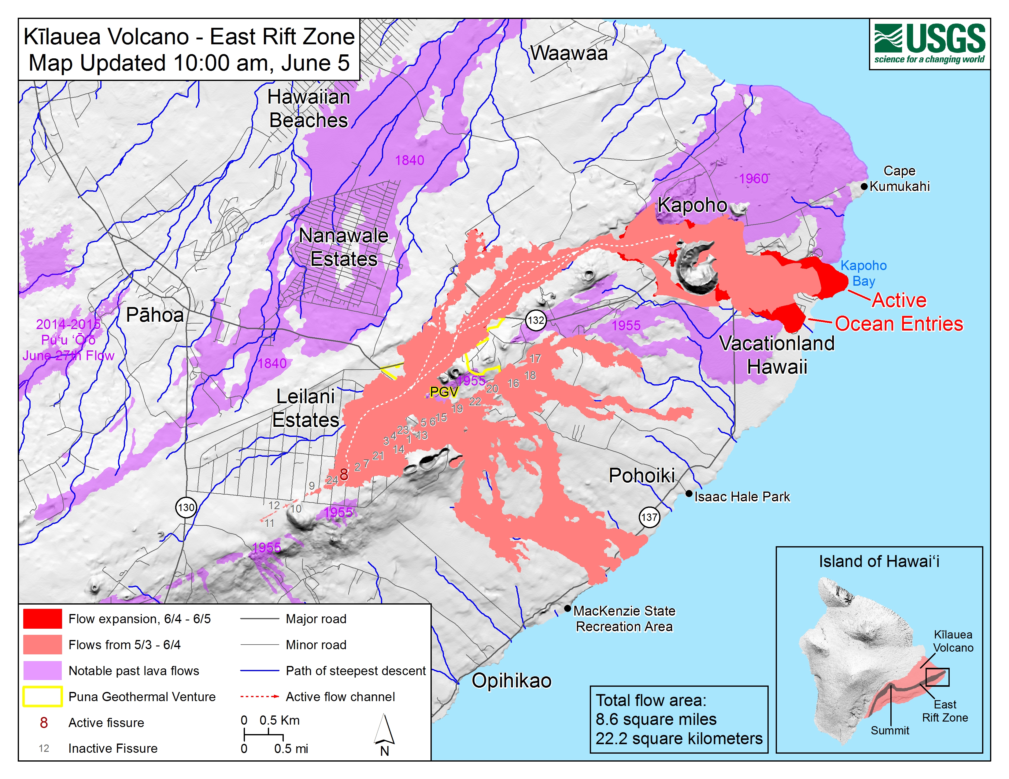
Given the dynamic nature of Kilauea’s lower East Rift Zone eruption, with changing vent locations, fissures starting and stopping, and varying rates of lava effusion, map details shown here are accurate as of the date/time noted. Shaded purple areas indicate lava flows erupted in 1840, 1955, 1960, and 2014-2015. (see large map)


