Tropical Storm Erick passes south of Big Island, as Flossie heads toward Central Pacific
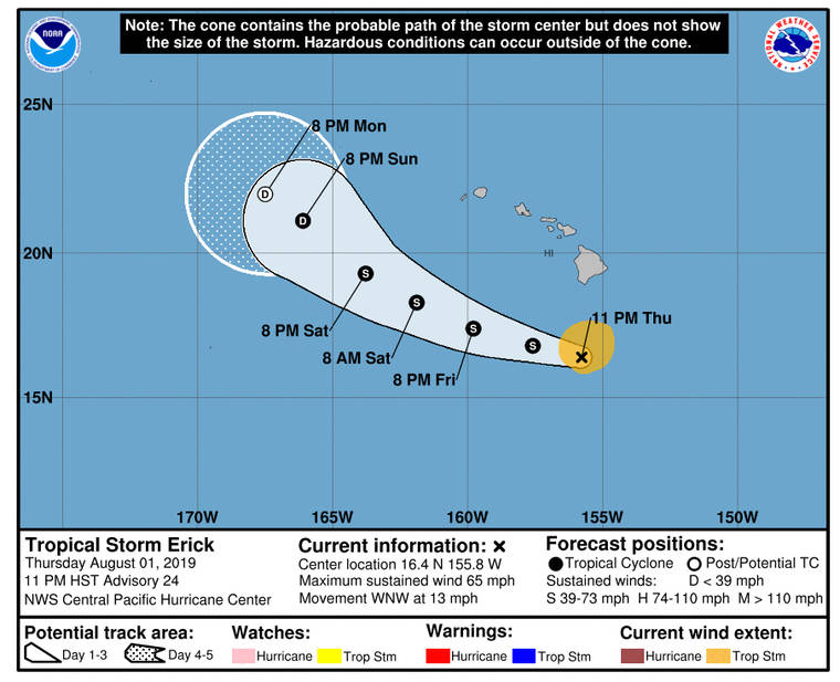
CENTRAL PACIFIC HURRICANE CENTER
Tropical Storm Erick’s five-day forecast as of 11 p.m. Thursday.
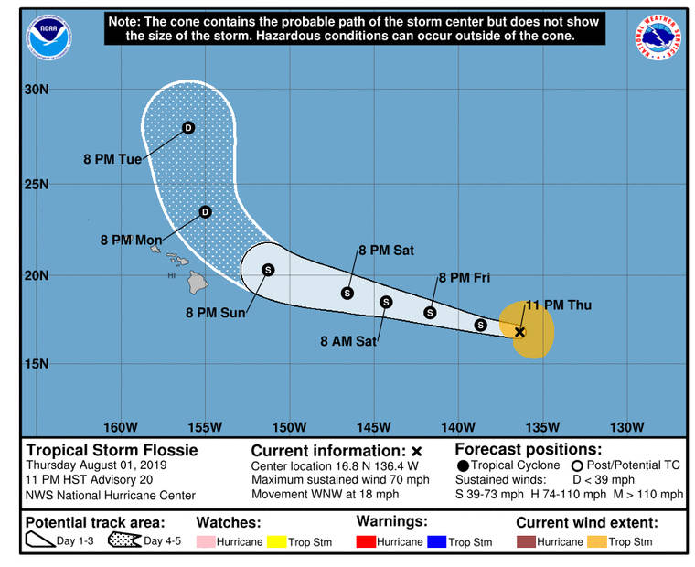
NATIONAL HURRICANE CENTER
Tropical Storm Flossie’s five-day forecast as of 11 p.m. Thursday.


UPDATE: 11 p.m.
Tropical Storm Erick began its pass well south of the state late Thursday, delivering rain to the Big Island and high surf to all islands.
As of 11 p.m., Erick was 230 miles south-southwest of Hilo and 365 miles south-southeast of Honolulu, moving west-northwest at 13 mph with maximum sustained winds of 65 mph.
Erick was expected to pass about 175 miles south of the Big Island overnight, according to the Central Pacific Hurricane Center on Oahu. Tropical storm-force winds extend up to 105 miles from the center.
“Rapid weakening is forecast to continue tonight, followed by gradual weakening Friday into the weekend,” forecasters said. “Erick is expected to become a tropical depression by Sunday, and a post-tropical remnant low on Monday.”
Despite the relative near-miss for the islands, the National Weather Service expects potential rainfall amounts of 4 to 8 inches for parts of the islands.
Don't miss out on what's happening!
Stay in touch with breaking news, as it happens, conveniently in your email inbox. It's FREE!
Forecasters have issued a host of warnings and advisories as the storm passes, including:
>> A flash flood watch for the Big Island through Saturday morning.
>> A high surf warning for the Big Island with waves up to 15 to 20 feet, decreasing to 10 to 15 feet through Friday.
>> A high surf advisory with waves from 6 to 10 feet and locally higher sets along eastern shores of Kauai, Oahu and Maui, and the southern shores of Kauai and Oahu until 6 p.m. Friday.
>> A wind advisory for Hawaii island and Maui with east winds of 20 to 40 mph and gusts over 45 mph through Friday. “Winds this strong are capable of downing trees and causing power outages,” forecasters said.
>> A small craft advisory for Hawaii waters with east winds 20 to 30 knots and seas 8 to 13 feet.
As Erick passes to the south, Tropical Storm Flossie approaches from the East Pacific on a path that is expected to take it just north of the islands early next week.
As of 11 p.m. Thursday, Flossie was 1,240 miles east of Hilo with maximum sustained winds of 70 mph, moving west-northwest at 18 mph. Tropical storm-force winds extend up to 140 miles from the center, according to the National Hurricane Center in Miami.
Flossie was expected to cross into the Central Pacific Friday afternoon. Its five-day forecast has it passing north of the islands as a weak tropical storm or a tropical depression Monday and Tuesday.
Like Erick, Flossie could also bring heavy rain and high surf to the islands, forecasters warn.
5 p.m.
Hurricane Erick has downgraded to a tropical storm and is expected to weaken to a tropical depression by Sunday, the National Weather Service said today.
Erick, located about 265 miles south of Hilo and 435 miles south-southeast of Honolulu, is moving toward the west-northwest near 13 mph.
On the forecast track, Erick will pass within about 200 miles south of the Big Island tonight.
Maximum sustained winds are near 70 mph with higher gusts and tropical-storm-force winds extend outward up to 105 miles from the center. Winds will remain gusty through Saturday as Erick passes, however, significant weakening is forecast during the next couple of days.
“Deep tropical moisture expected to move over the islands north of Erick will translate to increasing rainfall chances, initially over the eastern portion of the state tonight, then across the smaller islands Saturday,” weather officials said. “The best chance for heavy rainfall and flash flooding will remain over Big Island windward areas.”
Additional impacts will include high surf for the exposed coasts.
Tropical Storm Flossie is forecast to bring additional impacts to the islands as it approaches later this weekend through early next week.
On the forecast track, Flossie should cross into the central Pacific basin Friday afternoon, weather officials said today.
Flossie, located about 1,350 miles east of Hilo, is moving toward the west-northwest near 18 mph.
Maximum sustained winds have increased to near 70 mph with higher gusts. The National Weather Service said Flossie has the potential to become a hurricane overnight before a gradual weakening begins by late Friday. Tropical-storm-force winds extend outward up to 115 miles from the center.
With the storms losing some steam, the planned deployment to Hawaii of three Air Force Reserve “hurricane hunter” WC-130J aircraft was canceled, officials said.
The three aircraft and a C-130J Super Hercules with extra cargo for the mission took off Monday from Mississippi to provide weather support for Erick and Flossie, the Air Force had reported.
Three weather crews assigned to the 53rd Weather Reconnaissance Squadron were expected to start flying missions Wednesday.
But the Air Force’s 15th Wing at Joint Base Pearl Harbor-Hickam said in an email Wednesday that “the hurricane hunters did not make it out to Hawaii as the National Hurricane Center canceled the tasking.”
11 a.m.
Hurricane Erick strengthened slightly this morning as it approached Hawaii island. However, Tropical Storm Flossie continued to lose strength.
Erick remains a Category 1 hurricane, with maximum sustained winds of 80 mph at 11 a.m. and centered about 285 miles south-southeast of Hilo and 480 miles southeast of Honolulu, according to the Central Pacific Hurricane Center. It’s moving west-northwest near 14 mph.
Significant weakening is forecast during the next couple of days, and Erick is expected to weaken to a tropical storm later today or tonight, the CPHC said.
Erick’s current heading is expected to continue over the next couple of days while Erick passes within about 200 miles south of Hawaii island later today and tonight, the CPHC said.
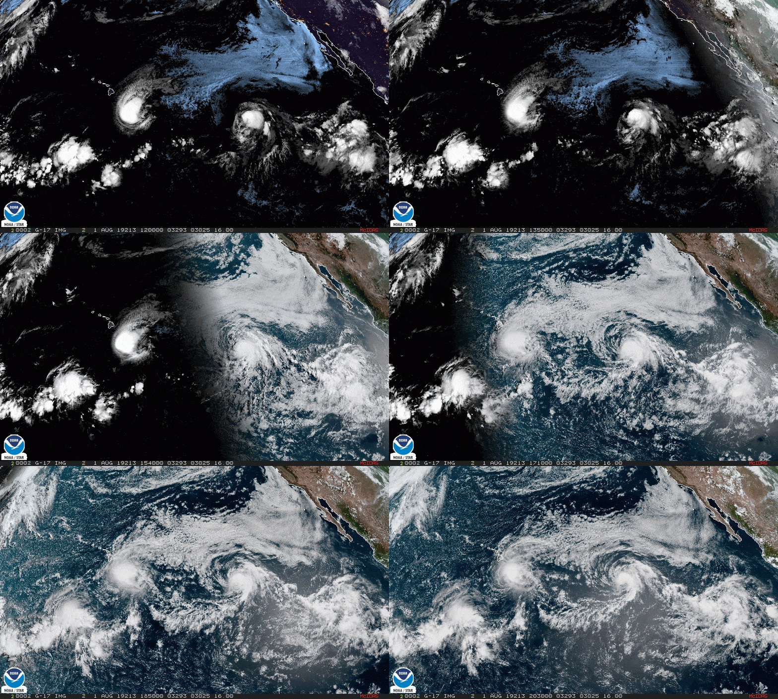
Hurricane-force winds extend outward up to 25 miles from Erick’s center and tropical-storm-force winds extend outward up to 105 miles.
Meanwhile, Tropical Storm Flossie continued to weaken in the Eastern Pacific. Centered about 1,460 miles east of Hilo, Flossie packed maximum sustained winds of 65 mph at 11 a.m. and was moving west-northwest at 18 mph, the National Hurricane Center said.
Gradual weakening is expected during the next two to three days, the NHC said.
Additionally, Flossie is expected to decrease in forward speed through early Sunday and cross into the central Pacific basin late Friday or early Saturday.
Tropical-storm-force winds extend outward up to 125 miles from Flossie’s center.
PREVIOUS COVERAGE
Although it’s expected to weaken to a tropical storm today, Erick was still hanging on as a hurricane this morning as Tropical Storm Flossie held steady further east.
Hawaii island started feeling some of the effects of Erick Wednesday with high surf pounding its east-facing shores. A high-surf warning remains in effect through 6 p.m. today with surf of up 15 to 20 feet expected.
Centered about 315 miles southeast of Hilo and 520 miles southeast of Honolulu at 5 a.m., Hurricane Erick is packing maximum sustained winds of 85 mph while moving west-northwest at 15 mph, according to the Central Pacific Hurricane Center.
Significant weakening is forecast during the next couple of days and Erick is expected to weaken to a tropical storm later today, the CPHC said.
Forecast to continue on its current heading for the next couple of days, Erick is expected to pass within about 200 miles south of Hawaii island later today and tonight, the CPHC said.
Hurricane-force winds extend outward up to 25 miles from Erick’s center and tropical-storm-force winds extend outward up to 105 miles.
Meanwhile, Tropical Storm Flossie was centered 1,580 east of Hilo at 5 a.m. while packing maximum sustained winds of 65 mph and moving west-northwest at 16 mph, the CPHC said.
Although weather officials don’t expect Flossie to change much in strength over the next few days, it’s forecast to slowly begin weakening on Saturday.
It’s expected to continue on its current heading through early Sunday, crossing into the Central Pacific late Friday or early Saturday.
Tropical-storm-force winds extend outward up to 125 miles from Flossie’s center.
A wind advisory is scheduled to go into effect for Maui County and Hawaii island from noon today through 6 p.m. Friday.
Forecasters anticipate easterly winds of 25 to 35 mph with gusts of 45 mph this afternoon through Friday as Tropical Cyclone Erick passes to the south of the islands.


