Explosive device closes Mauna Loa viewing area

COURTESY USGS
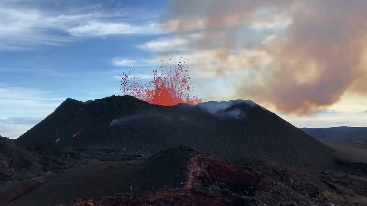
An aerial view of Fissure No. 3 on the northeast rift zone of Mauna Loa this morning.
The Hawaii County Police Department reopened the parking area on old Saddle Road on Sunday afternoon following the conclusion of a police investigation that closed the Mauna Loa eruption viewing area for nearly five hours.
“The closure was due to an explosive device that was located and has since been neutralized,” police said in an email.
No communities were at risk during this time, officials said in a statement.
The eruption has reached its seventh day as the lava flow creeps closer north toward Daniel K. Inouye Highway, which remains open to traffic in both directions.
The Hawaiian Volcano Observatory reported Fissure 3 as the only active flow with “minimal movement” and that it remained near the 7,000-foot elevation.
As of noon Sunday, U.S. Geological Survey officials reported the front of the flow was about 2.25 miles from the key highway. Over the previous 24 hours, the flow moved at an average rate of about 40 feet per hour with the rate of movement slowing over the past several days. USGS officials said the rate of advance may be “highly variable over the coming days and weeks” depending on the terrain.
Don't miss out on what's happening!
Stay in touch with top news, as it happens, conveniently in your email inbox. It's FREE!
USGS officials reported the lava flows are thickening and spreading out as they move over the low-sloping ground. “The fronts of lava flows can break open unexpectedly, sending flows in several directions. Rain on lava creates steam and reduces visibility,” according to a statement. Officials said it was difficult to estimate when or whether the flow will affect the highway.
For onlookers wanting to get a glimpse of the eruption, expect and plan for delays between the 28- and 34-mile markers due to vehicle congestion.
USGS officials are urging people to stay in their vehicles to view the eruption and avoid approaching the flows.
Hawaii County Mayor Mitch Roth on Friday announced the opening of a viewing area on old Saddle Road to relieve traffic congestion along Daniel K. Inouye Highway. Roth estimated 2,000 cars used the area to park Thursday night, allowing spectators to watch the eruption from a safe distance. The speed limit has been reduced to 35 mph near Mauna Kea Access Road and Gilbert Kahele Park.
The observatory has reduced the aviation color code to orange from red. The Federal Administration Aviation has issued a temporary flight restriction in the eruption area from the surface to 1,500 feet above ground level.


