Tropical Storm Ophelia gathers strength off mid-Atlantic coast

NOAA VIA ASSOCIATED PRESS
This Thursday, Sept. 21, 2023, satellite image provided by the National Oceanic and Atmospheric Administration shows a potential tropical cyclone forming off the southeastern coast of the United States in the Atlantic Ocean.

KENDALL WARNER/THE VIRGINIAN-PILOT VIA ASSOCIATED PRESS
Waves break along the jetty at Rudee Inlet in Virginia Beach, Va., today, as Tropical Storm Ophelia approaches the area. Tropical Storm Ophelia was gaining strength as it churned toward the North Carolina coast today, promising a weekend of heavy rain and windy conditions throughout the mid-Atlantic.
ANNAPOLIS, Md. >> Tropical Storm Ophelia gained strength as it churned toward the North Carolina coast on Friday, promising a weekend of heavy rain and windy conditions throughout the mid-Atlantic.
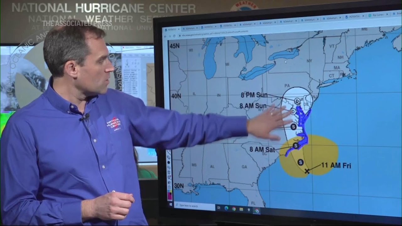
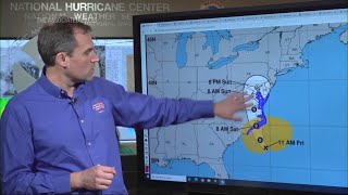
Forecasters issued a hurricane watch for parts of eastern North Carolina. The storm was expected to make landfall in North Carolina on Saturday morning and dump as much as 7 inches (17.7 centimeters) of rain across portions of the state and into southeast Virginia.
The intensifying weather system spun into a tropical storm in the afternoon and by nighttime was producing maximum sustained winds of 70 mph (113 kph), with higher gusts, according to the U.S. National Hurricane Center.
The storm was not expected to gain further strength before landfall and was forecast to weaken afterward, according to the hurricane center.
Just before 11 p.m., forecasters said Ophelia was about 70 miles (115 kilometers) south of Cape Lookout, North Carolina, and heading north-northwest at 12 mph (19 kph).
Water levels were rising along portions of the North Carolina coast, and a storm surge warning was in effect for some areas. Surges between 3 and 5 feet (0.9 and 1.5 meters) were forecast for parts of the state, the hurricane center said.
Don't miss out on what's happening!
Stay in touch with top news, as it happens, conveniently in your email inbox. It's FREE!
The governors of North Carolina, Virginia and Maryland declared a state of emergency. Some schools closed early as communities prepared for the storm’s arrival, and several weekend events were canceled.
“We are expecting an extended period of strong winds, heavy rainfall, and elevated tides,” Maryland Gov. Wes Moore said in an evening statement.
Nancy Shoemaker and her husband Bob stopped by a waterside park in downtown Annapolis, Maryland’s capital, to pick up sandbags to help protect their waterfront home.
Last October, they experienced a big surge of water that came into their yard and even washed some sandbags away.
“We’re hoping it won’t be that way this time,” Nancy Shoemaker said. “If we have a lot of wind and a lot of surge, it can look like the ocean out there, so that’s a problem.”
A storm surge warning was in effect from Beaufort Inlet, North Carolina, to Chincoteague, Virginia, and a tropical storm warning was issued from Cape Fear, North Carolina, to Fenwick Island, Delaware.
Ophelia affected water taxis Friday in Annapolis, where driver Scott Bierman said service would end at 6 p.m. and close Saturday.
“We don’t operate when it’s going to endanger passengers and or damage vessels,” Bierman said.
In Washington, the Nationals baseball team postponed its Saturday game until Sunday.
It’s not uncommon for one or two tropical storms — or even hurricanes — to form right off the East Coast each year, said Michael Brennan, director of the National Hurricane Center.
“We’re right at the peak of hurricane season, we can basically have storms form anywhere across much of the Atlantic basin,” Brennan said.
Scientists say climate change could result in hurricanes expanding their reach into mid-latitude regions more often, making storms like this month’s Hurricane Lee more common. One study simulated tropical cyclone tracks from pre-industrial times, modern times and a future with higher emissions. It found that hurricanes would track closer to the coasts including around Boston, New York and Virginia and be more likely to form along the Southeast coast.
North Carolina Gov. Roy Cooper issued his state’s emergency declaration aiming to expedite preparations and help provide a swift response.
“The storm’s path has been difficult to predict and we want to ensure that farmers, first responders and utility crews have the tools necessary to prepare for severe weather,” Cooper said.
The North Carolina Ferry System suspended service on all routes on Friday until conditions improve, officials said.
Virginia Gov. Glenn Youngkin’s executive order also sought to ease response and recovery efforts.
“We want to ensure that all communities, particularly those with the greatest anticipated impact, have the resources they need to respond and recover from the effects of this storm,” Youngkin said.
The governor encouraged residents to prepare an emergency kit and follow the weather forecast closely.
Meanwhile, Hurricane Nigel was downgraded to a post-tropical cyclone centered about 640 miles (1,030 kilometers) northwest of the Azores, with maximum sustained winds of 70 mph (110 kph). There were no associated coastal watches or warnings as the storm moved northeast at 37 mph (59 kph), the hurricane center said in its final update on the system Friday morning.


