Hurricane Ignacio gains strength as it nears islands
At 11 p.m. Saturday, Ignacio was 495 miles east-southeast of Hilo and 705 miles east-southeast of Honolulu.
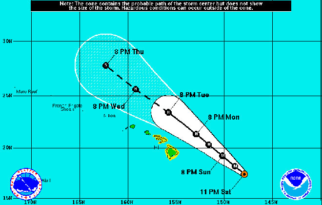
Hurricane Kilo, far from the main Hawaiian islands, is expected to remain at major hurricane strength this week.
This enhanced satellite image shows Hurricane Ignacio as it heads northwest toward Hawaii Saturday.
At 11 p.m. Saturday, Jimena was about 1,365 miles west-southwest of the southern tip of Baja California.
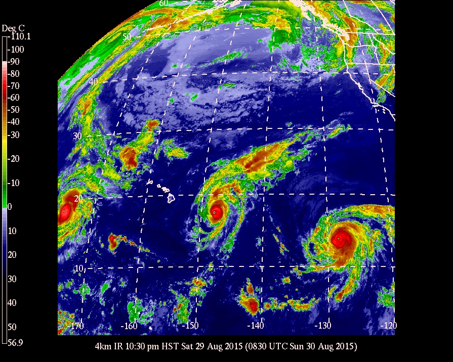
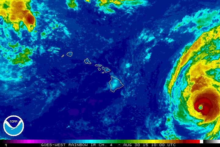
This enhanced satellite image shows three major hurricanes in the northern Pacific late Saturday. Hurricane Kilo, far left, was moving further away from the main Hawaiian islands, as Hurricane Ignacio approached the state from the east and Hurricane Jimena continued on a track toward the Central Pacific.
A tropical storm watch for Maui and Hawaii counties is in effect as Ignacio, now a Category 4 hurricane, approaches the state, forecasters at the Central Pacific Hurricane Center said.
At 5 a.m. Sunday, Ignacio was 450 miles east-southeast of Hilo and 650 miles east-southeast of Honolulu with maximum sustained winds of 140 mph, making it a major hurricane. It was moving northwest at 8 mph.
Hurricane-force winds extend 30 miles from the center and tropical storm-force winds extend 140 miles.
The hurricane center has also issued a tropical storm warning for the windward and southeast waters of Hawaii island. The warning replaces a previously issued tropical storm watch for Hawaii County waters. A tropical storm watch is in effect for the Alenuihaha Channel, which separates Hawaii island and Maui.
The hurricane center on Oahu says other islands may be added to the tropical storm watch Sunday. A watch means that tropical storm conditions are possible in the next 48 hours.
The Big Island is also under a high surf warning through 6 p.m. Tuesday, with waves increasing to 15 to 20 feet late Sunday on east shores.
Don't miss out on what's happening!
Stay in touch with breaking news, as it happens, conveniently in your email inbox. It's FREE!
"Expect ocean water surging and sweeping across beaches, coastal benches, and lava flows creating the potential for impacts to coastal properties and infrastructure, including roadways," the National Weather Service said.
"These dangerous conditions mean that only highly experienced persons should enter the water. Inexperienced persons should remain off beaches and adjacent beachfront areas. Large breaking surf, significant shore break and dangerous currents make entering the water very hazardous. Anyone entering the water could face significant injury or death," the weather service said.
Ignacio has likely reached peak intensity and is expected to weaken through Monday.
The five-day forecast track for Ignacio has the storm passing north of the islands this week as it gradually weakens. However, forecasters and government officials warn that there is still uncertainty about the storm’s path so residents need to be prepared.
"If Ignacio shifts to the right, we could see light winds, more humid conditions, and localized heavy rain. On a more leftward track closer to the islands, we could see stronger/damaging winds and more widespread heavy rain/flooding. Everyone should continue to monitor the progress of Ignacio during the next several days," weather service forecasters said.
Forecasters said total rainfall amounts of 2 to 5 inches, with isolated amounts near 6 inches mainly in areas of higher terrain, are possible.
Maui Mayor Alan Arakawa signed an emergency proclamation Saturday in anticipation of Ignacio.
"I urge all citizens to prepare their homes, family members and pets for the potential impacts of Ignacio,” said Arakawa. “Now is the time to stock up on seven days of water and non-perishable food supplies, and to secure or move inside any loose objects around your home that could become airborne missiles. Make sure you have on-hand fresh batteries for your radios and flashlights, and keep your vehicles fully fueled.”
Gov. David Ige also signed an emergency proclamation on Friday. The proclamation activates the major disaster fund set aside by the Legislature for disaster relief, provides easier access to emergency resources at the state and federal levels, and allows the suspension of certain laws for emergency purposes, according to Ige’s office.
Ignacio is one of three major hurricanes in the northern Pacific.
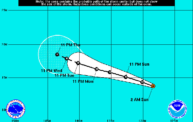
Further east but headed toward the Central Pacific is Category 4 Hurricane Jimena with maximum sustained winds of 130 mph. Fluctuations in intensity are possible during the next day or so, but Jimena is expected to remain a major hurricane through Monday, the National Hurricane Center said.
At 11 p.m. Saturday, Jimena was about 1,365 miles west-southwest of the southern tip of Baja California, moving west-northwest at 13 mph.
Hurricane-force winds extend outward up to 35 miles from the center and tropical storm-force winds extend up to 125 miles, according to forecasters with the National Hurricane Center in Miami.
As with Ignacio, however, forecasters warn that there is still much uncertainty with Jimena’s eventual path, so Hawaii residents need to remain vigilant and monitor media reports for both storms.
Officials have expressed concern that this busier-than-normal, El Nino-fueled hurricane season may lead to storm "fatigue" among residents who have watched several tropical cyclones threaten the islands in the past month. Officials stress that having a hurricane kit and plan is essential for all residents.
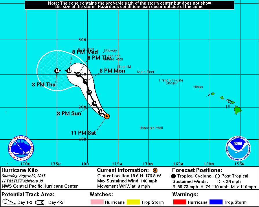
Kilo, the last storm to menace Hawaii, intensified rapidly this weekend into a major category 4 hurricane far to the west of the main islands.
At 11 p.m. Saturday, Kilo was 665 miles south of Midway Island with maximum sustained winds of 140 mph and moving west-northwest, away from the main Hawaiian islands, at 9 mph.


