Norman forecast to approach the Central Pacific basin Tuesday

NATIONAL HURRICANE CENTER
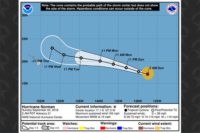
Hurricane Norman’s forecast track as of 11 p.m. HST Saturday.
UPDATE: 11 p.m.
Norman is forecast to slow down by midweek after crossing into the Central Pacific on Tuesday.
Forecasters said it’s expected to move west-northwestward for the next couple of days.
Norman is currently moving in this direction near 15 mph, with no significant change in intensity ahead.
At last check, Norman was located about 1,820 miles east of Hilo and about 2,000 miles east-southeast of Honolulu.
Maximum sustained winds are near 105 mph with higher gusts. Hurricane-force winds extend outward up to 35 miles from the center and tropical-storm-force winds extend outward up to 115 miles.
Don't miss out on what's happening!
Stay in touch with breaking news, as it happens, conveniently in your email inbox. It's FREE!
5 p.m.
Hurricane Norman continues to move west as a Category 2 hurricane.
Norman is expected to enter the Central Pacific basin on Tuesday.
Norman, with winds near 105 mph, is located 1,661 miles east of Hilo. Norman is moving toward the west near 13 mph. A west-northwestward motion with a slight increase in forward speed is expected through early next week.
Gradual weakening is expected to begin Sunday night through early next week.
Meanwhile, Tropical Depression Seventeen-E is forecast to strengthen off the Mexican coast. With winds near 35 mph, it is located 545 miles south-southwest of Baja California and 560 miles west-southwest of Manzanillo, Mexico.
11 a.m.
Norman is holding steady as a Category 2 hurricane.
Hurricane Norman is expected to approach the Central Pacific basin Tuesday and gradually start weakening Sunday.
Norman was packing maximum sustained winds near 105 mph with higher gusts. Norman was located about 1,982 miles east-southeast of Hilo and 2,166 miles east-southeast of Honolulu.
“A general westward to west-northwestward motion with an slight increase in forward speed is expected through early next week,” the forecast said.
Hurricane-force winds extend outward up to 25 miles from the eye of the storm and tropical-storm-force winds extend outward up to 105 miles.
8 a.m.
Still a Category 2 hurricane, Hurricane Norman appeared to have weakened a little this morning.
Forecasters are predicting Norman to cross the Central Pacific basin early next week, according to the National Weather Service National Hurricane Center.
Norman was last located 2,074 miles east-southeast of Hilo and 2,258 miles east-southeast of Honolulu. Norman was packing maximum sustained winds of near 105 mph with higher gusts.
“A general westward to west-northwestward motion with an slight increase in forward speed is expected through early next week,” the forecast said.
Hurricane-force winds extend outward up to 25 miles from the eye of the storm and tropical-storm-force winds extend outward up to 105 miles.
FRIDAY, AUG. 31
11 p.m.
Norman has downgraded to a category 2 hurricane moving toward the west near 8 mph.
It was last located about 2,115 miles east-southeast of Hilo and about 2,300 miles east-southeast of Honolulu.
Forecasters said a general westward to west-northwestward motion is expected through early next week. Norman is forecast to approach the Central Pacific on Tuesday.
Maximum sustained winds have decreased to near 110 mph with higher gusts. Hurricane-force winds extend outward up to 30 miles from the center, and tropical-storm-force winds extend outward up to 105 miles.
5 p.m.
Hurricane Norman continues to slowly weaken but remains a Category 3 hurricane.
Norman is located 1,880 miles east of Hilo with winds near 120 mph. It is moving toward the west-southwest near 8 mph. A turn toward the west and west-northwest with an increase in forward speed is expected over the weekend and into next week.
Meanwhile, Tropical Depression Seventeen-E has formed in the Eastern Pacific off the Mexican coast. It is located 2,686 miles east of Hilo with winds near 35 mph. The depression is moving toward the west-northwest near 10 mph.
11 a.m.
Norman continued to weaken in the Eastern Pacific and is now a Category 3 hurricane.
Located about 2,212 miles east of Hilo, Norman was clocked with 125 maximum sustained winds headed west-southwest at 8 mph, according to the National Hurricane Center.
A turn toward the west and west-northwest with an increase in forward speed is expected over the weekend and into next week.
Gradual weakening is forecast, but Norman is expected to remain a powerful hurricane through the early part of next week.
Hurricane-force winds extend outward up to 35 miles from Norman’s center and tropical-storm-force winds extend outward up to 105 miles.
PREVIOUS COVERAGE
Although Norman remains a Category 4 hurricane, it’s continuing to weaken today.
Located about 2,255 miles east of Hilo, Norman was packing maximum sustained winds of 130 mph and heading west-southwest at 8 mph at 5 a.m. today, according to the National Hurricane Center.
A turn toward the west and west-northwest with an increase in forward speed is expected over the weekend and into next week.
Gradual weakening is also forecast, but Norman is expected to remain a powerful hurricane through the early part of next week.
Hurricane-force winds extend outward up to 25 miles from Norman’s center and tropical-storm-force winds extend outward up to 90 miles.
Although it was still a hurricane this morning, Miriam Opens in a new tab is forecast to rapidly weaken to a post-tropical remnant low Sunday or Sunday night.


