LIVE BLOG: Mauna Loa traffic prompts new viewing route


ASSOCIATED PRESS / NOV. 30
A man talks on a phone in his car alongside Saddle Road as the Mauna Loa volcano erupts near Hilo. Hundreds of people in their cars lined Saddle Road, which connects the east and west sides of the island, as lava flowed down the side of Mauna Loa and could be seen fountaining into the air on Wednesday.

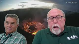
COURTESY USGS
A screenshot of the eruption at Fissure No. 3, at 8:42 a.m. today, on the Northeast Rift Zone of Mauna Loa volcano.

ASSOCIATED PRESS
A journalist, left, records lava from the Mauna Loa volcano as it erupts, Wednesday, near Hilo.

COURTESY USGS
A screenshot of the eruption at Fissure No. 3 this morning on the Northeast Rift Zone of Mauna Loa volcano.

COURTESY USGS
The Mauna Loa lava advance slows to a rate of 0.02 mph, Wednesday.
Editor’s Note: Bookmark this page! This story is developing and will be updated as soon as more information becomes available.
____
UPDATE: 4:41 p.m.
According to the Hawaiian Volcano Observatory, lava continues to flow in the northeast rift zone of Mauna Loa volcano.
Daniel K. Inouye Highway, which is still open in both directions, is more than three miles away from the lava flow.
Hawaii County Civil Defense Agency said the leading edge of the flow closest to the highway had “minimal movement,” which was described as near the 7,000-foot elevation.
Don't miss out on what's happening!
Stay in touch with top news, as it happens, conveniently in your email inbox. It's FREE!
The agency reminds the public that a traffic hazard mitigation route will provide a safer area to view the eruption.
12:30 p.m.
Hawaii County Mayor Mitch Roth today announced a new “traffic hazard mitigation route” to address safety concerns due to increased traffic of onlookers along the Daniel K. Inouye Highway.
Thousands of visitors have created traffic jams with their vehicles on Saddle Road, which connects Hilo on the east side of Hawaii Island and Kailua-Kona on the west side, attempting to get a closer look at the Mauna Loa eruption.
Officials said the one-way route uses the old Saddle Road with the entrance located directly across from the Gilbert Kahele Recreation Area. The route is 4.5 miles from the entryway to a junction point located just before Puu Huluhulu, which is located across from the highway’s intersection with Mauna Kea Access Road. See the map below.

A map of the new traffic route to help mitigate traffic concerns due to the Mauna Loa eruption. Click here to view the map.
Passenger vehicles are allowed, but commercial vehicles are prohibited from entering. Signs and barricades will be present. Safety officers will be on the scene to help direct traffic flow.
Parking will only be allowed on the right side, but vehicles cannot stay in the area for more than 90 minutes, officials said.
>> RELATED: Prayers? Bombs? Hawaii history shows stopping lava not easy
“We are humbled to have come together with our state and federal partners to find a potential solution to the ongoing safety concerns along Saddle Road,” said Roth in a statement. “Our teams have worked tirelessly to keep the community safe through this eruption, and through the creation of the traffic hazard mitigation route, we believe that there will be significantly less risk to our community.”
Motorists are asked to drive with extreme caution given the roadway will be busy during the eruption.
The Gilbert Kahele Recreational Area, including both the lower and upper bathrooms, will be open 24 hours each day until further notice, officials said. Security guards will be onsite nightly from 6:15 p.m. to 6:15 a.m.
10:15 a.m.
The leading edge of the Mauna Loa lava flow has slowed to the point that it won’t reach the Daniel K. Inouye Highway for at least a week, according to Ken Hon of the Hawaiian Volcano Observatory.
That doesn’t mean lava production has lessened. Rather, it’s a reflection of the flat terrain, the scientist-in-charge said in this morning’s news briefing.
The flow has traveled a couple tenths of a mile closer to the highway but it was still 3.3 miles south of the busy road, moving at a rate of 30 to 40 yards per hour.
Hon said he would expect the flow’s movement to become sporadic as it works its way across the flat ground.
“It will inflate. Incoming lava will be stored in it, and then it will probably come out in lobes at different times. At some times it will appear to be moving faster and other times it will not be moving at all,” he said.
The flow, he said, is right on the divide between lava either going to the east side of the island or the west side.
“We don’t really know which way the lava flow will ultimately go,” he said. “There’s a lot of uncertainty here.”
The wind has shifted so that volcanic emissions are now blowing to the south. Hon said that there have been reports of Pele’s hair blown 15 miles downwind.
8:45 a.m.
The leading edge of the flow closest to Daniel K. Inouye Highway has had “minimal movement” and remains near the 7,000-foot elevation and more than 3 miles from the highway, according to Hawaii County Civil Defense.
Motorists who park along Daniel K. Inouye Highway between the 16 mile marker and the junction with Highway 190 will be subject to a traffic citation and vehicle towing, the Hawaii County Police Department said.
7 a.m.
Lava flows today are continuing down the northeast slope of Mauna Loa.
The flow front has hit a low-sloping spot and is beginning to spread out and inflate, the U.S. Geological Survey said.
PREVIOUS COVERAGE
Mauna Loa’s first eruption in 38 years entered its fourth day today with several fissures active and lava flows moving in north and northeast directions.
The Fissure No. 3 lava flows are traveling north toward Daniel K. Inouye Highway and were about 3.6 miles from the critical transportation route as of Wednesday afternoon, according to the Hawaiian Volcano Observatory.
>> RELATED: Lava slows on Mauna Loa, but busy highway vulnerable
The flows are beginning to slow and spread out as they reach the relatively flat saddle region.
The largest lava flow, fed dominantly by Fissure No. 3, slowed to a rate of 0.02 miles per hour between 7 a.m. and 12:30 p.m. Wednesday, the U.S. Geological Survey said in a report.
Fissure No. 4 is still active with lava flows moving northeast. A small lobe is moving east at a slower rate than the main lobe, the USGS said Wednesday.
Seismic monitoring of the site has detected tremors, or a high rate of earthquakes, in the vicinity of the active fissures, indicating that magma is still being supplied.
No active lava has been seen in Moku’āweoweo caldera and the Southwest Rift Zone is not erupting. The USGS does not expect eruptive activity outside of the Northeast Rift Zone.
With authorities issuing $1,000 parking tickets to volcano watchers along Daniel K. Inouye Highway, officials are working to open up a new public viewing area at the Pohakuloa Training Area.
The public may park at the Gilbert Kahele Recreational Area which will remain open 24 hours a day until further notice. Security guards will be on site from 6:15 p.m. to 6:15 a.m. daily.
Hawaii County and HVO continue to caution that eruptions from Mauna Loa, the world’s largest volcano, can be unpredictable and long-lasting, and they recommend residents visit the county’s volcano hazards website for more information and updates.


