Explosions produce ash cloud that rose to 11,000 feet


HAWAIIAN VOLCANO OBSERVATORY
The view this morning from the HVO observation tower of the Halemaumau Overlook Vent.

COURTESY HAWAII COUNTY FIRE DEPARTMENT
Eruption activity continues in the Lower East Rift. Volcanic gas emissions are elevated from the fissure eruptions.

GEORGE F. LEE / GLEE@STARADVERTISER.COM
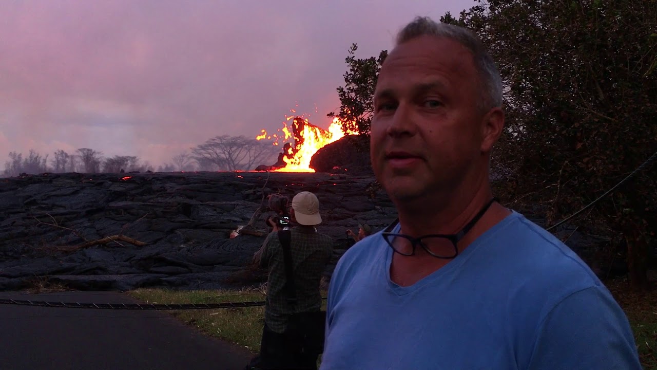
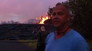
Area residents watched and recorded video as Kilauea volcano continued her fiery show, throwing lava several stories into the air and building cinder cones in Leilani Estates Wednesday evening.

GEORGE F. LEE / GLEE@STARADVERTISER.COM
Kilauea volcano shot lava several stories into the air and building cinder cones in Leilani Estates at what is now the end of Kahukai Street, on Wednesday evening.

COURTESY USGS
The lava fountain from fissure 22 was not as high as several days ago, but was still erupting significant lava Thursday morning, according to scientists from the Hawaiian Volcano Observatory.

COURTESY HAWAII NATIONAL GUARD
The left aerial photo of Leilani Estates and Lanipuna Gardens was taken by the Hawaii Air National Guard’s Eagle Vision team in May 2017, while the photo on the right was taken Wednesday at at 11:21 a.m.

GEORGE F. LEE / GLEE@STARADVERTISER.COM
Active lava fissures near what is now the end of Leilani Street continued to spew forth lava in Leilani Estates near Pahoa on Thursday night. Silhouetted are residents and members of the media.

COURTESY USGS
Blue burning flames from methane gas are observed in the cracks on Kahukai Street in the Leilani Estates subdivision early Wednesday.

COURTESY PAMELA MIZUNO
An ash eruption at the Kilauea summit resulted in a plume that reached 10,000 feet high Thursday.

UPDATE 10:45 A.M.
The U.S. Geological Survey said intermittent ash emissions continue this morning with plumes reaching 12,000 to 13,000 feet. Tradewinds are carrying the ash to the southwest.
USGS also reports fissure 7 increased output overnight.
UPDATE 6:45 A.M.
The U.S. Geological Survey said a series of explosions over 15 minutes this morning produced an ash cloud that rose to 11,000 feet above sea level. The explosions began at 5 a.m. and USGS said the ash cloud data is based on radar data from the National Weather Service.
Meanwhile, a flow in Leilani Estates has slowed its advance and is 150 yards from Pohoiki Road. But lava activity continues in the East Rift Zone as flows continue to enter the ocean near MacKenzie State Park.
Don't miss out on what's happening!
Stay in touch with top news, as it happens, conveniently in your email inbox. It's FREE!
Two minor steam explosions were reported at the Kilauea summit over night.
Hawaii County Civil Defense will distribute free masks for ash protection from 9 a.m. to 1 p.m. today at Cooper Center, Hawaiian Ocean View Community Center, Pahala Gym Annex and Naalehu Nutrition Center. Each person may receive up to three masks. Civil Defense said masks do not protect against gasses and vapors and only provide filtering for ash.
PREVIOUS COVERAGE
FRIDAY 5 P.M.
A lava flow crossed Kahukai Street in Leilani Estates today. Fissures 7 and 21 are feeding a lava pond that produced the flow. The flow is moving in an eastward direction.
Mohala Street is no longer accessible due to the flow that crossed Kahukai Street. Kaupili Street has not been cut off from the flow but residents are told to remain out of the area.
>> Blue flames from methane vents surprise scientists
>> Third lava flow reaches ocean as Kilauea keeps pumping
>> Puna family still in shock; others hold on, hoping they’ll be spared
>> Lava creeping toward Highway 132 in Lower Puna
>> Evacuation by air could have Lower Puna residents out in hours, official says
>> Volcano could dent booming tourism industry
>> Puna man ‘just wanted to live’ after nearly losing leg to lava bomb
RELATED PHOTOS AND VIDEO
>> Live webcams from Hawaii island
>> Photos: Lava in Leilani Estates, May 23
>> Photos: Lava approaches Puna Geothermal Venture, May 22
>> Photos: Pahoa community meeting, May 22
>> Video: Victor Hoapili talks as lava fountains erupt in his backyard
>> Video: Ken Szymanski talks about lava fissures in his neighborhood
COMPLETE KILAUEA COVERAGE
>> Star-Advertiser volcano coverage
>> Kilauea Volcano YouTube playlist
1:45 P.M.
The tally of homes and other structures recently destroyed by lava on Hawaii island is now up to 82, according to a new count from Hawaii County today.
The most recent previous count was close to 50, though that figure was based on estimates made by visual observations from the air that sometimes were difficult because of smoke and other factors.
Today’s updated figure is from the county’s Real Property Tax Office and the Office of Housing and Community Development.
Also, the Pacific Tsunami Warning Center said an earthquake that occurred at approximately 12:44 p.m. today was not large enough to cause a tsunami for Hawaii island.
Preliminary data indicated that the 4.4 magnitude earthquake was centered in the summit region of Kilauea.
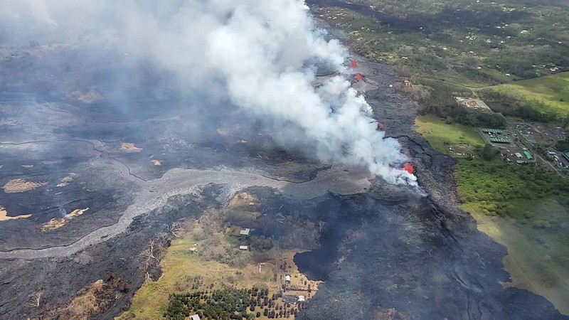
Lava has been coming out of the East Rift Zone mainly within the Leilani Estates subdivision since May 3.
A flow originating near the center of the subdivision is moving to the northeast in a development that could threaten Highway 132, an important access road for authorities and an evacuation route for remaining residents.
The flow from fissure 21 has been moving north along Kaupili Street to about 200 yards south of Kahukai Street at the edge of the Leilani subdivision, “but the flows are sluggish in the northeast direction,” said county spokeswoman Janet Snyder.
Wendy Stovall, a volcanologist with the U.S. Geological Survey, said lava in the area has built up into a pond that is 14 meters above surrounding ground level and is inflating. Stovall expects minor overflows but not rapid movement.
Another lava breakout from the same fissure system has occurred nearer to Mohala Street, according to Snyder, and fissure 3 in the same area has also been active.
“If fissures start opening up north, we may have to look at inundation of (Highway) 132,” she said. That highway extends from Pahoa village to Kapoho, and has become an increasingly important transportation route since lava severed Highway 137 on the Puna coast south of Pohoiki.
If Highway 132 is cut near its intersection with Pohoiki Road, Highway 137 along the coast from Kapoho to Hawaiian Beaches would become the last remaining route in and out of the Pohoiki and Kapoho areas.
Snyder said scientists are waiting for data from an observation overflight, and expect to have more details about the potential threat to Highway 132 later today.
Lava from fissure 22 continues to feed one lava river that is flowing into the ocean, while fissures 6 and 13 are feeding a second ocean entry, she said.
Kilauea Lower East Rift Zone Fissures and Flows, May 24 by Honolulu Star-Advertiser on Scribd
Meanwhile, fissures 7 and 21 are feeding a perched lava pond and flow of pāhoehoe lava — basaltic lava with a smooth or ropy surface — that has advanced eastward covering most of the area bounded by Leilani Blvd, Mohala St., and the fissure line, according to the Hawaiian Volcano Observatory. Fissure 17 continues to spatter weakly, while Fissures 19 and 23 are no longer active.
Lava flowing in the Lower East Rift Zone has so far destroyed at least 47 structures, and Snyder said it has covered an estimated 15,000 acres.
At the Kilauea summit about 25 miles away, there were a series of strong explosions starting Thursday night at 6 p.m. and continuing today, but very few earthquakes, she said. Those ash eruptions have not released any lava, but have scattered a layer of ash across Pahala and other communities in Kau.
The National Weather Service issued an alert at 11:03 a.m. that trace ashfall remains possible from Kilauea. The communities of Pahala, Wood Valley and Naalehu are particularly likely to receive ash fallout as trade winds push the ash southwest from Kilauea.
Volcanic gas emissions remain very high from the fissure eruptions. Additionally, trade winds are forecast to slow over the weekend, creating hazardous air quality and decreased visibility conditions throughout the lower east rift zone, Hawaii County Civil Defense said. Volcanic gases, vog and ash emissions may increase over the weekend with higher levels of sulfur dioxide pooling in areas downwind of the vents, the agency said.
9 A.M.
A lava flow originating near the center of the Leilani Estates subdivision is moving to the northeast in a development that could threaten Highway 132, an important access road for authorities and an evacuation route for remaining residents.
The flow from fissure 21 has been moving north along Kaupili Street to about 200 yards south of Kahukai Street at the edge of the Leilani subdivision, “but the flows are sluggish in the northeast direction,” said county spokeswoman Janet Snyder.
Another lava breakout from the same fissure system has occurred nearer to Mohala Street, she said, and fissure 3 in the same area has also been active.
“If fissures start opening up north, we may have to look at inundation of (Highway) 132,” she said. That highway extends from Pahoa village to Kapoho, and has become an increasingly important transportation route since lava severed Highway 137 on the Puna coast south of Pohoiki.
If Highway 132 is cut near its intersection with Pohoiki Road, Highway 137 along the coast from Kapoho to Hawaiian Beaches would become the last remaining route in and out of the Pohoiki and Kapoho areas.
Snyder said scientists are waiting for data from an observation overflight, and expect to have more details about the potential threat to Highway 132 later today.
Lava from fissure 22 continues to feed one lava river that is flowing into the ocean, while fissures 6 and 13 are feeding a second ocean entry, she said.
Meanwhile, fissures 7 and 21 are feeding a perched lava pond and flow of pāhoehoe lava — basaltic lava with a smooth or ropy surface — that has advanced eastward covering most of the area bounded by Leilani Blvd, Mohala St., and the fissure line, according to the Hawaiian Volcano Observatory. Fissure 17 continues to spatter weakly, while Fissures 19 and 23 are no longer active.
Lava flowing in the Lower East Rift Zone has so far destroyed at least 47 structures, and Snyder said it has covered an estimated 15,000 acres.
At the Kilauea summit about 25 miles away, there were a series of strong explosions starting Thursday night at 6 p.m. and continuing today, but very few earthquakes, she said. Those ash eruptions have not released any lava, but have scattered a layer of ash across Pahala and other communities in Kau.
The National Weather Service issued an alert at 11:03 a.m. that trace ashfall remains possible from Kilauea. The communities of Pahala, Wood Valley and Naalehu are particularly likely to receive ash fallout as trade winds push the ash southwest from Kilauea.
Volcanic gas emissions remain very high from the fissure eruptions. Additionally, trade winds are forecast to slow over the weekend, creating hazardous air quality and decreased visibility conditions throughout the lower east rift zone, Hawaii County Civil Defense said. Volcanic gases, vog and ash emissions may increase over the weekend with higher levels of sulfur dioxide pooling in areas downwind of the vents, the agency said.
Facebook not showing Honolulu Star-Advertiser headlines in your news feed? Here’s how to fix it.


