Flood advisories in effect for Big Isle, Kauai

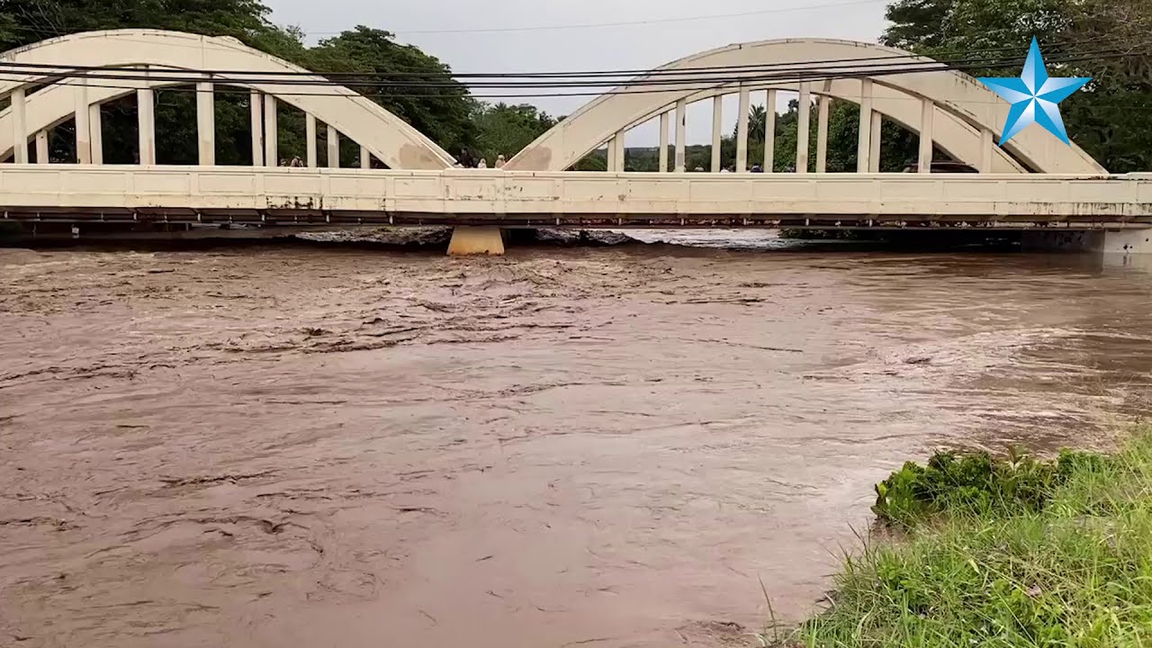

CRAIG T. KOJIMA / CKOJIMA@STARADVERTISER.COM
A rescue crew member searched for a missing person who was swept away into Waihona Stream in the Pearl City area.

JAMM AQUINO / JAQUINO@STARADVERTISER.COM
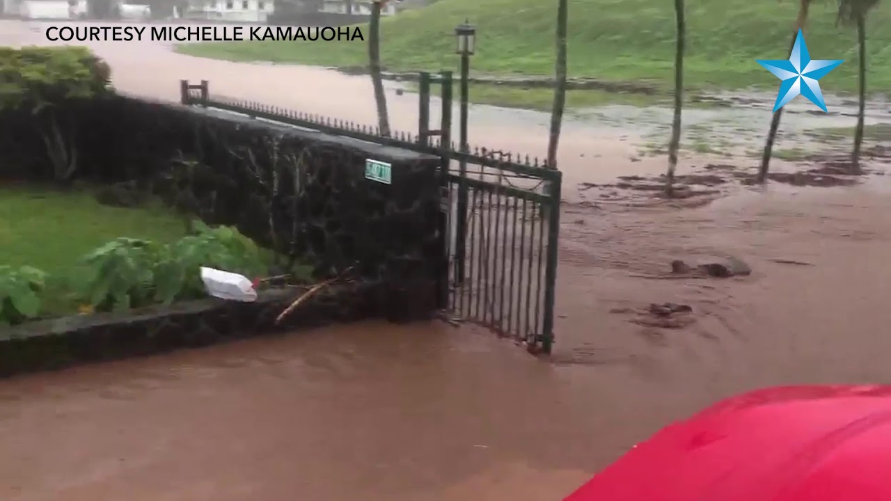
Flooding continues to get worse on Haleiwa Road near the Hele gas station.

CRAIG T. KOJIMA / CKOJIMA@STARADVERTISER.COM
Concerned people watched as HFD searched Waihona Stream in the Pearl City area for a missing person who was swept away.

CRAIG T., KOJIMA / CKOJIMA@STYARADVERTISER.COM
A fire truck crossed Heeia stream in Windward Oahu this morning.

CRAIG T. KOJIMA / CKOJIMA@STARADVERTISER.COM
Heeia stream was swollen today as a strong thunderstorm passed over Oahu.

CRAIG T. KOJIMA / CKOJIMA@STARADVERTISER.COM
Heeia stream, normally 15 feet wide, grew to 200 feet wide this morning.

CRAIG T. KOJIMA / CKOJIMA@STARADVERTISER.COM
Part of a hillside in Heeia eroded this morning as a strong thunderstorm passed over Oahu.

CRAIG T. KOJIMA / CKOJIMA@STARADVERTISER.COM
Vehicles drove through standing water this morning on Kamehameha Highway near Heeia.

NATIONAL WEATHER SERVICE
A series of satellite images Tuesday morning showed areas of moisture over the Hawaiian islands.

NATIONAL WEATHER SERVICE
A series of radar images through 9:18 a.m. Tuesday showed areas of rainfall, with particularly heavy rainfall over Windward Oahu, throughout the islands.

PHOTO COURTESY HIPI SULUNGA
Both lanes of Kamehameha Highway northbound were closed heading into Hauula this afternoon, at the bridge, according to Hauula resident Hipi Sulunga.


UPDATE: 9:45 a.m.
The National Weather Service this morning canceled the flash flood warning for Kauai as well as the Puna and Kau districts of Hawaii island, and replaced them with a flood advisory, effective through 11:30 a.m. today.
At 9:11 a.m., radar indicated the heaviest rain has ended over Kauai, forecasters said. However, however isolated showers across the island could still cause ponding issues and maintain elevated stream levels.
Kuhio Highway near the Hanalei Bridge remains closed this morning due to elevated river levels, county officials said. Motorists are asked to drive with caution due to hazardous road conditions.
An earlier flash flood warning for the Puna and Kau districts for Hawaii island has also been replaced with a flood advisory, effective through 11:30 a.m. today.
At 9:06 a.m., radar indicated the rain over the Puna and Kau districts had weakened, with some showers remaining that could cause ponding on roadways. Radar shows the heaviest showers currently over the Hawai‘i Volcanoes National Park, with rates up to 2 inches per hour.
Don't miss out on what's happening!
Stay in touch with top news, as it happens, conveniently in your email inbox. It's FREE!
Forecasters still expect widespread showers, some locally heavy, statewide today as a slow-moving low-pressure system lingers west of Kauai. A flash flood watch for all islands remains in effect through 6 p.m. Friday.
8:40 a.m.
The flash flood watch for all islands has been extended through Friday afternoon.
A low-pressure system west of Kauai will keep the atmosphere moist and unstable, extending the potential for locally heavy rainfall, the National Weather Service said.
6:36 a.m.
The flash flood warning for Hawaii island has been expanded and extended.
Radar at 6:36 a.m. showed heavy rain over and moving onshore in the Puna and Kau districts from the south with rain falling at rates up to 3 inches per hour, the National Weather Service said. Ponding is already occurring along Route 130 between Pahoa and Keaau in the Puna District.
Some locations that will experience flash flooding include Hawaiian Paradise Park, Hawaii Volcanoes National Park, Volcano, Glenwood, Mountain View, Hawaiian Acres, Orchidland Estates, Pahoa, Keaau, Wood Valley, Pahala, Punaluu Beach, Kawa Flats, Naalehu, Fern Forest, Eden Roc, Fern Acres, Kalapana and Kurtistown.
6:10 a.m.
A flash flood warning is in effect for Hawaii island through 8 a.m. today and the flash flood warning for the island of Kauai has been extended through 9:45 a.m.
At 5:26 a.m., radar showed torrential rain anchored over Puna, with over 6 inches of rain having fallen over Puna in the last couple of hours, according to the National Weather Service. Rain was falling at a rate of 2 to 3 inches per hour and flash flooding is occurring or expected to begin shortly.
Some locations that will experience flash flooding include Hawaiian Paradise Park, Hawaiian Acres, Glenwood, Orchidland Estates, Mountain View, Pahoa, Keaau, Eden Roc, Fern Acres, Fern Forest, Ainaloa, Kurtistown, Kalapana, Leilani Estates, Nanawale Estates, Hawaiian Beaches and Isaac Hale Beach Park.
This flash flood warning replaces the previously issued flood advisory that was in effect for the island of Hawaii in Hawaii County.
Radar at 6:20 a.m. also showed heavy showers continuing to develop and move over Kauai from the south, weather officials said. Rain was falling at a rate of up to 2 inches per hour.
Kuhio Highway remains closed at the Hanalei Bridge, and the Keapana Bridge is impassable. Stream levels remain elevated across the island.
The heavy rains may cause rock and mudslides in steep terrain areas.
Residents and visitors on both islands are advised to stay away from streams, rivers, drainage ditches and culverts, even if they are currently dry.
1:25 a.m.
The National Weather Service has issued a flood advisory the eastern side of Hawaii island until 4 a.m.
“At 1:02 a.m. radar indicated heavy rain over eastern portions of the Big Island from Volcano to Keaau. Rain was falling at a rate of 1 to 2 inches per hour,” the advisory said.
The advisory includes Hawaiian Paradise Park, Hawaiian Acres, Glenwood, Orchidland Estates, Mountain View, Pahoa, Keaau, Volcano, Fern Acres, Fern Forest,Ainaloa, Kurtistown, Kalapana, Leilani Estates, Nanawale Estates, and Hawaiian Beaches.
12:40 a.m.
The National Weather Service has extended the flash flood warning for Kauai until 3:45 a.m.
“At 12:32 a.m., water levels at the Hanalei River Bridge stream gauge are still elevated, and Kuhio Highway remains closed at the Hanalei Bridge,” forecasters said. “Additional rainfall continues to develop and move over Kauai from the southeast with rates of up to 2 inches per hour.”
The warning includes Lihue, Kapaa, Kalaheo, Kekaha, Princeville, Kilauea, North Fork, Wailua Tra.ils, Alakai Swamp Trails, Lawai, Omao, Kokee State Park, Wailua Homesteads, Hanalei, Hanapepe, Wainiha, Na Pali State Park, Koloa, Haena, Waimea and Wailua.
The entire state remains under a flash flood watch until 6 p.m. Wednesday.
WEDNESDAY, 12:20 a.m.
The flash flood warning for Haleiwa has expired.
However the National Weather Service has issued a flood advisory for a small area of East Maui until 2 a.m.
“At 10:56 p.m. (Tuesday), radar indicated nearly stationary heavy rain over the eastern tip of windward Maui, impacting the area east of a line from Nahiku to Kaupo, including the Hana Highway,” the advisory said. “Rainfall rates up to 2 inches per hour will lead to very low visibility.”
The advisory includes Kipahulu, Hana, Nahiku, Kaupo and Hamoa.
TUESDAY, 11:45 p.m.
The evacuation order for Haleiwa has been canceled.
The Honolulu Department of Emergency Management announced at 11:43 p.m. Tuesday that all roads in the area are open, the flooding has subsided, and residents may return home.
The overnight evacuation shelter at Wahiawa District Park, 1129 Kilani Ave. in Wahiawa remains open, but the temporary evacuation site at Waialua High and Intermediate School is closed.
A flash flood warning remains in effect for Haleiwa until 12:30 a.m. Wednesday but heavy rains in the area have subsided.
9:30 p.m.
Haleiwa remains under a flash flood emergency tonight.
The National Weather Service said a gauge on the Kaukonahua Stream in Waialua reported a rapid rise in water levels tonight, which could lead to significant flooding of Otake Camp in Waialua. Portions of Haleiwa town remain evacuated with roadways still closed and standing water along Haleiwa Road between Waialua Beach Road and Smiley Place.
Rainfall has eased over the North Shore this evening but Opaeula Stream continues to flow at a high level. Locations that may experience flash flooding include Haleiwa, Waialua, Otake Camp, Helemano Housing, Waimea Valley and Mokuleia.
Oahu remains under a flash flood warning through 12:30 a.m. Wednesday.
A flash flood warning for Kauai has also been extended to 12:45 a.m. Wednesday. Kuhio Highway remains closed at the Hanalei Bridge with some homes flooded in Wainiha.
Rivers and streams continue to run high on Kauai. Additional rainfall continues to develop and move over Kauai from the southeast with rates of 1 to 2 inches per hour.
7:40 p.m.
The fire department is continuing to search for a small-framed person of unknown gender. The Honolulu Fire Department received a single report at 4:27 p.m. of a person spotted in Waihona Stream near Leeward Community College, but this was not confirmed by HFD personnel.
HFD responded with seven units and 26 personnel, along with its helicopter, Air 3.
UPDATE: 6:30 p.m.
Oahu’s flash flood warning has been extended to 9:30 tonight and Kauai’s flash flood warning has been extended to 9:45 tonight.
The National Weather Service said rainfall over Windward Oahu has eased but streams continue to run high, especially Waiahole Stream and Kahana Stream.
Opaeula Stream in Haleiwa continues to flow at a very high level and the bridge over Opaeula Stream at Haleiwa Road was inundated by several feet of water this afternoon.
Kuhio Highway remains closed at Hanalei Bridge on Kauai. Some homes have been flooded on Alamihi Road in Wainiha. Additional rainfall has continued to move over Kauai from the southeast with rates of 1 to 2 inches per hour.
Gov. David Ige also signed an emergency proclamation for the state this afternoon. The proclamation will free up state funds to assist those across the state impacted by the heavy rainfall and flooding.
6:15 p.m.
The city has set up short-term evacuation sites for those affected by the flooding on the North Shore. The city is emphasizing that these are not shelters, merely gathering places with access to restrooms and parking.
Evacuees should try to stay with family and friends where possible. The city is assessing the need for overnight shelter, and locations will be posted as the need is identified.
Pets are allowed at the evacuation sites.
These short-term sites are: Waialua High and Intermediate School parking lot; Wahiawa District Park parking lot; Waiahole Elementary School parking lot; Kahuku Elementary School parking lot; Kahuku Elementary School parking lot; Kahaluu Community Park parking lot; and Kaneohe District Park parking lot.
UPDATE: 5:50 p.m.
The Honolulu Fire Department responded to a report of a person swept away at 4:32 p.m. in Waihona Stream near Leeward Community College.
HFD personnel are searching downstream. The location given is 96-1088 Waihona St. Eight units have been involved in the search-and-rescue operation.
On the Windward side, Waiahole Stream overflowed its banks earlier in the day, police said.
A general manager at the Waiahole Poi Factory said that the water flooded the shop, which was a half foot deep at 11 a.m., but is now 2 feet deep.
He said, “Supposedly the bridge went crack.” He said he saw it on Instagram, but police would not allow them to go over the bridge.
Joshua Wilson, general manager, said the river was overflowing and manholes in the middle of the road were overflowing. “It’s kind of a river,” he said of the roadway near the shop.
Police at the Kaneohe station could not confirm whether there was damage to the bridge, but said the rain has stopped and the water has likely receded.
5:45 p.m.
The Department of Education said Hauula, Kaaawa and Waiahole elementary schools on Oahu and Haiku Elementary on Maui will be in full distance learning on Wednesday due to flooding and heavy rain conditions.
5:30 p.m.
The floodwaters are due to arrive in Haleiwa anywhere from 5 p.m. to 7 p.m. tonight and may stick around for awhile, said National Weather Service meteorologist Will Ahui.
Police are currently assisting with the evacuation in Haleiwa and trying to get everyone out.
Ahui said that a rain gauge in the Opaeula Stream topped out at almost 16 feet, but the flood level is 12.2 feet, which is the level at which the floodwaters will begin to overflow its banks.
That means floodwaters exceeded the banks of the stream by 4 feet.
The stream empties out in Haleiwa Town, along Kamehameha Highway near the area where the shrimp trucks are located.
The flash flood emergency and evacuation orders are because of the enormous amount of rainfall in the Koolaus with additional storms moving up along the mountain range toward that area, Ahui said.
The Honolulu Fire Department said it has responded to 16 weather-related calls from 8 a.m. to 1 p.m., with 14 water evacuations, one downed tree and one downed power line.
UPDATE: 5 p.m.
A flash flood warning is in effect for Kauai until 6:45 tonight.
Radar indicated heavy rain over the island of Kauai and rain was falling at a rate of 1.5 to 2.5 inches per hour this afternoon.
The gage on the Hanalei River shows the water level rising rapidly and the water is expected to reach the road near the Hanalei Bridge soon.
4:25 p.m.
The Honolulu Department of Emergency Management issued the following emergency alert:
“Catastrophic flooding from Opaeula Stream. Evacuate now from Haleiwa Town, including Weed Circle to Paalaa Rd, Joseph P Leong Highway to the ocean.
“Evacuation points open at Wahiawa District Park and Waialua High. You are in danger. Leave now.”
The FLASH FLOOD EMERGENCY continues for #HALEIWA below the OPAEULA STREAM. This is a PARTICULARLY DANGEROUS SITUATION. SEEK HIGHER GROUND NOW! If you live near #HALEIWA FOLLOW THE EVACUATION ORDERS from @Oahu_DEM, @honolulupolice, and HFD even if its not raining near you. #HIwx pic.twitter.com/km5zWc5998
— NWSHonolulu (@NWSHonolulu) March 10, 2021
3:30 p.m.
The National Weather Service has extended the flash flood warning for Oahu to 6:30 p.m.
At 3:21 p.m., radar indicated heavy rain over Oahu’s windward side and North Shore. Rain was falling at a rate of 2.5 to 3.5 inches per hour. Flash flooding is already occurring.
Some locations that will experience flash flooding include Punaluu, Waikane, Kaaawa, Hauula, Waiahole, Wahiawa, Mililani, Laie, Kahaluu, Ahuimanu, Kahuku, Kaneohe, Haleiwa, Waialua, Kaneohe Marine Base, Kalihi, Maunawili, Kailua, Manoa and Kahana Valley State Park.
A flash flood watch for all isles has also been extended to 6 p.m. Wednesday.
2:30 p.m.
A strong thunderstorm is about to impact Kauai, according to the National Weather Service.
At 2:20 p.m., forecasters said a strong thunderstorm was located near Moloaa, or 20 miles north of Lihue, moving west at 20 mph. Wind gusts up to 50 mph and pea-sized hail are possible with this storm as it moves along the north shore of Kauai in the next hour — from 2:30 p.m. to 3:30 p.m.
Locations impacted include Princeville, Kilauea, Anahola, Moloaa, Hanalei, Na Pali State Park, Haena, Wainiha, Alakai Swamp Trails and Kalihiwai.
2 p.m.
The NWS has extended the flood advisory for Hawaii island through 5 p.m. today.
At 1:42 p.m., radar indicated heavy rain continuing over the South Hilo and Puna Districts on Hawaii island. The highest rain rates of 1 to 2 inches per hour were over the lower slopes of the Puna District from Kalapana to Kapoho.
Rainfall over the Kau District, meanwhile, has been easing, forecasters said.
Locations in the advisory include but are not limited to Hilo, Hawaiian Paradise Park, Volcano, Hawaii Volcanoes National Park, Wood Valley, Glenwood, Pahala, Mountain View, Punaluu Beach, Hawaiian Acres, Kawa Flats, Pohakuloa Training Area, Orchidland Estates, Keaau, Naalehu, Pahoa, Papaikou, Pepeekeo and Honomu.
A flash flood warning for Oahu, the highest alert, remains in place until 4:45 p.m. today, and a flash flood watch for all isles through Wednesday morning.
1 p.m.
The NWS has extended the flash flood warning for Oahu another three hours to 4:45 p.m. today.
At 1:25 p.m., radar and rain gauges continue to show rain falling at 2.5 to 3.5 inches per hour over windward Oahu, forecasters said. Several roads also remain closed in the area.
The Hawaii Department of Transportation said in a 1 p.m. tweet that the right lane of Pali Highway, Kailua-bound, is blocked before the hairpin turn due to a landslide.
Additionally, crews are working to clear debris on Kamehameha Highway between Pupukea and Sunset Beach on Oahu’s North Shore. Emergency management officials have also reported Kamehameha Highway closed at Pipilani Place in Hauula, and two homes with flood damage in the area.
The NWS also has a flood advisory for Hawaii island in place until 2 p.m. today.
At about 1 p.m., radar showed rain falling at 2.5 to 3.5 inches per hour over windward Oahu.
Some locations that will experience flash flooding include Waikane, Waiahole, Kahaluu, Kaaawa, Ahuimanu, Punaluu, Hauula, Kaneohe, Kaneohe Marine Base, Wahiawa, Laie, Kalihi, Maunawili, Kailua, Manoa, Kahuku, Palolo, Waimanalo, Haleiwa and Hawaii Kai.
On Hawaii island, 12:35 p.m. radar indicated heavy rain continuing over the South Hilo, Puna, and Kau districts of Hawaii island. The highest rain rates were in the Kau district near Pahala and Wood Valley, with rates of 1 to 2 inches per hour. Rainfall is expected to continue for several hours more as rain continues to move ashore from the southeast, forecasters said.
A flash flood watch is also in effect for Hawai County, and all isles, through 6 a.m. Wednesday.
11 a.m.
The Polynesian Cultural Center and Hukilau Marketplace will be closed today due to the severe weather conditions impacting the island of Oahu, owners said today, and out of an abundance of caution for employees and guests.
The NWS has extended the flash flood warning for Oahu to 1:45 p.m. today.
Also, the Hawaii Department of Transportation tweeted this morning that Kamehameha Highway is closed between Wailehua Road and Waikane Store in both directions. A contra-flow has been set up on the highway in the area of Kualoa Ranch.
>> RELATED STORY: Brown water advisories posted for Maui and Kauai islands
Also, NWS has issued a flood advisory for Hawaii island, in effect until 2 p.m. today.
At 10:55 a.m., radar indicated heavy rain over the South Hilo, Puna, and Kau Districts on Hawaii island. Rain was falling at a rate of 1 to 2 inches per hour. Rainfall will continue for several hours more as rain continues to move ashore from the southeast, forecasters said.
Locations in the advisory include but are not limited to Hilo, Hawaiian Paradise Park, Volcano, Hawaii Volcanoes National Park, Wood Valley, Glenwood, Pahala, Mountain View, Punaluu Beach, Hawaiian Acres, Kawa Flats, Pohakuloa Training Area, Orchidland Estates, Keaau, Naalehu, Pahoa, Papaikou, Pepeekeo and Honomu.
A flood advisory means nuisance flooding is occurring and may be upgraded to a flash flood warning if flooding worsens. The public should stay away from streams, drainage ditches and low-lying areas prone to flooding. Rainfall and runoff will also cause hazardous driving conditions due to ponding, reduced visibility and poor braking action.
10:30 a.m.
The National Weather Service has extended the flash flood warning for Oahu to 1:45 p.m. today.
At 10:31 a.m., radar and automated rain gauges indicated heavy rain falling over windward Oahu. Rain was falling at a rate of 3 to 4 inches per hour.
Some locations that will experience flash flooding include Waikane, Waiahole, Kahaluu, Kaaawa, Ahuimanu, Punaluu, Hauula, Kaneohe, Kaneohe Marine Base, Wahiawa, Laie, Kalihi, Maunawili, Kailua, Manoa, Kahuku, Palolo, Waimanalo, Haleiwa and Hawaii Kai.
Officials warn the public to stay away from streams, rivers, drainage ditches, and culverts, even if they are currently dry. The public should not cross fast-flowing or rising water by car or foot. Heavy rains may also cause rockslides and mudslides in steep terrain.
10 a.m.
The National Weather Service has issued an alert, warning of a strong thunderstorm that will impact Oahu.
At about 10 a.m., officials said a strong thunderstorm was located just offshore of Kahaluu, Waiahole, and Waikane, and moving west at 10 mph. Winds in excess of 40 mph, and pea-sized hail are possible with this storm.
Locations affected include Ahuimanu, Waimanalo, Kailua, Manoa, Maunawili, Kaneohe, Waikane, Kaneohe Marine Base, Waiahole, Kahaluu, Kaaawa, Palolo, Kalihi, Heeia, Kahana Valley State Park, Makiki-Tantalus, Bellows Air Force Station, Nuuanu and Kualoa.
PREVIOUS COVERAGE
The National Weather Service has replaced the flood advisory for the island of Oahu with a flash flood warning, effective through 10:30 a.m.
At 9:13 a.m, radar and automated rain gauges indicated heavy rain falling over Windward Oahu. Rain was falling at a rate of 3 to 4 inches per hour.
Some locations that will experience flash flooding include Waikane, Waiahole, Kahaluu, Kaaawa, Ahuimanu, Punaluu, Hauula, Kaneohe, Kaneohe Marine Base, Wahiawa, Laie, Kalihi, Maunawili, Kailua, Manoa, Kahuku, Palolo, Waimanalo, Haleiwa and Hawaii Kai.
A flash flood warning means there will be flooding drainages, streams, rivers, roads, properties, and other low-lying areas. Landslides are also possible in steep terrain.
The public should not attempt to cross fast-flowing or rising water by vehicle or foot.
A flash flood watch also remains in place for all islands through 6 a.m. Wednesday. Up to 3 more inches of snow is expected at Big Isle summits, where a winter weather advisory also remains in place through 6 a.m. Wednesday.
A high surf advisory also remains in place for east shores of all isles from Kauai to Hawaii island through 6 p.m. today due to strong trades.
Surf of 8 to 10 feet is expected along east shores, bringing strong rip currents and breaking waves, and beachgoers should heed all advice from safety officials.
Forecasters expected mostly cloudy skies today, and widespread showers to continue through tonight, with highs from 78 to 83 degrees Fahrenheit, along with strong east to southeast winds of 15 to 30 mph. Lows tonight dip to 65 to 70.
Rainfall gauges in the last 24 hours ending at 8 a.m. today recorded 16.63 inches of rain at West Wailuaiki on Maui, 10.13 inches at Piihonua on Hawaii island, 8.42 inches at Mount Waialeale on Kauai, and 4.51 inches at Punaluu Stream on Oahu.
Maui officials, meanwhile, said in a news release this morning that damage assessments are ongoing after heavy rains Monday caused flooding and the overtopping of the Kaupakalua Reservoir and Dam, forcing the evacuation of some 150 downstream homes.
Maui Mayor Michael Victorino said flood waters destroyed Peahi Bridge and heavily damaged Kaupakalua Bridge in Haiku. The flood waters also damaged or destroyed at least a half dozen homes.
“This has been unprecedented flooding, and we will be making damage assessments today,” Victorino said in the release. “I ask everyone to stay vigilant and be safe.”
Residents who were evacuated from their homes on Monday are asked not to return until there is an “all clear” announcement. The evacuation remains in effect for residents in the vicinity and downstream of Kaupakalua Dam.
Additionally, a power outage was reported at 6:12 a.m. in Haiku, officials said, affecting more than 1,300 customers.
People are also advised to stay off roads as much as possible and exercise extreme caution, watching out for debris and landslides — and to beware of possible downed power lines. People should stay at least 30 feet away from downed power lines and assume they are energized and dangerous.
East Maui Irrigation Co. officials monitored the Kaupakalua Reservoir overnight, and water levels remained above normal, but roughly 3 feet below the top of the dam. Jos


