Hurricane, tropical storm weaken in East Pacific; no threat to Hawaii
COURTESY NOAA
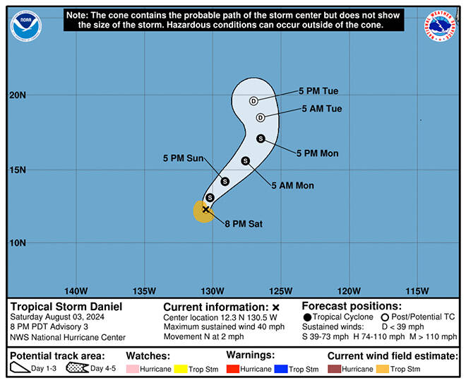
The five-day forecast of Tropical Storm Daniel as of Saturday afternoon.
COURTESY NOAA
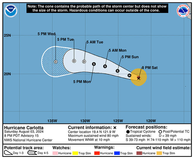
The five-day forecast of Hurricane Carlotta as of Saturday afternoon.
COURTESY NOAA
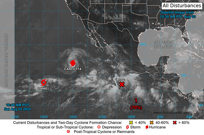
Three storm systems churn today in the East Pacific, including Hurricane Carlotta and Tropical Storm Daniel.


UPDATE: 5:40 p.m.
Hurricane Carlotta is weakening as it moves over cooler waters in the East Pacific, the National Hurricane Center’s forecasters said.
As of about 5 p.m. today, Carlotta had maximum sustained winds of 80 mph, down 10 mph from its peak early this morning, and was centered about 810 miles west-southwest of the southern tip of Baja California.
The storm had hurricane-force winds extend up to 25 miles from the center and tropical storm-force winds extend out up to 90 miles, forecasters said.
“Gradual weakening is expected tonight, with a more steady rate of weakening forecast on Sunday,” they said.
That weakening is expected to continue and Carlotta is forecast to be dissipated by Wednesday before reaching the Central Pacific.
Don't miss out on what's happening!
Stay in touch with breaking news, as it happens, conveniently in your email inbox. It's FREE!
The Miami-based hurricane center was also monitoring Tropical Storm Daniel in the Eastern Pacific which is expected to dissipate over the next few days far from any land mass.
At 5 p.m., the storm was a minimal tropical storm with maximum sustained winds of 40 mph about 1,540 miles west-southwest of the southern tip of Baja California.
The center is also watching another East Pacific storm system that could become tropical cyclone in the next week. The system, a few hundred miles to the south of Mexico, has a 90% chance of becoming a tropical cyclone within a week as it moves west-northwest at 10 to 15 mph and away from Mexico, forecasters said.
PREVIOUS COVERAGE
Two tropical cyclones are churning in the East Pacific today, but forecasters expect both to dissipate far from Hawaii next week.
Hurricane Carlotta, which formed Friday, was likely at its peak today with maximum sustained winds of 90 mph, according to the National Hurricane Center. It was centered about 705 miles south of the southern tip of Baja California, moving to the west-northwest at 14 mph this morning.
Carlotta is compact hurricane with hurricane-force winds extending up to 10 miles from its center and tropical storm-force winds extending up to 90 miles, the Miami-based center said.
“Little change is strength is expected today, but weakening should begin by tonight,” forecasters said today.
At the end of the current five-day forecast on Thursday, the storm is expected to have dissipated to a “post-tropical remnant low” with 25 mph winds as it encounters cooler ocean water and wind shear before reaching the Central Pacific.
Forecasters say Tropical Storm Daniel, which formed today, is “expected to be a short-lived storm” in the Eastern Pacific, as it dissipates over the next few days far from any land mass.
Daniel had maximum sustained winds of 40 mph this morning and was centered about 1,500 miles west=southwest of the southern tip of Baja California.
“Some slight strengthening is possible during the next day or two with some gradual weakening expected thereafter,” hurricane center forecasters said.
The center is also watching another East Pacific storm system that could become tropical cyclone in the next week.
The system, a few hundred miles to the south of Mexico, has a 90% chance of becoming a tropical cyclone within a week as it moves west-northwest at 10 to 15 mph and away from Mexico, forecasters said.


