Big Isle mayor envisions ‘whole new community’ for Puna; crews work to open new evacuation routes


DENNIS ODA / DODA@STARADVERTISER.COM
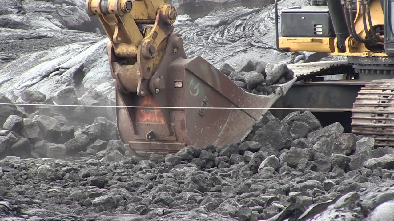
John Makoff, regional manager for Goodfellow Bros., walked Friday on rocks that were once the lava flow that covered Chain of Craters Road. Rocks are pulverized to create a drivable road as an alternate emergency evacuation route.

U.S. GEOLOGICAL SURVEY
Fissure 8 continues to feed lava into multiple flow lobes. One lobe is advancing through agricultural land toward the northeast, as shown in this image taken from a helicopter Friday morning.

U.S. GEOLOGICAL SURVEY
The fissure 8 lava fountain appeared to have decreased in height from previous sustained heights of 260 feet, as viewed on Friday from the intersection of Nohea and Leilani streets.

U.S. GEOLOGICAL SURVEY
A pair of radar amplitude images that were acquired by the Italian Space Agency’s Cosmo-SkyMed satellite system illustrate changes to the caldera area of Kilauea Volcano that occurred between May 23 and May 31.

HILO >>
Hawaii island Mayor Harry Kim plans to help refugees from the May 3 Kilauea eruption by launching a rapid rehousing initiative comparable to the resettlement effort that rolled out after a tsunami devastated portions of Hilo in 1960.
Kim told listeners in a briefing at the Hawaii County Civil Defense headquarters Friday morning that the authorities in 1960 developed a strategy called the Kaikoo Project that was completed within six months, said Kim’s spokeswoman Janet Snyder.
That plan resulted in clearing or redevelopment of hundreds of acres of land, and eventually resulted in new housing in Waiakea outside the tsunami inundation area for people who had been displaced. It also led to the development of the Kaikoo Mall in urban Hilo, and the creation of what is now known as the Kanoelehua Industrial area in Waiakea.
“Harry says he’s going to make a whole new community for the people of Puna, to give them hope that there’s a better tomorrow,” Snyder said. “He says, ‘If they could create a plan in six months, so can we.’”
The county continued its efforts Friday to evacuate the Kapoho area including the Vacationland subdivision and homes along Highway 137 as lava from a fissure in Leilani Estates advanced to within a half-mile of the last evacuation route out of the area.
Don't miss out on what's happening!
Stay in touch with top news, as it happens, conveniently in your email inbox. It's FREE!
Kilauea Lower East Rift Zone Fissures and Flows, June 1 by Honolulu Star-Advertiser on Scribd
Given the dynamic nature of Kilauea’s lower East Rift Zone eruption, with changing vent locations, fissures starting and stopping, and varying rates of lava effusion, map details shown here are accurate as of the date/time noted. Shaded purple areas indicate lava flows erupted in 1840, 1955, 1960, and 2014-2015. (see large map)
>> Lava crosses Highway 137, limits access to Kapoho, Vacationland
>> Leilani Estates evacuee dies by apparent suicide
>> Big Isle mayor envisions ‘whole new community’ for Puna
>> Hawaii island resident smashes pickup into hardened lava
>> Allegedly intoxicated man arrested after crashing into hardened lava
>> Arrests possible for Leilani Estates holdouts
>> Leilani Estates lava might not be part of the eruption that began in 1983
>> Kau residents irritated by ashfall from volcano
>> Puna man ‘just wanted to live’ after nearly losing leg to lava bomb
RELATED PHOTOS AND VIDEOS
>> Live webcams from Hawaii island
>> Emergency lava route through Chain of Craters-Kalapana Road nearly complete, June 1
>> Changes occurring within Halemaumau crater, June 1
>> Pyroclasts inundate Leilani Estates as lava continues to flow, May 31
>> Hawaii Army National Guard Major Jeff Hickman provides an update, May 31
>> Leilani Estates residents talk about evacuating as lava advances, May 31
>> Hawaii Fire Department tracks lava from the air, May 30
>> Aerial view of lava flow in Leilani Estates, May 29
>> No break over holiday weekend for Kilauea, May 28
COMPLETE KILAUEA COVERAGE
>> Star-Advertiser volcano coverage
>> Kilauea Volcano YouTube playlist
The lava was approaching the intersection of Highways 137 and 132, a spot that is locally known as Four Corners. If it crosses Highway 137 as it appeared to be poised to do, it would isolate more than 500 homes in Kapoho and the surrounding area.
The lava flow from fissure 8 in Leilani Estates has been moving at a rate ranging from 70 to 120 yards per hour, and county officials predicted it could reach Four Corners on Friday or today.
The eruption already has forced the evacuation of much of the Leilani Estates subdivision and all of Lanipuna Gardens subdivision, which between them had more than 800 homes. So far, the May 3 eruption has destroyed 87 homes, county officials said Friday.
Snyder said Kim made his remarks about the Kaikoo Project and developing new housing during a closed-door briefing for federal, state and county officials who are assisting with the lava flow, but said she did not have any immediate information on specific plans for additional housing for evacuees.
The May 23, 1960, tsunami that prompted the Kaikoo Project was triggered by a huge earthquake in Chile that killed 61 people. It demolished much of downtown Hilo and wiped out a neighborhood known as Shinmachi town. Shinmachi, which stood on what is now open space in Wailoa State Park, was never rebuilt.
Kim’s comments had county Planning Director Michael Yee scrambling to answer reporters’ questions about what exactly the mayor has in mind.
“Obviously, people have lost their homes to the lava or certainly don’t want to return. Where are they going to move to?” Yee said. “That’s where I think the mayor was kind of throwing out there the old project from whenever. That was a different time, but clearly what he’s trying to tell us is you have this opportunity to really create new housing for folks that are going to need it, so throw whatever options you have out there.”
“Housing projects in the past could take years, between the permitting and everything,” Yee said. “People don’t have years to wait, and that’s what the mayor’s trying to tell us.”
Yee said his focus up to now has been to clear the way for development of tiny temporary emergency housing units that can be used to shelter people who have been evacuated from subdivisions that are threatened by lava and are now in shelters operated by the county.
The county is close to striking a deal with a nonprofit to allow 11 small housing units to be erected on property owned by Sacred Heart Church in Pahoa. Those units would not have electricity or plumbing, but would be served by a mobile hygiene center with showers and toilets, he said.
The second phase of that effort would add another 17 units to the project, and the county plans to enter into additional partnerships with other churches or nonprofits to relocate the evacuees out of the emergency shelters, he said.
Longer term, Yee said there is no one in state or county government who has experience coping with a crisis like this. “We don’t have an institutional knowledge how to carry this forward. We’re learning as we go.” He predicted the solution will be “multipronged.”
“I think there are multiple conversations happening with different groups that have different abilities to do things, and given that housing was already a challenge before this, this just adds to the challenge, so we just know we need to have more housing coming online over the next couple of years,” he said.
Emergency routes
In other developments, lava has burned down two buildings at the Puna Geothermal Venture, and state Department of Transportation officials said two emergency evacuation routes in Lower Puna should be completed today.
The Puna geothermal plant was taken offline and evacuated soon after the Leilani Estates eruption began, and officials removed roughly 50,000 gallons of pentane, a flammable gas similar to lighter fluid used in power generation at the plant.
On Wednesday a substation and adjacent warehouse that stored a drilling rig at the plant were covered by lava, according to a Thursday statement from Ormat Technologies, the Nevada company that owns the plant.
The main access road to the plant also has been covered and blocked by lava, but an alternative access road remains open.
Two geothermal wellheads also were destroyed Monday. Those geothermal wells had been plugged to prevent the accidental release of toxic gases by the lava flow.
Work on the emergency route through Chain of Craters Road that began Wednesday is expected to be completed for emergency use by today. That route linking the town of Kalapana to Highway 11 serves as an evacuation route through Hawai‘i Volcanoes National Park in the event that Highway 130 outside of Pahoa is cut off by lava.
Another alternate emergency route, being called the Pahoa-Kalapana Detour, offers a way around a section of Highway 130 that has been cracking.
That detour traverses through 3 acres of Sanford’s Service Center property north of Kamaili Road — also known as Opihikao Drive — and connects with the county-owned Alaili Road. It also should be ready for emergency use today, according to the state Department of Transportation.
The Associated Press contributed to this report.


