WEATHER BLOG: Oahu, Kauai County remain under flood watch as kona low lingers
JAMM AQUINO / JAQUINO@STARADVERTISER.COM
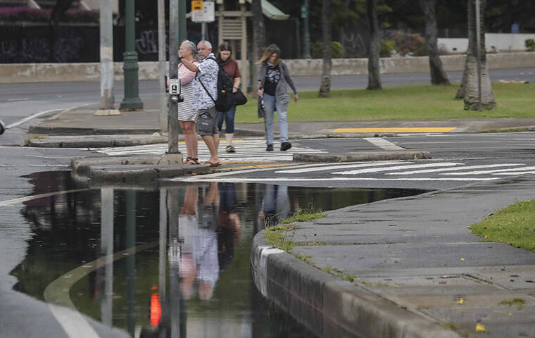
Pedestrians are reflected in floodwaters on Oahu today. Heavy rain and high winds continued to pound much of the state due to the lingering Kona low system south of the islands.
COURTESY NATIONAL WEATHER SERVICE
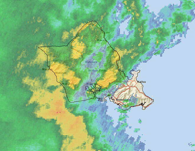
A radar image from early this afternoon showed a powerful line of showers moving over Oahu from the south. The National Weather Service issued a flash flood warning for Oahu until 4:15 p.m. as the band of showers approached the island.
COURTESY NATIONAL WEATHER SERVICE
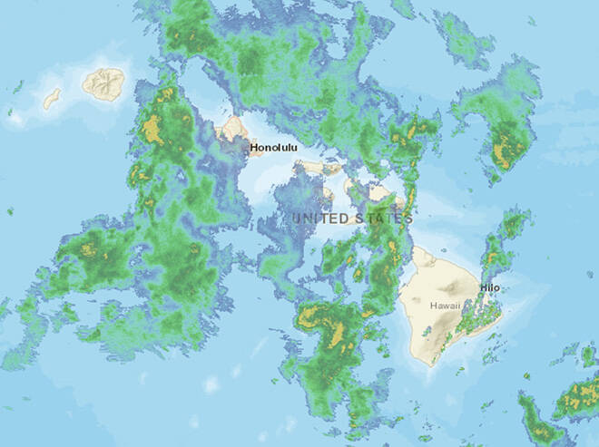
A powerful “kona low” storm was moving west over the Hawaiian islands, bringing abundant rain from the south over Maui County and Oahu early today.
CRAIG T. KOJIMA / CKOJIMA@STARADVERTISER.COM
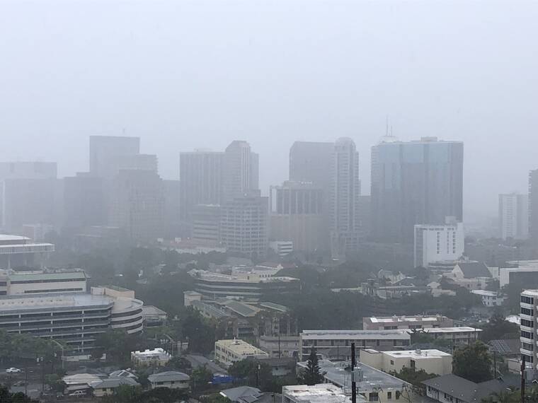
Skies were overcast on Oahu Sunday as showers began moving over urban Honolulu. The forecast for Oahu calls for strong winds and heavy rain to continue today into Tuesday.


EDITOR’S NOTE: See today’s story for the latest weather updates.
———
UPDATE: 4:50 am.
The flash flood warning for Oahu has expired but the island and Kauai County remain under a flood watch through Tuesday afternoon.
The National Weather Service in Honolulu says flash flooding caused by excessive rainfall remains possible on Kauai, Niihau and Oahu.
“Rain events of this size can cause catastrophic flooding and affect areas that do not usually flood,” the weather service says. “Low spots in roads will become dangerous and impassable due to severe runoff. Debris in streams and gulches may clog bridges and culverts resulting in dangerous flooding. Numerous landslides are expected in areas with steep terrain. Additional heavy rainfall on Oahu could cause severe flooding impacts, as six to ten inches of rain has fallen over the entire island since Monday.”
Don't miss out on what's happening!
Stay in touch with breaking news, as it happens, conveniently in your email inbox. It's FREE!
Forecaster say heavy rain will continue across Oahu and Kauai County as a kona low pulls deep tropical moisture over the western end of the island chain, bringing the threat of heavy rain and a few thunderstorms with gusty winds.
The forecast for the entire state calls for the kona low northwest of the islands to drift away from the area on Wednesday.
“A drier airmass moving in from the east has begun to reach the Big Island and Maui, but a few heavy showers are possible over Maui County this morning. A breezy and drier trade wind weather pattern will spread over all islands by Thursday, continuing into the weekend,” the weather service said
TUESDAY 12:58 a.m.
The National Weather Service in Honolulu has extended the flash flood warning for Oahu until 4:15 a.m. as heavy rain causes flooding throughout the island.
At 12:58 a.m., radar indicated that heavy rain has diminished over the eastern half of Oahu, but continues at a rate of 1 to 2 inches per hour over the western half. Runoff will continue for the next several hours over the entire island, so flooding remains a concern.
Stay away from streams, rivers, drainage ditches, and culverts, even if they are currently dry.
10:45 p.m.
Mayor Rick Blangiardi signed an emergency proclamation Monday night for the City & County of Honolulu as heavy rains, strong winds, and flooding continue to pummel the island, posing a serious risk to residents and property.
A statement from the mayor’s office said the flash flood warning until at least 1:15 a.m may be extended as conditions persist or worsen.
The emergency proclamation gives the mayor the authority to suspend county ordinances to protect the health, safety and welfare of residents in Honolulu, the statement said.
10:10 p.m.
Power was lost to hundreds of downtown Honolulu and Chinatown businesses, government buildings and residents Monday night after a transformer failed amid the ongoing kona low storm.
Hawaiian Electric warned customers to plan for an extended outage.
The utility’s Iwilei substation was flooded and crews were on the scene, but officials with the company said they are going to be unlikely to pump out the facility until the rain stops.
Officials said power wasn’t likely to return until Tuesday morning at the earliest.
The company said the affected area is bounded roughly by South Beretania Street, River Street, Ala Moana Boulevard and Punchbowl Street. It includes the State Capitol, federal courthouse, state office buildings, office towers on Bishop and Alakea streets and residential condominiums and apartments.
Hawaiian Electric said crews will have to pump out the substation before assessing the damage and attempting to repair the equipment.
The heavy rains and flooding caused at least three transformers to fail Monday night, with the last transformer failing at about 9:30 p.m.
“We understand the inconvenience that this causes for our customers and we are committed to restoring power as safely and as quickly as possible,” said Jim Alberts, senior vice president of operations.
However, it is uncertain when the rain will let up because Oahu remains under a flash flood warning until at least 1:15 a.m. and was expected to be pummeled by heavy rain and possible thunderstorms into Tuesday.
On Monday night, the state Department of Education announced that all public schools are expected to be open Tuesday, with the exception of Pearl City Highlands Elementary and Farrington High, which will be closed due to flooding.
9:55 p.m.
The National Weather Service in Honolulu has extended the flash flood warning for Oahu until 1:15 a.m. as heavy rain causes flooding throughout the island
“At 9:48 p.m., Oahu Department of Emergency Management reported ongoing significant flash flooding, especially in the urban areas of Honolulu,” the warning says. “Several vehicle rescues, water evacuation requests, inundated homes, and road closures have been reported. The H-1 freeway and several roads in town are experiencing considerable flooding, so limit travel wherever possible.”
Officials advise the public not to travel unless trying to flee flooding.
City officials said “there is a considerable risk to life and property.”
9:45 p.m.
The flood watch for the Big Island and Maui County has been canceled but continues for Oahu and Kauai County through Tuesday afternoon.
Oahu also remains under a flash flood warning until at least 10:15 p.m. with heavy rain and thunderstorms still battering the island
The heavy rain has led to the closure of H-1 westbound at Ward Avenue due to flooding.
7:09 p.m.
The National Weather Service in Honolulu has extended the flash flood warning for Oahu until 10:15 p.m.
At 7:03 p.m., radar showed the majority of the island of Oahu was getting rain at the rate of one to two inches per hour, with a large area of heavy rain expected over the island from the south this evening at rates up to three inches per hour.
More significant flooding hazards are possible, especially for urban areas which have already experienced flooding.
6:15 p.m.
Kamehameha Highway was shut down between Waiahole Valley Road and Our Lady of Mount Carmel church due to flooding after 5:30 p.m.
4:53 p.m.
Gov. David Ige signed an emergency declaration for the entire state of Hawaii as heavy rains from a Kona low weather system cause flooding and property damage throughout the islands.
Ige’s office said the emergency declaration gives the governor the authority to spend state funds as appropriated to protect the health, safety and welfare of residents and visitors in Hawaii.
The declaration supports state and county efforts to provide quick and efficient relief of suffering, damage, and losses caused by flooding and other effects of the heavy rains, officials said in a news release
The disaster emergency relief period continues through Friday.
4:22 p.m
The City and County of Honolulu reminds residents to use 911 for actual emergencies, including flood-related incidents.
The city’s COVID-19 Response Team is available to answer non-emergency flood-related questions by calling 808-768-2489 until 7:30 p.m.
Residents can also access the Department of Emergency Management’s Winter 2021 Flood Update page Opens in a new tab for more information.
4:03 p.m.
The National Weather Service in Honolulu has extended the flash flood warning for the island of Oahu until 7:15 p.m.
At 4 p.m. today, radar indicated rain was falling at a rate of one to two inches per hour over Oahu from Aiea to Hawaii Kai.
In addition, flash flooding has closed the westbound lanes of the H-1 Freeway near Middle Street.
On the windward side, stream levels remain high in Waiahole and Waikane, but roads currently remain passable.
4 p.m.
Big Island residents have three more shelters available as of 4 p.m. today:
>> Keaau Armory (top of Shipman Park)
>> Naalehu Community Center
>> Pahala Community Center
Hawaii County authorities ask residents to bring food and supplies; shelters are pet friendly but animals need to be crated.
3:40 p.m.
Hawaiian Electric crews are working to restore power to an estimated 20,000 customers who have experienced brief to extended power outages caused by severe weather conditions since Sunday.
Most of the outages occurred in the southern portion of Hawaii island between Kurtistown and Volcano, and in south Kona.
Those who live in Orchard Isle, Royal Hawaiian Estates and Wright Road in Volcano are told to expect extended power outages due to winds and excessive vegetation. Weather conditions are blocking crews from safely accessing parts of the transmission lines that service those areas.
Hawaiian Electric also reminds people to stay at least 30 feet away from dangerous downed power lines.
3:35 p.m.
The Honolulu City Lights display will close at 4:30 p.m. today instead of the usual 10 p.m. due to poor weather conditions.
3:05 p.m.
The Honolulu Zoo and all six city golf courses have been closed due to the storm weather.
All scheduled tee times for today have been canceled. The weather impacts are expected to continue through Tuesday which may require continued closure of the facilities, according the Department of Enterprise Services.
2:50 p.m.
Kapaa Quarry Road in Windward Oahu was closed due to flooding this afternoon, according to the weather service.
2:35 p.m.
The Hawaiʻi County Civil Defense Agency has issued a water conservation alert for North Kona and announced a water outage in Waiakea Uka.
2:05 p.m.
A flood advisory has replaced the flash flood warning for a large portion of the Big Island.
The advisory is in effect until 4:30 p.m., National Weather Service forecasters said.
“At 1:32 p.m., heavy rainfall has eased over the southeast flank of the Big Island, but a few areas of moderate rainfall with rates up to 1 inch per hour remain from Mountain View to
Wood Valley,” the advisory says. “Hawaii County Civil Defense said that Highway 11 remains closed near Kawa Flats as ponded water slowly drainsout.”
The advisory covers Hilo, Hawaiian Paradise Park, Hawaii Volcanoes National Park, Wood Valley, Volcano, Pahala, Glenwood, Punaluu Beach, Kawa Flats, Mountain View, Naalehu, Hawaiian Acres, Orchidlands Estates, Keaau, Pahoa, Hawaiian Ocean View, Papaikou, Fern Forest and Eden Roc.
1:20 p.m.
The National Weather Service has issued a flash flood warning for Oahu until 4:15 p.m.
“At 1:16 p.m., radar showed that heavy rainfall was increasing over Oahu. A more intense band of rainfall, with rates of 3 to 4 inches per hour, was approaching Oahu from the southwest. Rainfall from this band will spread across the island over the next several hours,” the warning says.
NWS also said a severe thunderstorm is threatening parts of Oahu this afternoon.
“At 1:11 p.m., doppler radar was tracking a strong thunderstorm 11 miles south of Barbers Point, or 20 miles southwest of Honolulu, moving north at 40 mph,” the weather service said.
The storm is packing wind gusts of 50 to 55 mph, which is strong enough to “knock down tree limbs and blow around unsecured objects.”
The warning covers Honolulu, Waipio, Waimanalo, Wahiawa, Waialua, Schofield Barracks, Hawaii Kai, Kaaawa, Ahuimanu, Punaluu, Wheeler Field, Waikele, Kapolei, Kahuku, Kalihi, Barbers Point, Waiahole, Moanalua, Nanakuli, and Pearl City.
11:38 p.m.
The National Weather Service has issued a flash flood warning for much of the Big Island until 2 p.m.
The warning covers the same areas as the earlier flood advisory, including including Hilo, Volcano, Keaau.
“At 11:30 a.m., radar and rain gauges indicated that rainfall has intensified over the Kau and Puna Districts of the Big Island,” the warning says. “Peak rain rates have reached 2 to 3 inches per hour near Mountain View and Pahala. Hawaii County Civil Defense reported that the Belt Highway near Kawa Flats has been partially closed. Continued runoff may completely close the highway.”
11:07 a.m.
The Hawaii Department of Health’s Clean Water Branch has issued brown water advisories for the islands of Oahu and Hawaii island due to stormwater runoff from heavy rain entering coastal waters.
The public is advised to stay out of floodwaters and stormwater runoff due to possible overflowing cesspools, sewers and manholes, which can be contaminated from pesticides, animal fecal matter, dead animals, pathogens, chemicals and associated flood debris.
While all coastal areas may be impacted by runoff, if the water is brown stay out, the advisories said.
UPDATE: 10:50 a.m.
The flood advisory for Kauai has been canceled.
10:40 a.m.
The flash flood warning for Maui has been lifted but flood advisories remain for Kauai, Oahu and much of the Big Island.
The advisory for Oahu has been extended to 1:45 p.m., while Big Island is covered through 12:45 p.m., and Kauai until 11 a.m.
The National Weather Service forecasts widespread heavy rain across the state today.
“Compared to the steady stream of moisture yesterday, today we should see convective bands develop capable of producing periods of torrential rainfall across the state,” the forecast says. “Although any area can see heavy rainfall, the heaviest rainfall will begin to shift from the eastern half of the state toward the western half of the state later today through Tuesday.”
Forecasters said the weather will begin to improve over the eastern end of the state by late tonight with much drier condition expected over Maui County and the Big Island on Tuesday.
Rainy conditions will continue for Oahu and Kauai through Tuesday, with more typical trade wind weather returning late Wednesday.
9:40 a.m.
The Honolulu Fire Department responded to 34 storm-related calls of 18 downed trees and five power lines, six arcing wires and five blown roofs from 8 p.m. Sunday to 6 a.m. today.
On the Big Island, the flood advisory has been extended until 12:45 p.m. and state health officials have issued a brown water advisory for the entire island.
UPDATE: 8:40 a.m.
The flash flood warning for Molokai has been lifted but the warning for Maui is still in place until 9:15 a.m.
All Maui County public schools are closed today, although the Department of Education said the closures do not cover public charter schools. All Second Circuit Courts in Maui County are also closed today.
8:25 a.m.
A flood advisory has been issued for Kauai until 11 a.m.
“At 7:54 a.m, radar and automated rain gauges indicated moderate to heavy rainfall moving over Kauai from the south. Peak rain rates of 1 to 2 inches per hour were occurring over the south side of the island from Kalaheo to Kekaha,” forecasters said.
On Oahu, a brown water advisory was issued for the entire island due to storm-water runoff entering into coastal waters. “The public is advised to stay out of flood waters and storm water runoff due to possible overflowing cesspools, sewer, manholes, pesticides, animal fecal matter, dead animals, pathogens, chemicals, and associated flood debris,” county officials said.
7:50 a.m.
Oahu is under a flood advisory until 10:45 a.m. as bands of heavy rain move over the island from the south, the National Weather Service said.
“These bands have peak rain rates of 1 to 2 inches per hour. Additional rainfall will be moving over Oahu from the south through the morning hours,” the advisory said.
The heavy rain may lead to minor flooding in poor drainage areas and streams, officials said.
In addition, NWS said a strong thunderstorm will impact portions of the Big Island through 8:30 a.m.
“At 7:38 a.m., doppler radar was tracking a strong thunderstorm capable of producing a waterspout 6 miles west of wood valley, or 37 miles southeast of Kailua-Kona, moving north at 65 mph. …Waterspouts can easily overturn boats and create locally hazardous waters. Gusty winds could knock down tree limbs and blow around unsecured objects,” forecasters said.
The locations covered by the NWS statement include Volcano, Naalehu, Pahala, Wood Valley, Kawa Flats, Hawaiian Ocean View, Punaluu Bach, Hawaii Volcanoes National Park, Discovery Harbour, Hawaii Volcanoes Park Kahuku Unit, Waiohinu and Milolii.
Maui Police, meanwhile, are asking residents to stay off the road.
“There are numerous reports of road closures, downed trees, power lines, and flooding throughout Maui County,” MPD said in a tweet. “Per Maui Electric, outages are being experienced in the Pukalani and Kula areas, and parts of Kihei, Makawao, and Paia. County crews are out assessing damage, clearing roadways. If you don’t need to be on the road, please stay home or shelter in place.”
7:10 a.m.
The flood advisory for the eastern and southern parts of the Big Island has been extended to 9:45 a.m.
The National Weather Service says areas that may experience flooding include Hilo, Hawaiian Paradise Park, Hawaii Volcanoes National Park, Wood Valley, Volcano, Pahala, Glenwood, Punaluu Beach, Kawa Flats, Mountain View, Naalehu, Hawaiian Acres, Orchidlands Estates, Keaau, Pahoa, Hawaiian Ocean View, Papaikou, Fern Forest and Eden Roc.
6:30 a.m.
The flash flood warning for Molokai has been extended until 9:30 a.m. as heavy rain continues to pummel Maui County.
“At 6:16 a.m., radar indicated rainfall has eased but runoff levels remain high,” the National Weather Service said. “Kamehameha V Highway remains closed near mile-marker 8 due to mud and debris on the roadway. Additional rainfall will be moving over Molokai from the south during the early-morning hours.”
Forecasters said areas that will experience flash flooding include Kualapuu, Kaunakakai, Hoolehua, Kalaupapa National Park, Kawela, Kamalo, Maunaloa, Ualapue, Pukoo, Kepuhi, Halawa Valley and Molokai Airport.
6:10 a.m.
The National Weather Service in Honolulu has extended the flash flood warning for Maui until 9:15 a.m. today.
The heavy rains that have doused the island since Sunday continue today and have forces the closure of Maui County offices and public schools.
“At 5:50 a.m., radar indicated a cluster of heavy showers moving over Maui from the south, producing rainfall rates of 1 to 2 inches per hour,” the weather service said. “Leeward Maui has received 6 to 10 inches of rain overnight, and rainfall remains high.”
The weather service also issued a special marine warning for Alenuihaha Channel, Maalaea Bay, Maui County leeward and windward waters, and Pailolo Channel until 8 a.m.
Just before 6 a.m., heavy showers were located over waters south and west of Maui, moving north at 40 knots, forecasters said.
Small craft could be damaged in briefly higher winds and suddenly higher waves, they said.
“Stay low or go below, and make sure all on board are wearing life jackets,” the warning said.
There is a small craft advisory for waters surrounding the entire state until 6 p.m.
5:10 a.m.
Maui County offices will be closed today due to the heavy rain and high winds battering the islands.
They said flooding, downed electrical lines, debris and power outages are causing unsafe conditions.
“All Maui County employees, except those required for storm response are asked not to report to work,” officials said this morning. “The county will reevaluate conditions to determine if operations may resume on Tuesday.”
PREVIOUS COVERAGE
A “kona low” system west of Kauai continues to blast Hawaii with torrential rains and powerful winds today, causing flooding, power outages and downed trees over Maui County and the Big Island as the storm slowly moves west toward Oahu and Kauai.
Early this morning, the state remained under a flash flood watch through Tuesday, and the National Weather Service has issued a slew of warnings and advisories, including:
>> Flash flood warning for Maui until 6:15 a.m. and Molokai until 6:30 a.m. Forecasters said parts of “leeward Maui have received over 6 inches of rain over the past 6 hours, and runoff remains high.”
>> A blizzard warning for Big Island summits until 6 a.m. with additional snow accumulations of 4 to 6 inches and winds gusting as high as 80 mph.
>> A flood advisory for the Big Island until 6:45 a.m with possible minor flooding on roads, poor drainage areas, and in streams.
>> A high surf warning for north shores of Niihau, Oahu, Molokai, Maui and the Big Islands; and west shores of the Hawaii island until 6 a.m. A high surf advisory for west shores of Niihau, Kauai, Oahu, Molokai and Maui is also in effect. Surf of up to 28 feet is predicted along north shores of Niihau, Kauai, Oahu, Molokai, and Maui, and up to 25 feet along the north shores of the Big Island, while waves of up to 12 feet are expected along the west shore of the Big island north of Kua Bay.
>> A wind advisory from Oahu to the Big Island until 6 p.m. with south winds 20 to 35 mph with localized gusts near 50 mph expected. “Winds this strong can tear off shingles, knock down tree branches, blow away tents and awnings and also make it difficult to steer, especially for drivers of high profile vehicles.
The weather service also issued a “coastal flood statement” warning that the high surf, “combined with astronomical tides may produce elevated run-up along north facing shores in the predawn hours.”
On Saturday, NWS predicted rainfall amounts of 10-15 inches over the course of storm through Tuesday, with some parts of the state possible seeing as much as 25 inches.
Early today, forecasters said the kona low “will linger just west of Kauai this evening with a slow westward drift lasting through Wednesday.”
They expect a large band of heavy rain associated with this low will also track slowly westward across the state.
“Expect widespread heavy rainfall with this system, especially under the large heavy rain band, capable of producing catastrophic flooding, and strong southwest winds through Wednesday,” they said.
The heaviest rain is drifting west from Hawaii and Maui counties to Oahu then Kauai today.
“Improving weather conditions will start over the eastern side of the state by late Tuesday with drier air slowly spreading into the western islands on Wednesday. More typical trade wind weather will return from late Wednesday onward,” forecasters predict.
Numerous power outages and flooded roads have been reported on the Big Island and in Maui County. Kahului Airport lost power for nearly two hours Sunday evening and needed generators to turn the lights back on. State transportation officials urge travelers using the airport to check their airlines.
As of just before 5 a.m. today, 24-hour rainfall amounts in Maui County and the Big Island varied widely, but were as high as 11 inches in Kula, Maui, and about 8.5 inches at Mauna Loa. On Oahu, upper Nuuanu saw nearly 3 inches of rain in the time period.
On Oahu, the City of County of Honolulu opened four shelters as a precaution. They are:
>> Kalakaua District Park, 720 McNeil St., Honolulu;
>> Makaha Community Park, 84-730 Manuku St., Waianae;
>> Sunset Beach Recreation Center, 59-540 Kamehameha Highway, Haleiwa;
>> Kailua District Park, 21 S. Kainalu Drive, Kailua.
People are asked to bring their own food, water, bedding, toiletries and supplies. Additional shelter locations may be opened depending on the severity of the storm, city officials said. Pets are allowed and must be kept in a crate. The animal’s owner is responsible for any food and supplies the pet may need, they said.
As the flooding rain spreads across, NWS advises the public to:
>> Be especially cautious at night when it is harder to recognize the dangers of flooding;
>> Stay away from streams, rivers, drainage ditches, and culverts, even if they are currently dry.
>> And do not cross fast-flowing or rising water in your vehicle, or on foot.
On Sunday, Hawaii County Mayor Mitch Roth declared a state of emergency “due to the threat of imminent disaster on Hawaii island by way of potentially heavy rainfall, lightning, high winds associated with thunderstorms, and catastrophic flooding.”
“By declaring an emergency, we can maximize response and guarantee that the necessary resources will be made available to our community, as they need them,” Roth said in a statement. “That said, we would like to encourage all of our residents to remain indoors and stay off the roadways as much as possible. There are many reports of fallen trees, downed power lines, and other hazards that remain a risk, and we ask that everyone proceed with caution to keep each other safe.”
Big Island Civil Defense reported “widespread strong wind gusts” led to power outages from Volcano to Lower Puna and that Wood Valley Road in Pahala was closed because of water inundation.


