Tropical Storm Carlotta weakens as Daniel moves northeast away from Hawaii
NATIONAL HURRICANE CENTER
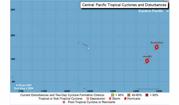
Tropical Storms Carlotta and Daniel are seen as of 5:35 p.m. today.
NATIONAL HURRICANE CENTER
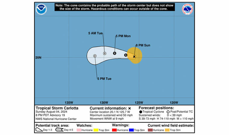
The full forecast of Tropical Storm Carlotta as of 5:35 p.m. today.
NATIONAL HURRICANE CENTER
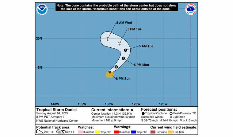
The full forecast of Tropical Storm Daniel as of 5:35 p.m. today.


UPDATE: 5:35 p.m.
Tropical Storm Carlotta has been gradually spinning down as Daniel moves a little faster toward the northeast away from the Hawaiian Islands.
Carlotta was located about 1,035 miles west of the southern tip of Baja California with maximum sustained winds of 50 mph moving west-northwest at 9 mph.
Carlotta is expected to continue in the general motion with a slight decrease in forward speed over the next day or so.
“Further weakening is forecast and Carlotta is expected to become a remnant low on Tuesday, and dissipate by the end of the week,” according to the forecast.
Tropical-storm-force winds extend outward up to 80 miles from the center.
Don't miss out on what's happening!
Stay in touch with breaking news, as it happens, conveniently in your email inbox. It's FREE!
Daniel was located about 1,440 miles west-southwest of the southern tip of Baja California with maximum sustained winds of 40 mph moving northeast at 9 mph.
The storm is expected to continue in the general motion through Monday and turn toward the north and northwest Monday night and Tuesday.
“Small intensity fluctuations are possible during the next couple of days. Daniel is forecast to become a post-tropical remnant low on Tuesday,” according to the forecast.
Tropical-storm-force winds extend outward up to 70 miles from the center.
2 p.m.
Tropical Storms Carlotta and Daniel continued moving just east of the Hawaiian Islands.
As of 2 p.m., a weakened Carlotta was located about 990 miles west of the southern tip of Baja California with maximum sustained winds of 60 mph with higher gusts while moving west at 10 mph. The storm was expected to continue in the general motion with a slight decrease in forward speed over the next few days.
Maximum sustained winds have decreased from 65 to 60 mph. Tropical-storm-force winds extend outward up to 70 miles from the center.
“Additional weakening is anticipated and Carlotta is forecast to become a remnant low in a day or two. The subsequent remnant low is expected to dissipate around mid-week,” according to the forecast.
Meanwhile, Daniel had little change in intensity as it was located about 1,465 miles west-southwest of the southern tip of Baja California. The storm was packing maximum sustained winds of 40 mph as it moved northeast at 8 mph.
Daniel is expected to turn toward the north and northwest Monday night and Tuesday.
“Small intensity fluctuations are possible during the next couple of days. Daniel is forecast to become a post-tropical remnant low on Tuesday,” according to the forecast.
Tropical-storm-force winds extend outward up to 70 miles from the center.
EARLIER COVERAGE
Hurricane Carlotta weakened into a tropical storm as a new storm formed in the Eastern Pacific, according to the National Hurricane Center in Miami.
According to an 8 a.m. update, Carlotta was located about 930 miles west of the southern tip of Baja California packing maximum sustained winds of 65 mph as it moves west at 12 mph. Carlotta is expected to continue in the general motion over the next day or two. Carlotta’s forward motion is predicted to gradually slow down as it turns into a remnant low over the next couple of days.
Tropical-storm-force winds extend outward up to 90 miles from the center.
Swells created by Carlotta along the coast of the southern Baja California peninsula are expected to diminish today.
Meanwhile, Tropical Storm Daniel in the Eastern Pacific is moving north-northeastward.
Daniel was located about 1,500 miles west-southwest of the southern tip of Baja California packing maximum sustained winds of 40 mph as it moved north-northeast at 5 mph.
“A faster northeastward motion is forecast later today and Monday, followed by a turn toward the north and northwest on Monday night and Tuesday,” according to the forecast.
Daniel is expected to become a post-tropical remnant low on Tuesday.
Tropical-storm-force winds extend outward up to 70 miles.
There are no other coastal watches or warnings in effect.

 Holy Week & Easter in Aiea || Free Events for All at OSHi! ️️

